| John Bidwell |
Trail Guide |
Historical Background |
Aug 10 |
11 |
12 |
13 |
14 |
15 |
16 |
17 |
18 |
19-20 |
21-22 |
23 |
| 24-25 | 26 | Aug 27 - Sep 4 | 5 | 6 | 7-8 | 9 | 10 | 11 | 12 | 13 | 14 | 15 | All Photos |
| 24-25 | 26 | Aug 27 - Sep 4 | 5 | 6 | 7-8 | 9 | 10 | 11 | 12 | 13 | 14 | 15 | All Photos |
August 11, 1841
Travel west on US 30. At 1.2 miles are two historical signs on the left that explain about Soda Springs and Colonel Patrick Edward Connor. Continue west to OREGON TRAIL STATE PARK (2.7 miles).
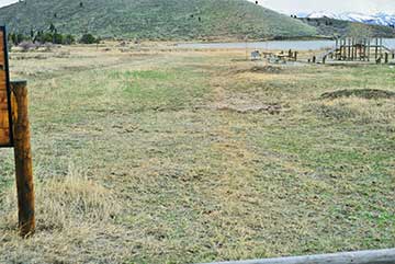
Optional tour to Oregon Trail State Park. Enter Oregon Trail State Park and note the trail ruts on the right and left of the road.
 |
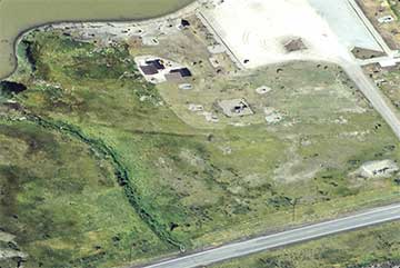 |
| Ruts from the Oregon Trail pass right through here (Look at the indentations from the lower left up towards the lake). The Oregon Trail State Park with a boat ramp and amenities for the reservoir was created in this area. | The Oregon/California Trail is ruts are in the center of this photo running from left to right. The reservoir is in the upper left of the photo and the Oregon Park parking lot is in the upper right. |
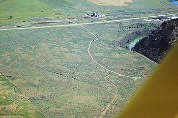 |
| This is the approximate area where the Bidwell-Bartleson separated from the rest of their party that left Western Missouri in 1841. The Oregon-California Trail was somewhere by the highway in the upper portion of the photograph. The trail turned northwest which is in the upper left hand corner of the photo and the Bear River is in the upper right side. The Bidwell Party were told to stay on the right hand or west side of the river. |
Optional tour to the Bear River overlook. Turn left onto the road by the Idaho highway maintenance station. Travel south 0.5 miles to a concrete dam on the Bear River. Note the channel depth of the Bear River as it flows west and then south. Return to US 30.
The Bear River heads in Utah's Summit County in the Uinta Mountains, flows through Wyoming's Unita County, Idaho's Bear Lake, Caribou and Franklin counties, and Utah's Cache and Box Elder counties along a meandering 350-mile course to empty into Great Salt Lake at Bear River Migratory Bird Refuge, 90 miles from its source. The Bear River is the largest river located entirely inside the Great Basin, its flow being exceeded only by the Green and Colorado rivers. At intervals along its course, dams impound and divert the waters for industrial and agricultural purposes.
Michael Bourdon, a twenty-one-year-old French Canadian fur trapper of the Hudson's Bay Company, is given credit for naming the Bear River in 1818 while trapping in the area. He was killed by Indians there the following year. The Indians had names for the river--"Quee-yah-pah" for Tobacco Root Water, and "Gull-yah-pah" for Tobacco Water. These names refer to the color of the river in its lower reaches. The name Michael Bourdon gave refers to the numerous black, brown, and grizzly bears found in the region at that time.
Continue west to the JUNCTION (1.0 miles) with a gravel road on the left.
BIDWELL / BARTLESON TRAIL - SEPARATION
First Overland Emigrant Party
"Having traveled about 6 miles this morning the Company came to a halt- the Oregon Company were now going to leave Bear river for Ft. Hall, ... here concluded to go into Oregon so that the California company now consisted of only 32 men and one woman and child, there being but one family. The two companies, after bidding each other a parting farewell, started and were soon out of sight."
John Bidwell, August 11, 1841
2002 Utah Westerners Foundation & Utah Crossroads Chapter OCTA BB ID - 1
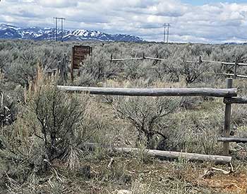 |
| This was said to be a emigrant cemetery but has not been proven. |
Continue west to the JUNCTION (0.9 miles) with SR 34. Optional tour to Oregon Trail ruts. Turn right onto old US 30. At 0.2 miles turn right, and continue east 0.5 miles to the mounds of dirt that block the road. On the left a fence ends. Park and walk past this fence about three hundred feet to view the Oregon Trail ruts in the sagebrush near the railroad fence. This is west of the location where the Bidwell-Bartleson party and the De Smet party separated, the Bidwell-Bartleson party going south and the De Smet party going northwest. John Bidwell described this separation:
"Having traveled about 6 miles this morning the Company came to a halt--the Oregon Company were now going to leave Bear river for Ft. Hall, which is situated on Lewis River, a branch of the Columbia many, who purposed in setting out, to go immediately through to the California, here, concluded to go into Oregon so that the California company now consisted of only 32 men and one woman and child, there being but one family. The two companies, after bidding each other a parting farewell, started and were soon out of sight, several of our company however went to Ft. Hall to procure provisions, and to hire if possible a pilot to conduct us to the gap in the California Mountains, or a least, to the head of Mary's river, we were therefore to move on slowly till their return. Encamped on Bear river, having come about 12 miles."
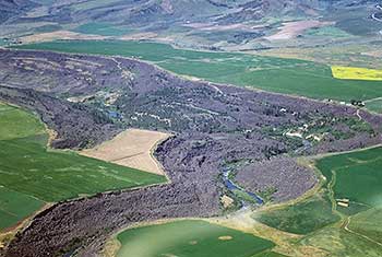 |
| This is an air photo of the Black Canyon of the Bear. So called because of the black volcanic rock that the river cut through during eons of time after all the volcanic activity 28,000 years ago. This canyon is west of Grace, Idaho. |
Travel west on Center Street. At 1.5 miles cross the Black Canyon of the Bear, where the Bear River has cut a deep channel through the black volcanic rock. This channel becomes deeper downstream as the Bear River cuts through the end of the volcanic rock and flows into the valley.
Continue west to the JUNCTION (3.0 miles) with the Hegstrom road. Turn left onto the Hegstrom road, continue to a bend in the road, then turn right and continue to the JUNCTION (2.0 miles) with Gentile Valley road.
Travel south on Gentile Valley road to the JUNCTION (1.9 miles) with Ralph Hanson road.
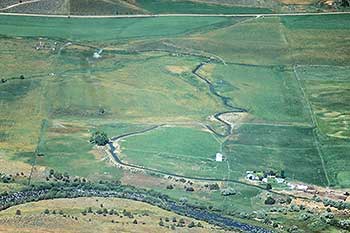
Optional tour to 11 August campsite. Travel east then south on Ralph Hanson Road, and at 0.9 miles stop on top of a hill, about four hundred feet from a house at the end of the lane. This is the 11 AUGUST CAMPSITE of the Bidwell-Bartleson party. Look west to the mountain and its two peaks and you will see where John Bidwell and James John saw snow on 11 August. John Bidwell described the scene:
 |
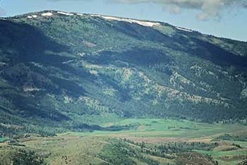 |
| This is the camp site of Aug. 11, 1841. The Bear River is at the bottom of the photo. The buildings on the lower right is the Ralph Hansen property at the end of the Ralph Hansen Road. The line at the top of the photo is Gentile street. | This is Sedgwick Peak that John Bidwell & James John climbed to obtain some snow on the hot Aug. 11, day. They climbed over the hills at the bottom of the photo, crossed the little valley and hurried up the mountain on the ridge that you can barely see running diagonally from left to right in the left center of the photo. They had to find shelter for the wet night under a stunted fir tree (unknown to them at the time) in a lair for grizzly bears. This air photo was taken on Aug. 11, 1993 showing snow still on the mountain. as John Bidwell & James John found it on Aug. 11, 1841. |
BIDWELL / BARTLESON TRAIL - MT. SNOW
First Overland Emigrant Party
"I, in company with another man (J. John), went some distance below the camp to fish in the river; fished sometime without success - concluded we could spend the afternoon more agreeably. ...We concluded to ascend the mountain, where were two spots of snow in full view, in order to enjoy the contrast between a scorching valley and a snowy mountain. Supposed the snow not more than 4 miles distant; set out without our guns knowing they would be a hindrance in ascending the mountain."
John Bidwell, August 11, 1841
2002 Utah Westerners Foundation & Utah Crossroads Chapter OCTA BB ID - 2
After midnight, Bidwell and John found a place to sleep under a stunted fir tree. In the morning, they discovered quantities of shaggy hair. This had been the lair of grizzly bears. They reached the snow that morning, and, after putting some in a handkerchief, they hurried down the mountain back to camp where they were chastised by Bartleson and greeted with joy by the rest of the party.
Return to Gentile Valley road.
| August 10, 1841 |
|---|