| John Bidwell |
Trail Guide |
Historical Background |
Aug 10 |
11 |
12 |
13 |
14 |
15 |
16 |
17 |
18 |
19-20 |
21-22 |
23 |
| 24-25 | 26 | Aug 27 - Sep 4 | 5 | 6 | 7-8 | 9 | 10 | 11 | 12 | 13 | 14 | 15 | All Photos |
| 24-25 | 26 | Aug 27 - Sep 4 | 5 | 6 | 7-8 | 9 | 10 | 11 | 12 | 13 | 14 | 15 | All Photos |
August 17, 1841
 |
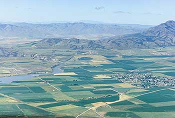 |
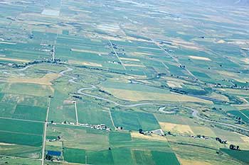
| This photo is looking west. The Bear River is in the lower center of the photo. The barrens is in the top portion with the Cutler Reservoir at the top center. | This photo is also looking west. The community of Newton is on the right hand- lower- center of the photo. Cutler Reservoir is on the lower right hand center of the photo. The Gates of The Bear is the where the Bear River Cuts through the Wasatch Mountains and can be seen in the left center of the photo. |
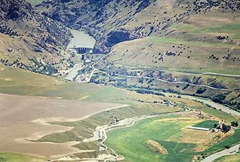
Continue south 1.3 miles to the junction with SR 218. Turn right onto SR 218 and travel 4.0 miles west, then 3.0 miles northwest to NEWTON (8.3 miles). Construction began in 1871 on the first storage reservoir in Utah, now called Newton Reservoir, located just north of the town. South of Newton is Cutler Reservoir, formed by Cutler Dam on the Bear River.
 |
 |
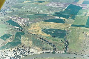
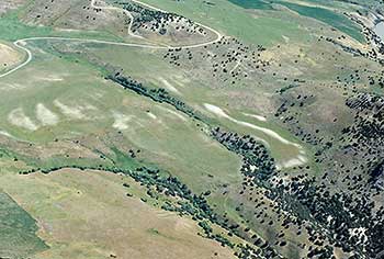
| This photo shows the gravel road at the top going over the mountain and is called the Long Divide. Cutler Reservoir is on the bottom of the photo. The trail would have proceeded from the right center to the left center of the photo. | This photo is looking east showing Cutler Reservoir in the right center and the Long Divide road going over the mountain. The Community of Newton is in the upper center. The trail would have passed between Newton and the river (where the reservoir is now) and to the lower right hand side of the photo in the lowest gap just above the single long white area. The waterfall mentioned by James John would be under the reservoir water just to the lower right center of the photo. |
Unable to see where the Bear River crossed the mountains to the west, the Bidwell-Bartleson party traveled along the north bank of the Bear River until they came to the narrows, and then crossed what is now called Long Divide.
 |
 |
| This is a closer view of the low pass by the Gates of the Bear in the upper right hand side of the photo. We assume that the trail would go through the lowest pass and then across the long white area. | This photo was taken in the lowest pass and looking west to the valley on the west side. This pass would be logical way for the wagons to travel. |
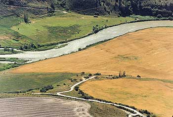
Travel through Newton to the junction with SR 142. Turn right onto SR 142 and travel northwest 1.3 miles to the junction with a gravel road on the left. Turn left onto this gravel road, and travel 1.0 miles to the junction with a northeast-southwest gravel road. Turn left onto this curving gravel road, and travel west 5.2 miles over Long Divide to the junction with 2800 West. Turn left onto 2800 West and travel south 1.8 miles until the ROAD BENDS (9.3 miles) westward. The 17 AUGUST CAMPSITE is about one mile to the southwest on the banks of the Bear River.
BIDWELL /BARTLESON TRAIL - GATES OF THE BEAR
First Overland Emigrant Party
"Today we travelled about 20 miles... Here the river runs through a deep cut in the mountain which is narrow and nearly perpendicular and about 300 feet high."
James John, August 17, 1841
2000 Utah Crossroads Chapter - OCTA BBU-2
James John described the river and the falls: "Today we travelled about 20 miles and encamped in Cash valley on the bank of Bear river 2 miles blow the falls of that river here the river runs through a deep cut in the Mountain which is narrow and nearly perpendicular and about 300 ft high."
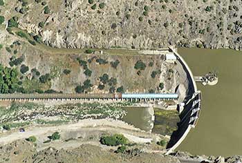
Cutler Dam, built just below the falls, impounds the Bear River and its Cache Valley tributaries. The Union Pacific Railroad cuts through these narrows on the south side of the dam.
 |
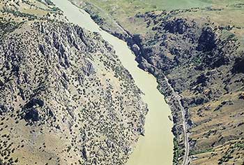 |
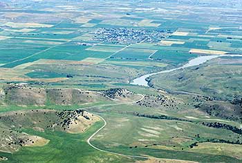
| This is Cutler Dam on the Bear River. The water is backed up, diverted in canals, and used for irrigation. | This is the deep cut through the Wasatch Mountains made by the Bear River over eons of time. The Union Pacific Railroad cuts through the narrows on the right side of the reservoir. The water fall mentioned by James John is under the reservoir by the ledge rock in the upper center of the photo. |
 |
 |
| This photo is facing east showing the Cutler Dam and the steep banks of the river below the dam. Because of these steep banks the emigrants would have to go further down stream. | This photo shows the only area where the emigrant wagons could have came down to the river avoiding the steep banks. This would have been the August 17th campsite. |
| August 16, 1841 |
|---|