| John Bidwell |
Trail Guide |
Historical Background |
Aug 10 |
11 |
12 |
13 |
14 |
15 |
16 |
17 |
18 |
19-20 |
21-22 |
23 |
| 24-25 | 26 | Aug 27 - Sep 4 | 5 | 6 | 7-8 | 9 | 10 | 11 | 12 | 13 | 14 | 15 | All Photos |
| 24-25 | 26 | Aug 27 - Sep 4 | 5 | 6 | 7-8 | 9 | 10 | 11 | 12 | 13 | 14 | 15 | All Photos |
August 18, 1841
Travel west through Fielding to the MALAD RIVER (2.5 miles). There is some irrigated land, large areas of dry farms, and grazing land on neighboring hills. When the country was first reconnoitered in 1877, it was covered with sage to the height of a mounted man's head.
 |
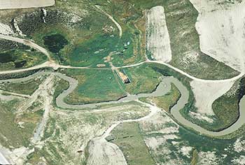 |
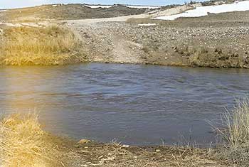
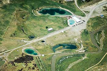
| This is Rocky Ford a prehistoric crossing of the Malad River used by Indians, Mountain Men, then emigrants. Because the Malad had steep banks, and a muddy bottom, it was difficult to cross. This was one of the best crossings because of the rocky bottom. | This air photo shows Rocky Ford of the Malad. The crossing is in the center of the photo coming in from the bottom center,crossing the river, then passing a hay stack in the center of the photo and continuing on to the upper center. Interstate 15 is just on the lower left corner. |
The Malad River drains south from Idaho into Utah and joins the Bear River just north of Corinne. Donald Mackenzie, a French Canadian trapper for the Hudson's Bay Company, is given credit for naming the river. He and his men became ill after eating beaver meat. "Malade" is French for "sick." Fremont called the river "Roseaux." Though narrow, this river was a big obstacle for early travelers because of its steep high banks and muddy bottom. The main crossing was Rocky Ford, southwest of the town of Plymouth. This ford had been used for centuries by the Indians, and was used later by the mountain men and overland emigrants.
Continue west to the JUNCTION (0.5 miles) with SR 13.
 |
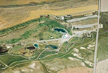 |
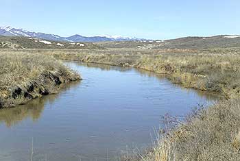
| This photo shows the slow, deep, muddy Malad River. Everyone had a problem crossing this`miserable stream. It got its French name meaning sickness, from the Mountain Men who got sick when they ate the Beaver meat. The Hudson Bay fur trapper Peter Skein Ogden doubted his men and ate some beaver meat and got violently sick for several days. The beaver apparently assimilated the poison from some plant roots. | This photo shows the Hot Springs mentioned by John Bidwell. The springs, in the center of the photo, are on the west bank of the river which is meandering below the springs and parking lot. John Bidwell wrote: "In ascending this stream in search of a place to cross it, we found on its margin a hot spring, very deep and clear." |
Optional tour to Rocky Ford (Private Property). A portion of this optional tour is on private property, and permission is required. Turn right onto SR 13, and travel north 3.0 miles to the junction with 19200 North on the left. A sign reading "Belmont Springs" is at this junction. Turn left onto this road, and travel west down a hill, crossing the Malad River. On the left is a hot springs resort called Belmont Springs or Uddy Springs. Continue west 1.0 miles from SR 13 to the junction with a gravel road (6000 West 19200 North). Turn right onto this gravel road and travel 0.5 miles to an unmarked gravel road on the left, in the Malad River bottoms. ? ? ? ?
This road is on private property, and permission is required to proceed. Travel west on this gravel road 0.3 miles, under an I-15 overpass structure, to some corrals. Park and walk about two hundred feet north to the Malad River crossing. This natural crossing is called ROCKY FORD, so named because of a layer of small rocks in the bottom of the river.
BIDWELL /BARTLESON TRAIL - MALAD RIVER
First Overland Emigrant Party
"Traveled but a short distance when we discovered that a deep salt creek prevented our continuing near the river. In ascending this stream insearch of a place to cross it, we found on its margin a hot spring, very deep and clear."
John Bidwell, August 18, 1841
2000 Utah Crossroads Chapter - OCTA BBU-3
 |
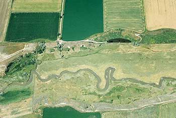 |
| This is a closer view of the Hot Springs which is now a resort. The Malad River runs through the lower right corner of the photo. Formally the Uddy Hot Springs, and then Belmont Hot Springs. | This photo shows the Malad River meandering through the lower half of the photo. Some where in this area is where the party camped on August 18th. Bidwell said that the river was so salty they could not drink it. James john said that they were only 5 miles from their last camp site. Even through they had traveled 15 miles that day. |
Return to SR 13 past the hot springs. John Bidwell described these hot springs:
"Traveled but a short distance, when we discovered that a deep salt creek prevented our continuing near the river. In ascending this stream in search of a place to cross it, we found on its margin a hot spring, very deep and clear. The day was very warm and we were unable to reach the river, encamped on this salt creek and suffered much for water, the water being so salt we could not drink it, distance 15 miles."
James John also described these hot springs:
"[T]his four noon we came to a muddy deep creek which we could not cross without going nearly a half days journey up it and consequently we travelled about 5 miles today and came down on the opposite bank and encamped there is a number of hot salt springs on the banks of this creek some of them are nearly as hot as boiling water."
Travel south on SR 13 through Riverside to the 18 AUGUST CAMPSITE (6.6 miles). The emigrants camped by the Malad River on the left. This site is five miles from the 17 August campsite. The Bidwell-Bartleson party traveled down the west bank of the Malad River, through today's Riverside, Garland, and Tremonton.
| August 17, 1841 |
|---|