| John Bidwell |
Trail Guide |
Historical Background |
Aug 10 |
11 |
12 |
13 |
14 |
15 |
16 |
17 |
18 |
19-20 |
21-22 |
23 |
| 24-25 | 26 | Aug 27 - Sep 4 | 5 | 6 | 7-8 | 9 | 10 | 11 | 12 | 13 | 14 | 15 | All Photos |
| 24-25 | 26 | Aug 27 - Sep 4 | 5 | 6 | 7-8 | 9 | 10 | 11 | 12 | 13 | 14 | 15 | All Photos |
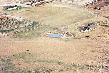 |
| This is an airal photo of Donner Springs which is in the center of the photo The spring and ranch is owned by Dean Stephens. The cabin on the right is used by Mr. Stephens and his family. The cabin up in the left hand corner is occupied by Mr. Stephens foreman and hired hands. Our OCTA Crossroads Chapter was allowed to place a log fence around the spring and 3 kiosks within the fence. |
September 14, 1841
Continue south to the TL BAR RANCH (4.5 miles), where Donner Spring is located by the trees. Some historians feel that the Bidwell-Bartleson Party stopped at Donner Springs but James John's diary does not indicate this. It reads:
"We started early this morning and passed a number of good springs, took dinner at one of them."
The distance traveled would place them at Halls spring. Continue southwest to the JUNCTION (4.7 miles) with the Hall Springs road. Turn left onto the Hall Springs Road and travel west to HALL SPRINGS (0.6 miles). The Bidwell-Bartleson party had dinner here on 14 September. The plaque reads:
BIDWELL TRAIL /HASTINGS CUTOFF - HALLS SPRING
"We started early this morning and passed a number of good springs, took dinner at one of them."
James John, Sep 14, 1841
2000 Utah Crossroads Chapter - OCTA HU-25
Return to the Lucin/Wendover road.
To the west is 10,700-foot Pilot Peak. Named by John C. Fremont, Pilot Peak is in Nevada, close to the Utah-Nevada border. The peak was a landmark to all emigrant parties moving west in this part of the country. Explorers, mountain men, trappers, and Indians also used the peak as their guide. It could be seen from great distances as emigrant parties crossed the Great Salt Lake Desert.
Continue southwest on the Lucin/Wendover road 5.9 miles to where the Bidwell-Bartleson party trail crosses the gravel road from east to west. This is where Edwin Bryant, traveling ten miles southwest of Donner Spring, saw an old wagon road on 5 August 1846. Bryant wrote: "After travelling about ten miles we struck a wagon-trail, which evidently had been made several years." He then recollected an expedition by Bartleson and Chiles that went to California.
Continue south and at 1.5 miles look westward where you will see a low pass, we named Bidwell Pass. West of Bidwell Pass 7.5 miles is the 14 SEPTEMBER CAMPSITE. John Bidwell wrote:
"Traveled about 25 miles and stopped about 9 o'clock at night, in the middle of a dry plain, destitute of water."
| September 13, 1841 |
|---|