SMITHSONIAN CONTRIBUTIONS TO KNOWLEDGE
ANCIENT MINING
ON THE
SHORES OF LAKE SUPERIOR
BY
CHARLES WHITTLESEY
WASHINGTON CITY:
PUBLISHED BY THE SMITHSONIAN INSTITUTION.
APRIL, 1863.
NEW YORK: D. APPLBTON & CO.
COMMISSION
TO WHICH THIS PAPER HAS BEEN REFERRED.
D. Wilson, LL. D.,
E. H. Davis, M. D.
Joseph Henry, Secretary S. I.
COLLINS, PRINTER,
PHILADELPHIA.
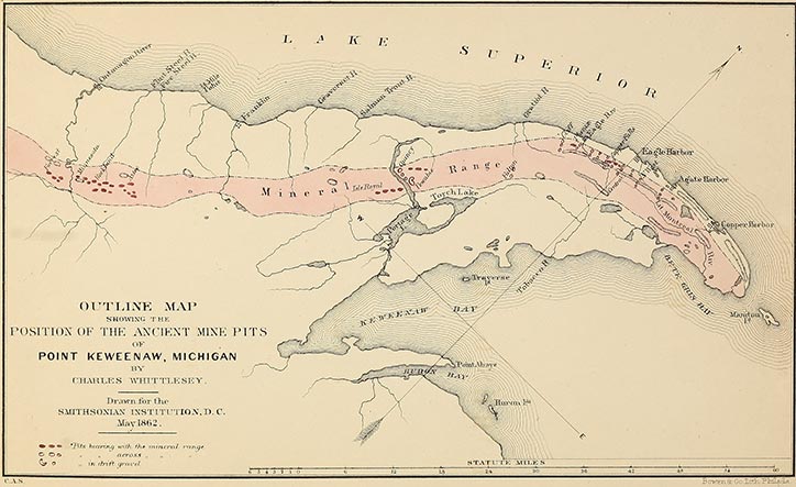
Outline Map showing the position of the ancient mine-pits of Point Keweenaw, Michigan, by
Charles Whittlesey.
ILLUSTRATIONS.
WOOD-CUTS.
ANCIENT MINING ON THE SHORES OF LAKE SUPERIOR.
PRELIMINARY REMARKS.
The evidences of ancient mining operations within the mineral region of Lake Superior were first brought to public notice in the winter of 1847-8. Although the Jesuit fathers frequently mention the existence of copper, and even use the term mines, it is clear, from the general tenor of their narratives, that they neither saw nor knew of any actual mining in the technical sense of that word. They announced as early as the year 1636 the presence of native copper, and refer to it as having been taken from the "mines." This was prior to the time when they had themselves visited the Great Lake, and their information was derived from Indians. At the same time they speak with equal certainty of mines of gold, rubies, and steel; but it must be borne in remembrance that the French word is not equivalent to our English mines, but may be more correctly rendered veins or deposits of metals or ores.In the "Relacions" for 1659-60, after missions had been established on Lake Superior, the region is reported to be "enriched in all its borders by mines of lead almost pure and of copper all refined in pieces as large as the fist, and great rocks which have whole veins of torquoise." It is probable that these accounts are second hand and such as the Chippeways gave when they exhibited to the fathers specimens of native metal in the shape of water-worn pieces and small boulders.
Boucher, in the "Histoire veritable," &c., in 1640, asserts that "there are in this region, mines of copper, tin, antimony, and lead." He speaks of a great island fifty leagues in circumference, which is doubtless the one now called Michipicoten, where "there is a very beautiful mine of copper." Copper was also found in other places in large masses "all refined;" in one instance an ingot of copper was discovered which weighed more than 800 pounds, and from which the Indians cut off pieces with their axes after having softened it by fire. All this information Boucher obtained from some French traders, and not from his own observation. Such is the tenor of the historical accounts from the time of Lagarde in 1636 to Charlevoix in 1721.
Detached and water-worn lumps of copper have been found in great numbers in the gravel, clay, and loose materials that cover the rocks, from the days of the Catholic fathers to this time, not only in the mineral region but over a large space to the southward of it. All these pieces were originally from veins, but have [pg 2] probably been separated by the same cause that gave rise to that formation which geologists call the "drift."
The agent, whatever it was, that broke off fragments from the rocks, not only on Lake Superior but further north, and transported them in the shape of boulders, sand, and gravel, as far south as the valley of the Ohio, also bore along the contents of the mineral veins which those rocks contained. Pieces of native copper are well calculated to resist the severe attrition to which transported materials are subjected. Masses of it have been found not far removed from the mineral range, weighing 3000 lbs., and others at a greater distance have been taken from the beds of rivers and from the beach of the lake weighing 1500 and 800 pounds. Others again of less size have been recovered from the gravel of the Menominee River, near the shores of Green Bay, and at Sheboygan Falls near the town of Sheboygan on Lake Michigan. Professor J. Brainard, of Cleveland, has a piece weighing five or six pounds which was found five feet beneath the surface in the drift gravel of Rocky River, Medina County, Ohio.
Had the Indians, the French, or the Jesuits of early times, discovered copper on the shores of Lake Michigan or of Lake Erie, not knowing or supposing the metal could exist except in mines, they would probably have spoken of it as having been found in a mine. The attention of the fathers was not particularly called to the subject of mineralogy, and although they were learned men, their knowledge of geology must have been very limited, for this science had not at that time assumed a place in the schools.
As to the accounts given by savages, every one who has had much intercourse with them, knows that great allowance must be made for their want of knowledge and their tendency to embellishment and exaggeration. I have listened to many wonderful tales concerning distant mineral riches. An aged Chippeway, by the name of Kundickan, whom I met on the Ontonagon in 1845, stated that as he was one day sailing along the western shore of the Gogebic (or Akogebe) Lake, at the head of the west branch of that river, he heard an explosion on the face of a rocky cliff" that overlooked the water, and saw pieces of something fall at a distance from him, both in the lake and on the beach. When he had found some of them, they proved to be a white metal, like "Shuneaw" (money), which the white man gives to the Indians at La Pointe. There are good reasons why the old missionaries should have had greater confidence in such stories than we have, and thus have given them a place in their reports to the Propaganda. But with all the influence possessed by them over the Indians, and the closeness of the ties that could not fail to exist between a priest and his converts, no instance is referred to where they were shown mining operations upon the rocks or veins.
There is nothing to show that the Indians wrought copper in mines at that time. They had no implements proper for the purpose; nor did they produce samples of metal taken from its position in sitû. The Indians had neither copper kettles nor axes when the French came among them; but only rudely fashioned copper knives, that were evidently beaten out from small boulders. Instead of viewing copper as an object of every day use, they regarded it as a sacred Manitou, and carefully preserved pieces of it wrapped up in skin in their lodges for many years; and this [pg 3] custom has been continued to modern times. I am well aware that they have a superstitious dread of showing a mineral mass or locality to a white man, believing that the Manitous will visit them with some calamity if they do so.
The missionaries, however, frequently overcame this feeling in regard to copper boulders, and could as easily have done so in regard to mines, if any such had really existed. If the Chippeways had been cognizant of the ancient works that have been recently discovered, they would have communicated this fact to their spiritual fathers, who would not have suffered so interesting a fact to be lost.
If the Indians possessed traditions from their ancestors relating to ancient mines, or the people who worked them, those must also have come to the ears of the Jesuits. With the exception of an old Chippeway chief who resided some years since at Fon du Lac (Lake Superior), I have known of no one pretending to such knowledge. The story he gives is sufficiently imaginative, and relates to mines wrought by his tribe on Isle Royale, in times long past, when his fathers were much happier, and had larger canoes than his contemporaries have now. I place his narrative in the same category with those above noticed, as having reference to boulder copper, and not to that obtained from mining in sitû.
From evidences which I shall give, in describing the works in detail, it will appear that they were abandoned several hundred years before the French became acquainted with the northern tribes; no mines having been found that could have been wrought as late as the time of the earliest Jesuit. If such were wrought by Indians, it must have been at a period very remote, such as Loons Foot describes. But could the natives have lost the recollection of such a state of things? Had they ever worked mines, they must have possessed the skill to fashion the metal extracted from them into various useful forms, without Which it would be of no value. Neither the skill nor the implements themselves would have been lost in a few hundred years, by a people having the same wants, and residing in the same country.
It also seems to be highly improbable that their ancestors either knew of ancient mines, not worked by themselves, or the people who wrought them. Tradition is the only history of savage nations, and the fault of this species of knowledge is not in the absence, but in the excess of materials such as they are.
Among thousands of legends which the Indians have related, nothing positive or consistent has come to my knowledge respecting the people who preceded the present Aborigines, except a tradition communicated to Major Long, in 1819, upon the Great Miami River, by an Indian chief, during his Expedition to the Sources of the Mississippi. Aside from this, I have heard of nothing coming from the Western tribes concerning the origin of the tumuli and earthworks that are so conspicuous in Ohio, Kentucky, and other Western States. As a people, if we may judge by their silence on a subject on which they may be supposed inclined to be communicative, if they had anything to tell, the aborigines have no traditionary knowledge of their predecessors, the race of the "mound builders." Neither do we find in the record of English travellers who succeeded the French in 1763 any notice of ancient mines. [pg 4]
Description of the Locality of the Remains of Ancient Mining Operations, &c.
In casting the eye over a map of Lake Superior, a remarkable projection, in the form of an immense horn, will be observed jutting out from the south shore, and curving to the northeast until it ends in an irregular point.
This peninsula, which is called Keweenaw Point, is about eighty miles in length, and at the place where it joins the main land forty-five miles in width. Through the whole extent of this projection a belt of metalliferous trap formation extends, differing at various points in structure, and in the character of its contents. Along this belt, which is designated on the map by dotted lines, there are exhibited, throughout nearly its whole extent, a disturbance of the strata, and upheavals comprising a series of bluffs, rising abruptly from the two streams. Eagle and Montreal Rivers.
Within this belt, all the mining operations, ancient and modern, have been chiefly confined. The most remarkable feature of the district is the character of its metalliferous products, which occur, not in the condition of an ore of copper, but exclusively as native metal. This is met with in immense masses, in veins of smaller size, and in rounded nodules. The cutting of the masses is a tedious and costly process, and in some instances, even with all the appliances of modern art, requires several months before a single mass is entirely removed from the mine. The metal is sometimes almost entirely free from foreign matter, yielding when melted down in the furnace from 90 to 95 per cent, of copper.
The first actual mining operations, within historic times, were commenced near the forks of the Ontonagon, in 1761, by Alexander Henry, but under the peculiar circumstances they proved entirely abortive. In 1841, Dr. Douglas Houghton made a report to the Legislature of Michigan, in which the earliest definite information in regard to the occurrence of native copper on Lake Superior was given to the public. Shortly after this, mining operations were commenced in this region, explorers and speculators flocked to it from all quarters, and in 1845 the shores of Keweenaw Point were whitened with their tents.
In 1846 the excitement reached its climax, after which a reaction took place, and finally only half a dozen companies out of all that had been formed continued the operation of mining in good earnest.
The first public announcement, so far as we are aware, of the remains of ancient mines in the copper region is that by Mr. S. O. Knapp, agent of the Minnesota Mining Company, in 1848. Dr. Chas. T. Jackson brought forward the subject in his Geological Report to the United States Government, in 1849, and gave some interesting details of what had been discovered up to that time. Further mention of it was made by Messrs. Foster and Whitney, in their report in 1850, and several illustrations were given. Since then our knowledge of the subject has been much enlarged by the prosecution of mining operations on the very sites of the ancient works.
It must not, however, be supposed that our information is now complete. It is by no means an easy task to discover remains buried, as those of the ancient mines of [pg 5] Lake Superior are, in extensive and dense forests, where the explorer can only see a few rods, or, perhaps, yards around him, and where there is seldom anything which rises sufficiently high above the surface to attract the eye.
They are, for the most part, merely irregular depressions in the soil, trenches, pits, and cavities; sometimes not exceeding one foot in depth, and a few feet in diameter. Thousands of persons had seen the depressions prior to 1848, who never suspected that they had any connection with the arts of man; the hollows, made by large trees overturned by the wind, being frequently as well marked as the ancient excavations. Besides this, there are natural depressions in the rocks on the outcrop of veins, formed by the decomposition of the minerals, that resemble the troughs of the ancient miners, as they appear after the lapse of centuries. There is not always a mound or ridge along the side of the pits, for most of the broken rock was thrown behind, nearly filling up the trenches. A mound of earth is as nearly imperishable as any structure we can form. Some of the tumuli of the west retain their form, and even the perfection of their edges at this day. But mere pits in the earth are rapidly filled up by natural processes. Some of those which have been reopened, and found to have been originally ten feet deep, are now scarcely visible. Others that have a rim of earth around the borders, or a slight mound at the side, and were at first very shallow, are more conspicuous at present than deep ones without a border.
There are, however, pits of such size as could not fail to surprise one at first view, were not the effect destroyed by the close timber and underwood with which they are surrounded. A basin-shaped cavity, 15 feet deep and 120 feet in diameter, would immediately attract the eye of the explorer were it properly exposed. But it is not unusual to find ten and twelve feet of decayed leaves and sticks, filling a trench, and no broken rock or gravel. In such cases a fine red clay has formed towards the bottom, a deposit from water, which indicates the long period of time since the excavation was made.
From the accompanying map it will be seen that the positions of the principal ancient mines correspond to those which are worked at present. There are three groups or centres of operation in both cases, one a little below the forks of the Ontonagon River, another at Portage Lake, and a third on the waters of Eagle River. Other works are known to exist, and more will probably be found; but we have probably discovered the most important ones within the district embraced by the map.
Although the old works are not always situated upon what would be considered good veins, yet they are regarded by practical miners as pretty sure guides to valuable lodes.
In the opening of our principal mines, we have followed in the path of our predecessors, but with much better means of penetrating the earth to great depths. The old miners performed the part of surface explorers.
In giving detailed descriptions of the antiquities of the mining country, we shall commence with those most easterly, near the extremity of Point Keweenaw, and proceed along the mineral range in the order of position to the southwest. There are, however, ancient works found over a much greater space than is included in the map.
[pg 6] The veins on Isle Royale, and near the north shore, opposite Point Keweenaw, were extensively wrought in olden times.
In the other direction, sixty and eighty miles to the southeast, in the iron region near Marquette are remains that are also ancient, and which will be noticed hereafter.
No doubt future examinations will bring others to notice on the continuation of the mineral range to the southwest, as it extends in that direction into Wisconsin.
DESCRIPTION OF THE SEVERAL WORKS.
1st Group.
The Agate Harbor Company has an extensive property on the range south of Agate Harbor, on which there are reported to be Indian diggings, as these excavations are frequently called by the miners. They are well developed at the works of the Native Copper Company, on the northern slope of the range, and on the Northwest Company's grounds at their mines, south of the "Greenstone" cliffs. The same veins extend across both these locations, a distance of a mile and a half, indicated by the presence of old works.
At the Northwest Mine the pits are conspicuous, showing on the surface the position of three veins that have since been wrought. Stone maids were abundant in them. Some of the pits had been made in a band of red conglomerate, which lies between the strata of greenstone (or crystalline) and amygdaloid trap. This conglomerate is composed of pebbles and boulders principally of red trap, cemented by argillaceous red sand, forming a very compact stratum, twelve to twenty feet thick. It here carries copper in small grains or pieces, near the veins; also crystallized calcareous spar and epidote.
The ancients did not neglect the most trifling indications of metal, but appear to have instituted a thorough investigation as to whether the copper existed in true veins, in metalliferous bands, or in detached nests. There is nothing remarkable in their operations at the "Native" Copper and the "Northwest" mines, except this closeness of pursuit, through all the veins and branches to their most minute extremities.
Waterbury Mine.—The works of this Company are situated about one mile and a half west of the Northwest Mine. A person passing to the interior from Eagle Harbor or anywhere along the northern shore of Point Keweenaw, and crossing the mineral range to the valley of the Little Montreal, witnesses everywhere the same topographical features. The mountain range rises from the lake level, in the distance of a mile, to an elevation of 500 and 600 feet; in the next mile the ascent is less precipitous, but the ground continues to rise from one to two hundred feet more. From the summit of the range there is along the whole line, from the extremity of the point to the Albion location, two miles west of the Cliff Mine, a vertical wall of naked trap rudely columnar, the upper edge, or crest, of which forms the summit of the range. This mineral front has the appearance of a vast upheaval from two to three hundred feet high facing the south, and about thirty [pg 7] miles in length. The ground from the bottom of this wall rises gradually to the south until it reaches another range of about the same elevation, thus forming a long narrow valley, through which flow, in opposite directions, the Montreal and Eagle Rivers. From the summit of the perpendicular cliff at the Waterbury Mine this valley presents a view extremely picturesque, and such as is seldom seen by the traveller in other regions. The general contour of the valley is curvilinear, so that the eye, placed at the middle of an arc in the position above mentioned, takes in the boundary ridge on each side as well as the whole inclosure. At the Waterbury Mine, which is situated near the middle of the length of the valley, there is in the face of the vertical bluff an ancient artificial recess or cavern, which is twenty-five feet in horizontal length, fifteen feet high, and twelve feet in depth. In front of it is a pile of the excavated rock, on which are now standing, in full size, the forest trees common to this region. Some of the blocks of stone which were removed from the recess would probably weigh two or three tons, and must have required the use of levers to dislodge them from their original position. Beneath the surface rubbish the remains of a gutter or trough composed of cedar bark were discovered, the object of which was clearly to conduct off the water Which was baled from the mines by wooden bowls, of which mention will be made hereafter. Portions of fine or pulverized copper scales remained in the upper end of this trough. After removing the water and decayed leaves at the bottom of the excavation a piece of white cedar timber was found, one end of which exhibited the marks of a cutting instrument like those of a narrow axe.
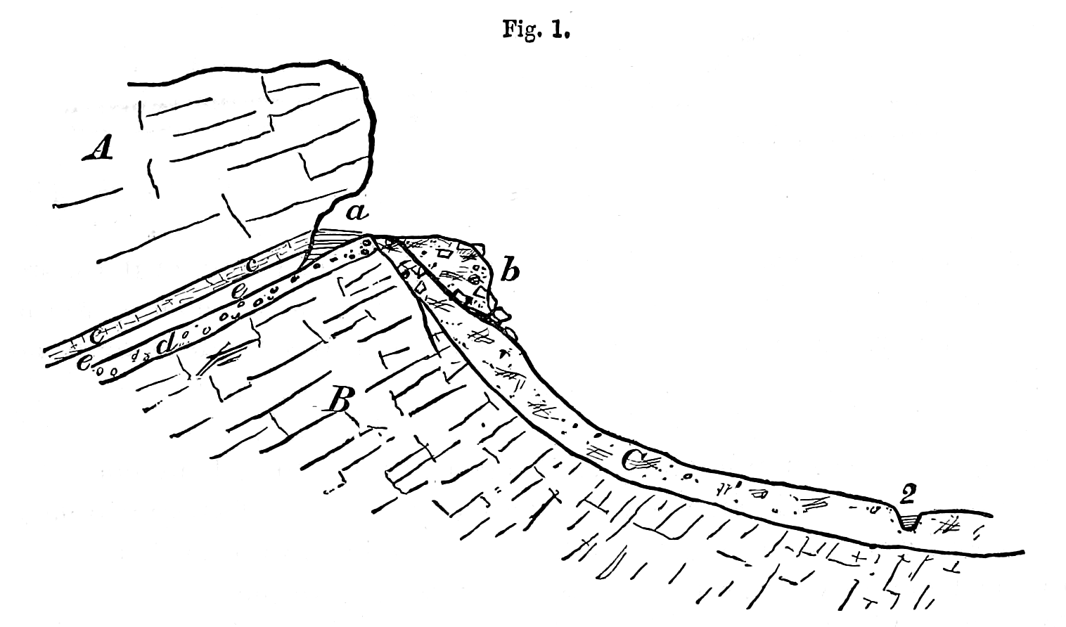
Fig. 1. WATERBURY MINE, artificial cavern.—A. Crystalline or greenstone trap, dipping N. 28°.—B. Amygdaloid trap.—
C. Talus of the bluff and drift.—a. Ancient rock excavation.—b. Rubbish thrown out of a.—d. Conglomerate
bed.—c c. Jointed chloritic bed.—e e. Inclined shaft of Waterbury Company.—2. Little Montreal River or
creek.
The above profile is made at right angles to the bluff, and shows the geological structure as seen from the western side. It would answer equally well for the North, West, North Western, Eagle River, Cliff, or any mine situated on the southern face of the coast range of Point Keweenaw.
[pg 8] The copper bearing amygdaloid (B) is separated from the crystalline or " Greenstone" trap (A) by a parting of conglomerate (d), which is however sometimes wanting, and its place supplied by a thin bed of red clay called "flucan" overlaid by a layer of quartz carrying specks of copper. This parting, whether it be of red conglomerate or of flucan and quartz, is known as the "slide," and sometimes (though improperly) is called a cross-course. The beds all dip northerly and at an angle of 28°. Resting immediately on the slide, and composing the inferior face of the greenstone stratum, is a bed of blackish-green chloritic rock (c c) very much jointed, which contains between its joints, in a leafy state and in its mass in a state more solid, scales, particles, and lumps of copper. This chloritic bed is from 12 to 15 feet thick, and in it the ancients worked forming this cavern. They did not operate on a vein at this place.
The Waterbury Company, encouraged by the labors of their predecessors, followed from the bottom of "a" along the surface of the conglomerate by an inclined shaft "E E" to a depth of 300 feet, measuring on the slide.
In removing a part of the old burrow B, Dr. Blake discovered several shovels, of white cedar, resembling the paddles in form now used by the Chippeway Indians in propelling their canoes. Had these been found elsewhere, they would have been regarded as ordinary paddles, but in this place they had evidently been used as shovels. This is also evident from the manner in which the blades are worn, as shown by the lines a a, b b, c c, in the annexed sketch.

Fig. 2. Wooden Shovel, 3 1/2 feet long—Waterbury Mine.—a a a. Original form.—b b. Partially worn.—c c. Worn obliquely.
The blades are more worn on the under side than the upper, as if the mineral had been scraped together and then shovelled out, as is the practice of the miners of the present day. The shovels which were found beneath the water level were sound in appearance, and the strokes of the tool by which they were formed remained perfectly distinct, but on being dried they shrunk very much, opening in long cracks, the wood retaining little of its original strength or hardness.
A birch tree, two feet in diameter, grew directly over one of these paddles.
A portion of a wooden scoop, or bowl, was found in the pit, evidently intended to dip up and to pass water. Its edge had been worn, like the shovels, by scraping over the rock; but it was so much decayed that it fell to pieces when it was taken out.
I examined the walls of this cavern minutely, hoping to find the marks of some tool of metal. The effects of blows of stone mauls were visible, and such is the hardness of the rock, that if drills or picks had been used upon it, I think the marks would be easily seen, particularly on that part which was protected from the atmosphere by water.
At one place something resembling the impression made by the point of a light sharp pick was discernible, but not very plain, and only in a single instance.
[pg 9] In the Porcupine Mountains I have seen works made by the English miners in the years 1769 and '70, where an adit or open cut made in the face of a cliff has been always exposed to the frost and rains. But here the marks of picks and drills appear as fresh and as perfect as if they had been recently made, although in some places the sides of the cut are covered by old lichens and mosses.
Copper Falls Location.—The ancient miners made very extensive excavations on the property of the Copper Falls Mining Company, both upon veins and metalliferous bands, which run parallel with the formations. By the profile and explanations here given the geological structure of the place will be well understood.

Fig. 3. Section on the Copper Falls Vein. Explanations.— Trap rock.
  Conglomerate beds.
 Sandstone.—a a a. Ancient pits on the vein.—b b b. Shafts and galleries of the mine.—c. Sand dunes.—d d.
Copper bearing bed of trap.
Sandstone.—a a a. Ancient pits on the vein.—b b b. Shafts and galleries of the mine.—c. Sand dunes.—d d.
Copper bearing bed of trap.
Trap rock. Conglomerate beds.
Sandstone.—a a a. Ancient pits on the vein.—b b b. Shafts and galleries of the mine.—c. Sand dunes.—d d.
Copper bearing bed of trap.
Scale—horizontal and vertical—2 inches to the mile. 1, 6, 7, Nos. of the shafts.
This sketch illustrates the geology of the northern part of the range, or of all mines described under the head of Copper Falls Location.
From this it will also appear that when we use the term extensive, as applied to "Indian diggings," it is only in a comparative sense, and in reference to other works of the old miners. The levels and shafts constructed by the Copper Falls Mining Company, since 1851, cause the mining of the ancients to appear like mere exploratory pits.
On looking at the map, the pits will be seen to occupy a total length of several miles on this location; but none have been reopened that had a greater depth than twenty-four feet, while the modern shaft has already descended more than 250 feet, and the mine has rock galleries of greater total length than all the old trenches of the ancients. In the profile their pits are shaded, and represented at a a a, occupying about half a mile on the "East Vein," or as it is sometimes called, the "Copper Falls Vein." Before they were obliterated, as they are in part now, the surface appearance was that of an irregular channel or trough ascending the mountain from the edge of the sandstone beds to the band d d, which carries copper. Here a system of basin-shaped cavities, broad, circular, and deep, crossed those made on the vein. They are denoted by heavy black dots on the map.
The first named series were from two to five feet deep and five to ten broad, and the latter five to eighteen deep, with a diameter of twenty to 120 feet. Forest trees and underbrush stood alike within and without them.
[pg 10] There is a heavy vein half a mile west of the East Vein, which is styled the West or the "Hill Vein," where the old works are similar in all respects to those above noticed and sketched on the East Vein. Those on the "Owl Creek" Vein are not so extensive, because the creek occupies the "back" of the lode. Still further east other veins are seen with pits, not only on this location, but on that of the Eagle Harbor Mining Company. Broken stone mauls are common in all of them. About the point where the Owl Creek crosses the "scoriaceous" or metal bearing bed d d, the excavations on that bed near the creek are very marked. Here is something similar to the cave on the Waterbury Location.
A very large pit to the east of Owl Creek was partially explored by S. W. Hill, Esq., the Superintendent of the mine, in 1852. By running in an adit on a level eighteen feet below the edge of the depression, after passing some distance in the gravel, rock was met in place; cutting through this at a distance of 100 feet, the miners discovered loose fragments and rubbish that had been handled, and pieces of timber still in good preservation. The adit was not deep enough to drain the pit to its bottom, and its depth was not ascertained. I have in my possession a portion of a pine tree from the end of this adit, in complete preservation, except a part which was charred by fire. The adjacent rock contained sheet copper, and small lumps, being a part of the metalliferous band.
By examining the section, it will be seen that the order of succession in the strata is as follows:—
Beginning at the shore of the lake first, a bed of trap, that dips northerly. It rests upon a stratum of red conglomerate of great thickness, dipping conformably under the trap, and is succeeded by conformable and alternating beds of trap and red sandstone, known by the geologist as the "Potsdam" red.
In these beds the mineral veins are not rich enough for working; a fact which the ancients knew full well, for it was only on the regular and uniform strata of trap underlying the variable beds that they expended their labor.
On clearing out some of the old pits, Mr. Hill found wooden shovels like those at the Waterbury Mine, more or less worn and of the same size and shape. In the bottom of trenches, and among the rubbish, the workmen saw continually ashes and charcoal, with other traces of the presence of fire. They threw out frequently broken hammers or "mauls," with a groove around the middle. These mauls weigh from five to fifteen pounds, and are merely oblong water-worn boulders of hard, tough rocks. Nature has done everything in fashioning them, except the groove, which was chiselled around the middle. They were collected from the smooth boulders of the lake shore, and from banks of coarse gravel that abound in the country. Most of them are trap; but the hornblende, sienitic and granitic rocks furnish some. The ring or groove appears to have been cut for the purpose of attaching a withe, to be used as a handle, wherewith to swing the maul. In one of the trenches on the Cliff Mine, north of the upper engine, one was found with a root of cedar still twisted in the groove, but so much decayed that it fell to pieces and was not brought away. Dr. M. D. Senter, of the Cliff Mine, states that he saw it before being disturbed, and it was evidently the intention of the operators to use the twisted root or withe for a handle.
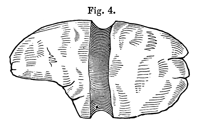 |
| Fig. 4. Stone Hammer or Maul, with one groove, and broken by use; length 7 inches. Copper Falls Mine. |
Most of these hammers are fractured at both Ends, and the peculiar sharp cut character of the fracture in many cases indicates that the implement had been used to drive metallic wedges, such as quarrymen call a "gad." Copper gads of this kind have been found in old pits at the Minnesota Mine. It will. be seen also that there are heavier mauls with double grooves, probably to be handled by two men.
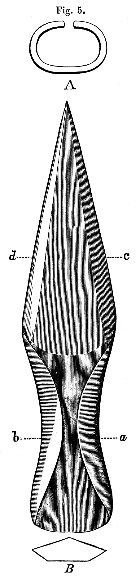 |
| Fig. 5. Copper Spear-head—Copper Falls Mine.—B. Section of blade at c d. A. Section of shank at a b. Scale, full size. |
In the description of works at the Central Mine, a class of hammers will be noticed without a groove. The one here figured was taken from a pit near Shaft No. 1 of the section above given. Not far to the south of the same shaft was found a copper spear or javelin head, in the rubbish near the bottom. Three others were found by Mr. Hill on the surface. One of them was so much corroded that the socket was nearly gone. The other I have sketched of natural size and thickness, from the original in the possession of Mr. Hill. It was evidently formed by beating the metal while cold, probably between stones, having a rough and not a polished exterior; it is not much decayed. The section of the blade B shows that its two faces were not symmetrical. A piece of decayed wood was found in the socket of one of them, being apparently the remnant of the shaft, by which it was hurled. As the edges of the "shank" or socket are not soldered together, but only bent around the shaft, it was probably wound with some ligament to give it strength. It is too large and heavy for an arrow-head; neither has it the shape proper for that purpose.
The description here given of the pits of the east vein will answer for almost all others.
In working the surface of the vein, or of the copper-bearing bed, the ancient operators must have wrought open to the day. They no doubt commenced as low down the slope of the range as the copper appeared to them worth being taken out, and worked upwards towards the south, in order to keep their drainage. From their rude and tedious method it was of the highest consequence to cause the water to flow away behind them, without the necessity of baling.
The "attle," or broken rock, was generally thrown back into the vacant space whence it had been taken: but little of it was cast out to right and left along the margin of the vein, which explains why the pits are so shallow at the present time.
In many places on this location, the vein is wide enough to allow men to work between its walls.
[pg 12] Thin sheets of copper were left standing at the bottom of the ancient excavation, which might readily have been extracted, and it seems singular that they were not.
Central Mine.—Near the road from the "North Western" to the "Winthrop" Mine, in an open grove of sugar trees, a depression was observed about five feet deep and thirty feet in length. It was generally free from water, and differed so little from cavities that are not artificial, but which are due to geological causes, that it did not attract much attention.
Mr, John Slawson, the agent of the North Western Mine, after a careful surface examination, concluded that this pit was not wholly due to nature, and the tract was on that account purchased for mining, in the fall of 1854.
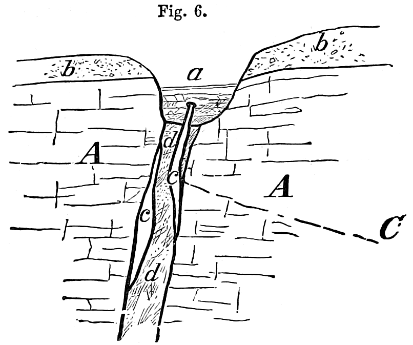
Fig. 6. Central Mine. Section of the vein and old pit. East and west.—A A. Trap rock wall of the vein d d.—a. Ancient
excavation partly filled.—c c. Masses of native copper in the vein.—b b. Drift gravel covering the rocks.
The Central Mining Company having been organized, a drain was constructed to take off the water, which was no sooner done than all doubts were removed; about five feet in depth of leaves and rotten sticks had accumulated at the bottom, among which a hard substance could be felt with a stick.
This proved to be a flat piece of native copper C, from five to nine inches thick, and nine feet in length, forming part of a large vein d d, as shown in the profile. The vein material had been worked away from one foot to eighteen inches along side of it, and it extended forward as well as downward in the vein. Its upper edge had been beaten by the stone mauls so severely, that a lip, or projecting rim, had been formed, which was bent downwards, over the sides. A large number of broken mauls were found in the place, and around it on the surface, all of them without grooves, of which the annexed woodcut is an illustration.
I have seen similar ones on the Humboldt Location, next west of Copper Falls. Where this class of stone hammers is found, those with grooves are wanting. The grooveless ones appear to have been used for percussion only at one end, as though the manner of holding them was such that a blow was not given on the other. The Peruvians have a copper axe without an eye, or a groove, to which, however, they attach a handle in the form of a split stick, bound with thongs. The ancient miners, probably, had some such mode of tying a handle to these smooth [pg 13] oblong stones. Different parties of men may have preferred tools of different kinds, Which would account for mauls, which are seen at one mine, being among themselves alike, but dissimilar to those at other places.
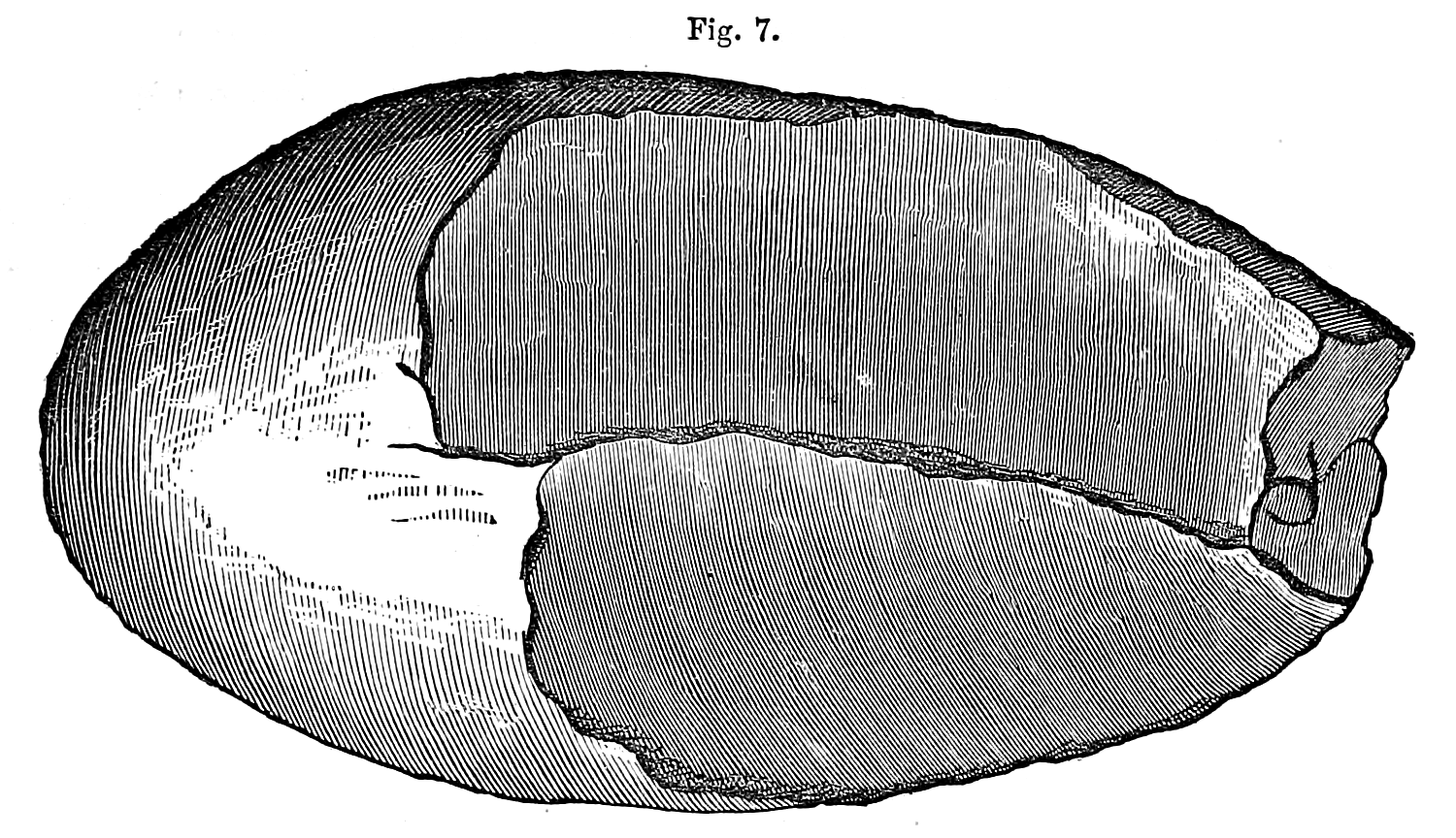
Fig. 7. Broken Maui, Central Mine.—Without groove, 1/2 size, weight 8 1/2 lbs.
The usual remains were here thrown out, consisting of charcoal, ashes, and broken wall rock.
The general bearing of the vein is 10° or 12° west of north. The section is made across it, east and west, looking south, and is vertical.
As the labor of uncovering the mass of copper progressed, another one was met with, overlapping the first, and adhering to the east wall. Further on, in the adit, a third mass was found, attached to the western wall, partly overlapping the one which the ancients had left.
By stoping out a space about sixty feet in length by twenty deep, on the vein, the Company took out fifty-three tons of mass copper. Such unwieldy pieces appear to have been beyond the control of the old miners. Their object seems to have been to secure small lumps, such as could be fashioned without melting. Whatever pieces might have been detached, by diligent pounding with their stone mauls, were broken off, and the remainder was abandoned.
It was impossible for them to cut into pieces, reduce by melting, raise from the pit, or transport blocks of metal weighing many tons. There are neither marks of a cutting tool upon them, nor of the action of fire. It is quite singular that they had not discovered the art of melting copper, which can be effected so easily in an open fire made of wood, but no evidences have fallen under our notice that this was done by that ancient race.
2d Group.
Portage Lake Region.
Quincy and Pewabic Mines.—Portage Lake resembles in form the long, narrow, and crooked Scottish lochs. Like them its quiet surface reflects the outlines of most exquisite scenery.It connects with Lake Superior through the channel of Sturgeon River, which has so little descent below the point of junction, that all material changes in the level of the great lake are felt throughout this inland water.
The Quincy landing is situated on the north side of Portage Lake, about twenty miles from Keweenaw Bay. The northern shore, which is nearly east and west at the landing, does not show rocks at the water level.
A succession of drift, knolls, points, and headlands, rising about 200 feet above the surface, overlook this shore. Above this elevation, and attaining a height of 500 to 600 feet, are seen projecting ledges and bluffs of trap rock, inclosing mineral veins. This rock is also visible at the heads of ravines where rivulets fall over low precipices forming small cataracts.
The first signs of ancient excavations occur near the lake level, and what is remarkable, are not in the rock, but in the sand and boulder "drift."

Fig. 8. Ancient Pits in the Boulder Drift or Gravel, Quincy Location.
The most capacious of these gravel pits, however, occur on a line nearly level and about 100 feet above the surface of the water.
[pg 15] They are partly upon the land of the Quincy Mining Company and in part on the Pewabic, a short distance east of the landing, as shown in the sketch. Those constituting the upper series are even, broad, deep, and regular, having the appearance of old fortifications. They extend around the headlands of gravel, connecting adjacent ravines, as though the object was to bring water from the rivulets along the face of the bluff.
At the points of the ridges they are much broader and deeper than they are at the heads of the ravines. The resemblance to a race way, or "sluice" for runnuig water, is such that it required much examination to convince me that they had not been used for that purpose. There are, however, no openings at the extremities, such as would have been the case in sluices, to admit and discharge water. A bench, or narrow terrace, breaking into the slope of the hill, forms a regular plateau for the uppermost group; the other groups being scattered along the slope at irregular intervals. Some of them extend down the declivity nearly to the water's edge. Pits of a peculiar shape are occasionally seen to the westward of the landing, particularly at the distance of about a mile. Here is a group of small ones covering several acres on a piece of level land, which is elevated about 200 feet above the lake, constituting one of the upper drift terraces.
There are no doubt many others, large and small, concealed by the thick brush wood with which the ground is covered. Mr. C. C. Douglass, formerly an assistant of Dr. Houghton, in the geological survey of the Upper Peninsula, and since for many years the superintendent of the Quincy and Isle Royale Mining Companies, states that lumps of water-rolled copper and small masses are frequently found on both sides of the lake in this drift gravel. In digging cellars, constructing roads, and exploring trenches, such pieces are so common, that it has been thought that they would pay for their collection by washing the earth. One mass of 1500 pounds weight was found in digging a cellar where there is no rock visible in place.
To obtain this transported mineral, Mr. Douglass conjectures to have been the object which the ancients pursued in their gravel trenches, and at the same time, that they selected from the water-worn boulders of the coarse drift such stones as had the proper size and shape for mauls, to be used in the adjacent rock excavations.
The earth from the trenches near the landing, on the slopes, was principally thrown out over the lower side, forming embankments with an extreme height of fifteen feet above the bottom of the ditch as it remains now after the lapse of centuries.
Some of the ditches are fifty feet wide at the present time.
The beds of trap, constituting the mineral range, at this place, have a total thickness of about a mile and a half, presenting the ends of the strata towards the lake. To reach the rock excavation of the ancients, it is necessary to follow a road from the landing up the mountain three-quarters of a mile to the north- east. Here the copper bearing rocks protrude from the soil in ledges; the intervals where no rock is seen being covered to a slight depth with earth. The veins of this part of the range have a direction different from those before described on Point Keweenaw. They have run with the formation, and not at [pg 16] right angles to it, like those at the Cliff, Copper Falls, Northwest, and other neighboring mines. The true lodes of the Quincy, Pewabic, Isle Royale, Portage, Huron, and other companies adjacent to Portage Lake, are called "parallels," while those further east belong to the system of "transverse" veins.
In the winter of 1854-5, after the land had been explored and worked ten years, a line of depressions was discovered on the summit of the range that attracted immediate attention. On this elevated ground the old operators had discovered and worked a rich deposit of copper which was nowhere visible upon the surface. The direction of the line of pits is northeast and southwest, corresponding with the range.
The mines now in operation on this lode are among the richest of Lake Superior.
At first view the excavations appeared to be irregular, like those in the gravel at the foot of the bluffs, but after clearing away the growing timber, they assumed an allignment such as I have given on the map. There are also veins in the vicinity that have a bearing different from the general course of the pits.
When the cavities came to be opened, it was evident that a deposit of great richness had been worked there in past times. Lumps of copper were found plentifully in the bottom of the old works, and with them the usual evidences of ancient mining. The pits are broad and deep, extending not far from half a mile.
Isle Royale Location.—This is on the south side of Portage Lake. Here the ground does not rise so high as on the north side, but is equally abrupt. The first escarpment on this side is rocky, its crest being reached by an ascent of 300 feet. The mining companies which have penetrated the rocky strata to a depth of at least 250 feet, are the Isle Royale, Portage, Huron, and Albion; all of them on the same vein, and situated near the south-easterly edge of the mineral range. The beds in which these companies have worked are, therefore, geologically, nearly a mile lower than those of the Quincy and Pewabic, which are near the westerly or north-westerly side of the range. It was, therefore, in different ground that the ancients sought for copper on the southerly side of the lake.
After having attained the summit of the lake front on this shore, we find the land nearly level for the distance of a mile, and the rocks covered with a shallow depth of earth. On this plateau the ancients discovered a rich lode that did not show itself on the surface.
In the autumn of 1851, Mr. Douglass informed me that there were indistinct signs of old works, half a mile from the lake on the northwest quarter of Section 1, T. 53, R. 34, owned by the Isle Royale Mining Company. At the request of the directors of the company, a close reconnaissance of the ground was immediately made by myself. It required some assistance of the imagination to conceive that the slight and irregular depressions, which were dimly visible among the trees, were the works of men. Applying a compass to such of them as could be seen at one view, and carrying this line forward, it passed over or near the successive pits for a distance of one-third of a mile. We then set men to work to cut down a cross trench through one of them, and in a few hours reached the bottom. The vein and its walls were distinctly visible, having been worked out to a depth of ten feet, [pg 17] but the space was filled with rubbish nearly to the surface. Further examination, and cross trenching, disclosed the vein along a distance of three quarters of a mile, in places very broad, with a bearing coincident to that of the formation.
It has now been worked to a depth of 250 feet, producing copper in rich masses, over a space twenty feet in thickness. In these wide places or pockets the early miners enlarged their pits to correspond, and carried their works to greater depths. Charcoal, broken mauls, and ashes are mixed with the black earth and rocky fragments of the pits.
3d Group.
Minnesota Mine.—As I have before stated, it was upon this location that the existence of mines, long since wrought, on Lake Superior was first made known to us. It is here, also, that the most extensive and interesting works of that kind are to be found.
The Minnesota lodes have a direction like those at Portage Lake, and different from those at Point Keweenaw. The veins about the forks of the Ontonagon, embracing a district of forty-five miles in length, on the mineral range, from the Douglass Houghton Mine, on the east, to the Akogebe Lake, on the west, run with the range, and not across it. Their bearing is, therefore, north-easterly and south-westerly, or about N. 54° East.
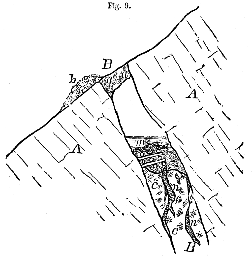
Fig. 9.
Minnesota Mine. Section across the Vein, looking from the easterly quarter. N. 30° W.—B B. Mineral vein
dipping north.—A A. Wall rock of compact trap.—a. a. Left standing a part of the original surface support
to the hanging wall.—m. Mass of copper sustained by timbers.—b. Ancient burrow or spoil bank.—c cn. Vein
matter embracing masses of copper n n.
On the Minnesota there is a group of veins nearly parallel among themselves, four in number, and on all these the ancients labored. The surface presents a corresponding [pg 18] group of rude trenches, showing the position of the veins, for more than two miles. The ground rises gradually to a height of 637 feet above the lake, but on the south drops suddenly off into a deep valley. The Ontonagon River cuts the range two and a half miles west of the mine, being navigable for batteaux to the landing.
In the above section, across the main lode, I have grouped together several remarkable objects, that were seen near each other, though not strictly in contact. The descriptions and sketches are in part due to Mr. Knapp, partly to Messrs, Foster and Whitney, and also to my personal examinations.
The vein B B has a variable thickness from one to nine feet, dipping northerly, at an angle of about 60° with the horizon. This is somewhat steeper than the dip of the strata, or wall rock, A A. On some of the veins, the excavations extend eastward, out of the Minnesota, into the grounds of the Rockland Mining Company, where they are very distinct. Being upon the southerly slope of the mountain, the ditches have become very much filled up by washing from the surface. The greatest depth of the ancient excavation is thirty feet. At the place of the above section the vein had been removed to a depth of twenty-six feet.
Not far below the apparent bottom of a trough-like cavity where shaft No. one is now situated, among a mass of leaves, sticks, and water, Mr. Knapp discovered a detached mass of copper weighing nearly six tons. It lay upon a cob work of round logs or skids six to eight inches in diameter, the ends of which showed plainly the strokes of a small axe or cutting tool about 2 1/2 inches wide. These marks were perfectly distinct. A piece of this wood which I took from the mine in 1849 proved to be a species of oak, the only species known upon the range, and by some called the Spanish oak. It shrunk on drying to about two-thirds of its size, cracking open in deep gashes, and possessed little strength. Its appearance was that of water-soaked timber not rotted, preserving its original form.
The mass of copper had been raised several feet along the foot wall of the lode, on the timbers, by means of wedges. Its upper surface and edges were beaten and pounded smooth, all the irregularities taken off, and around the outside a rim or lip was formed, bending downwards. This work had apparently been done after the miners had concluded to abandon the mass. Such copper as could be separated by their tools was thus broken off. The beaten surface was smooth and polished, not rough. Near it were found, as the excavation advanced, other masses, n n, imbedded in the vein. After several years, this vein has been found by the modem miners uncommonly rich and valuable for the size and number of its masses of copper.
Not far to the west of this spot a portion of the vein a a had been left like a pillar as a support to the hanging wall, while they excavated beneath. It is cut or bruised quite smooth, but shows no marks of other tools than the mauls. This rocky support is about four feet in thickness, and is high enough above the present bottom of the trench to allow a person to pass under it. The marks of fire on the rocks of the walls are still evident. Charcoal, ashes, and stone mauls are found in all of the pits hitherto cleaned out. One of the heaviest mauls yet seen, weighing thirty-six pounds, came from this location. It has a double groove, as shown in the annexed figure, which is not usual, and it was intended, no doubt, to be used by two men.
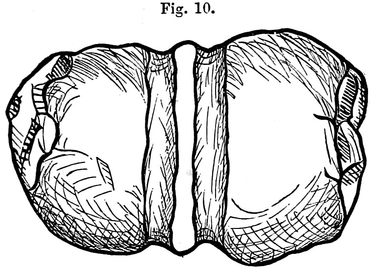 |
| Fig. 10. Stone Maul, with double grooves.—Weight 36 lbs. Minnesota Mine. |
In one of the pits a rude ladder was found, formed of an oak tree trimmed so as to leave the stumps of the branches projecting, on which men could readily descend or ascend to or from their work. Wooden levers are also found among the rubbish, preserved by water, which covered them continually.
On the edge of the excavation in which the mass m was found there stood an aged hemlock, the roots of which extended across the ditch. I counted the rings of annual growth on its stump, and found them to be two hundred and ninety. Mr. Knapp mentions another tree which had three hundred and ninety-five. The fallen and decayed trunks of trees of a previous generation were seen lying across the pits.
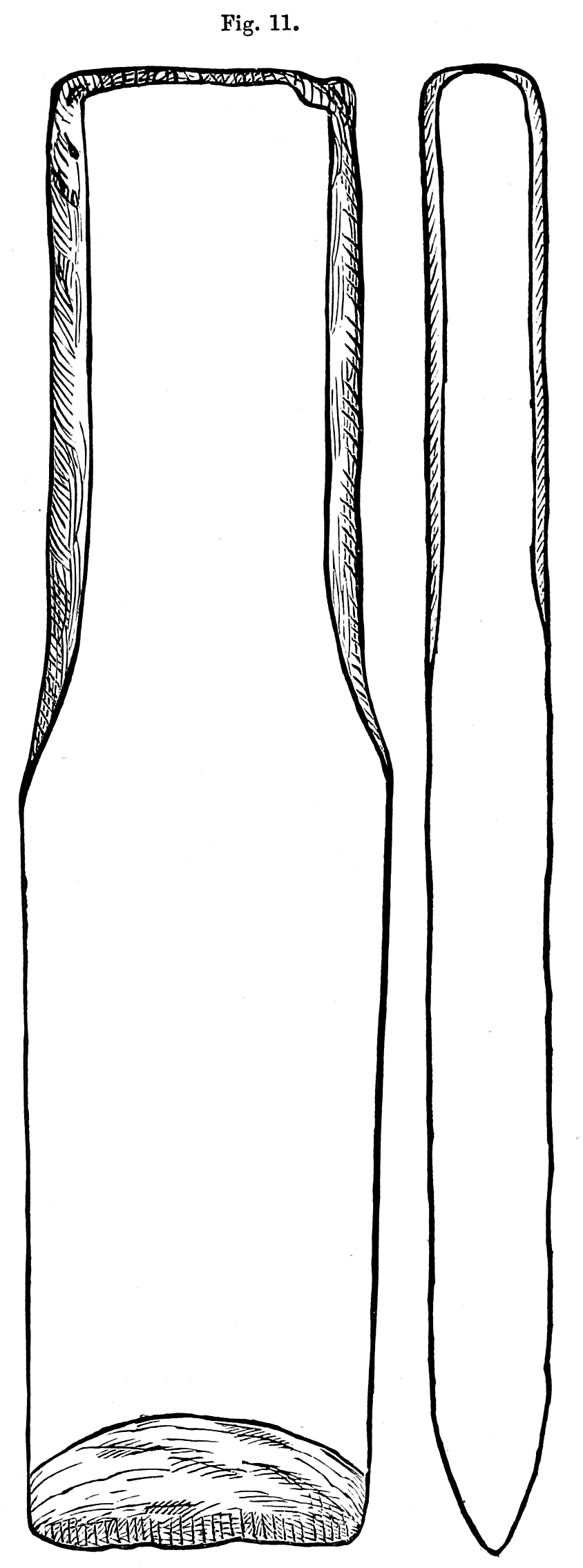 |
| Fig. 11. Copper Chisel. Full size.—Length 7 ¼ in.; breadth 1 3/4 in.; thickness 5/8 in. Minnesota Mine. — View edgewise. |
Near the place where the detached mass m was found Mr. Hill discovered a tool of which the following is a sketch, and near it a copper maul or sledge weighing from twenty to twenty-five pounds. Like all the other implements found this maul had been fashioned by pounding in a cold state. Originally the mass appeared to have had the shape of the letter T, the cross head at the top being about an inch thick and two or three inches broad, tapering towards each end. These two prongs had been folded over each other and beaten into a shape rudely resembling a man's fist, but larger. This lump of copper had evidently been battered either by pounding, to make it more compact, or by use as a maul. The handle of the maul was eight or nine inches long.
[pg 20] The chisel above figured was somewhat bruised at the upper end, as though it had been used. Towards the upper end the corners are taken off, apparently for the purpose of being held in one hand, while it was struck by a mallet with the other. It has a rough surface, common to these relics, but is symmetrical in form, with a bevel at the cutting edge on both sides. None of the tools show signs of having been ground to an edge on stone, but are beaten down roughly by hammers.
Artificial Caverns.—On the Aztec, Ohio, Adventure, and Ridge locations, in addition to the pits which are so common along the range, there are cavities in the mural faces of trap at various elevations, which are ancient and belong to the old copper works.
The bluffs are sometimes as high as three hundred feet above the valley. There are also breaks or gaps in the range formed by dislocations of the strata or faults, enlarged by the wearing action of the drift forces. The ends of different beds of trap are thus presented to view, rising on either side of the gorges, with precipitous fronts of different heights. One of the strata, and perhaps more than one, is metalliferous, like the scoriaceous bed worked at Copper Falls and at Phoenix Mines, on Point Keweenaw. At the Adventure the metal bearing stratum is very thick and highly charged with copper, disseminated irregularly through it. The ancients wrought upon it extensively, seeking with assiduity for the rich portions, no matter how difficult of access. Some of their excavations on the side of the bluff are scarcely large enough to shelter a bear. Others are more extensive, formed in all conceivable shapes, extending wherever indications of minerals were apparent. The agents of the Adventure Mine have followed the example of their predecessors, but on a larger scale, pursuing the strings and bunches of copper in all directions, till they disappear. When the mineral fails, like the ancients they strike off at random, and seldom proceed far without encountering other lumps or small masses.
Hitherto the true veins near the copper bearing stratum have not proved profitable. The ancients, exercising their usual skill, expended very little labor upon them. They showed in this very considerable knowledge respecting the different systems of veins, and also in regard to those anomalous deposits in which the caves are situated.
Forest Mine, Evergreen Bluffs.—On the ground known by the name of the Evergreen Bluffs ancient pits have been opened southeasterly of the Minnesota works. Some prominent ones have recently (1855) been cleared out on the "Johnson preemption," which disclosed in a few days several tons of copper. Masses had been partly uncovered in the vein, as at the Central Mine, and thus left. On the Nebraska location and on the Rockland, the old excavations are numerous, and wherever they are reopened valuable lodes are exposed. They are not wanting on the west of the river. At the Forest Mine the present works were commenced upon the site of earlier and ancient operations. A wooden bowl was found near the bottom of one of them, that had been used for baling. Doubtless many others in the vicinity of the Ontonagon exist that are not yet discovered.
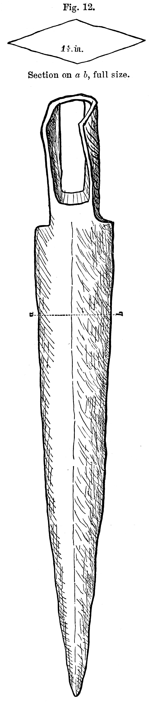 |
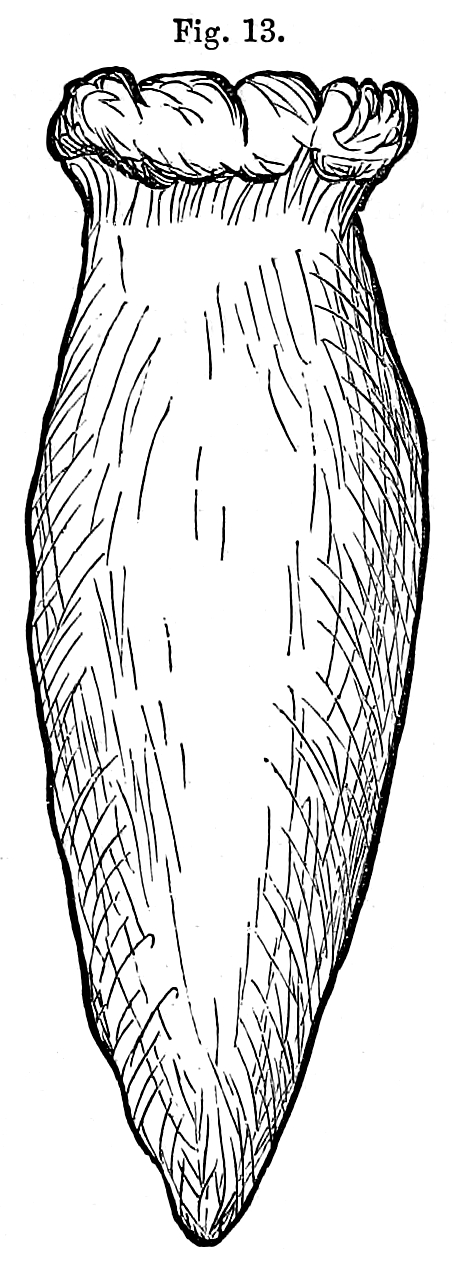 |
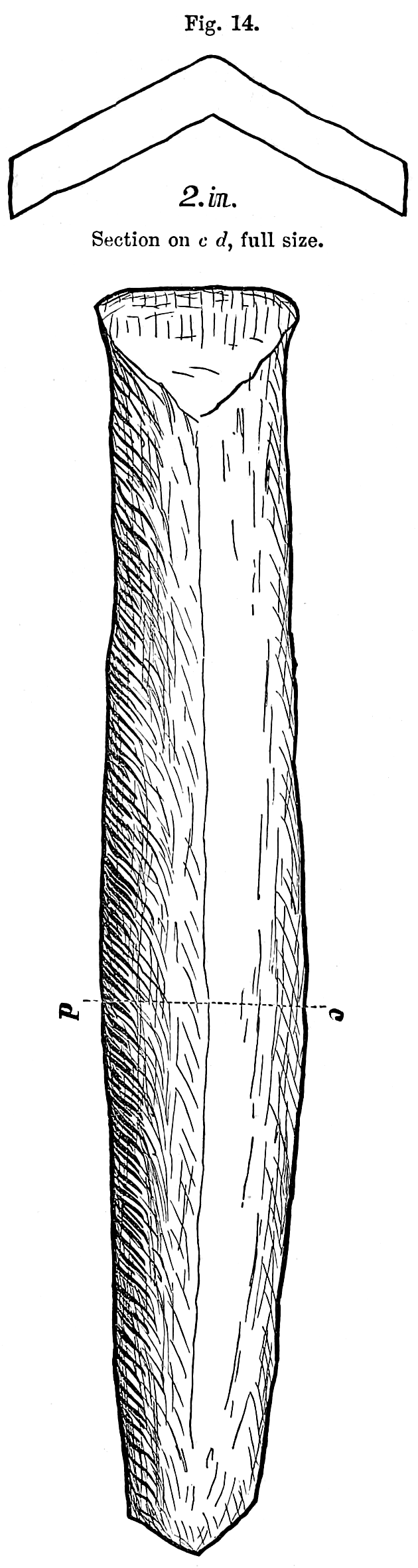 |
| Fig. 12. Spear Head.—Half size. 14 inches long. Ontonagon. From drawings of J E. Mullowney, Esq., Surveyor. | Fig. 13. Copper Gad, full size. Minnesota Mine. | Fig. 14. Chisel.—Half size. 13 inches long. Ontonagon. |
[pg 22] Copper Implements, Ontonagon.—Some laborers in the employ of Mr. Greenfield were levelling the ground for a brick yard on the east bank of the Ontonagon River, half a mile above the village, in the year 1854, when they perceived some pieces of copper, which were well fashioned implements. They are said to have been found upon a bed of clay in a ravine, and covered about two feet with alluvial earth, a large cedar tree growing nearly over the spot. They consist of two implements, which may be described as spear or javelin heads, though more probably designed as miners' tools; and two cutting instruments that may properly be called chisels, as shown in the annexed sketches. These show the form and size better than any written description. The socket of the spear is small, and not of the best shape to give a good fastening to a staff, which may perhaps favor the idea that it was a weapon for the use of one hand, like a dirk. The blade is symmetrical and strong; it apparently had not been much bruised or injured by use. If it was to be thrown like a javelin, the stock or staff must have been fitted on around the shank and driven down over the blade some distance, to make the wooden attach- ment proportionally strong with the metal part.
The chisel also had not been used, since neither the cutting edge nor the head is battered. It is bent up longitudinally from near each end in the manner shown by the cross section in c d. The object in giving it this form must have been to stiffen it and thus save metal. This contrivance speaks well for the ingenuity of the maker. Those instruments have better proportions than similar ones found in Ohio. They were probably fresh from the hands of the workman when they were lost upon the banks of the river. Although I have myself examined these implements, I am indebted to Messrs, Emerson, Coburn, and Mullowney for facts respecting them. Both are represented to be more hard and less malleable than the native copper of the mines, from which it has been inferred that they have undergone a hardening process. Like those found at Marquette and elsewhere, I suppose the hardness is due only to prolonged hammering, by which the density is increased. The copper of the ancient inhabitants of Europe was hardened by alloying it with tin.
 |
| Fig. 15. Pointed Tool with a Socket.—Full size. Carp River. |
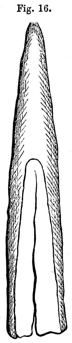 |
| Fig. 16. Rude Copper Knife.—Full size. Carp River. 1, 2. Spots of silver. |
The knife was harder than the chips, and does not bend so easily. This hardness is probably due to the process of hammering which the mass underwent while it was in a cold state, and not to any tempering. If the bodkin-like implement had not been of this parcel the others might have been referred to the present race of Indians. They possessed knives and other implements made of copper when the French came among them, but these were very rude. Mr. Baily, of Eagle Harbor, has one which resembles somewhat the semilunar knife used by saddlers. There is a notch in the middle by which to attach a handle. Mr. B. thinks it was used in dressing and working skins. It was found in the gravel within the pickets at Fort Wilkins, Copper Harbor.
Near the mouth of Carp River there are remains of cabins, placed in a row like the houses of a village. This is shown by a line of heaps of stone and clay, like the remains of chimneys, and connected with them slight ridges of clay, resembling the low embankments around a log building after the timber has decayed. They may have been formed of clay which was used to daub the chinks. A forest of ancient growth covered these ruins. Although I know of no historical evidence illustrating the point, I should hesitate to give them a greater antiquity than the early French adventurers. It is about two hundred years since the Jesuits established themselves on Lake Superior. Traders may have preceded them thirty years, and constructed cabins at places not mentioned by the Jesuits.
I have seen the ruins of buildings on the west fork of the Ontonagon, near the old Copper Rock, the history of which has reached us, and which were erected in 1769. In 1845, eighty-four years afterwards, all the logs except such as were of cedar, had disappeared. Near a cabin which [pg 24] was used for a blacksmith shop, the outlines of a forge were quite distinct, with cinders, charcoal, and pieces of rusty iron lying upon it. There were also several pounds of corroded steel and brass, mostly the locks and guards of muskets, and one gun barrel. On the forge a pine tree had established itself, which we cut down, and counted upon the stump sixty-one layers of annual growth.

Fig. 17. Copper Instrument,—Full size. Fort Wilkins.
In regard to the implements found at the mill on Carp River, I incline to the belief that they are not as ancient as the old mines. Mr. Henry, who has furnished us the account of the explorations just referred to on the Ontonagon River, and on the north shore, made by the English soon after the Treaty of Paris, says that the Indians beat out pieces of copper into bracelets and spoons. None of their implements are shown to have been so difficult to form as the chisels and spear-heads, which are found in the old pits. These required a state of mechanical skill apparently above the reach of Indians.
Mr. Burt has also furnished the following sketch of a copper hook found by himself in the excavation of the St. Mary's Canal.
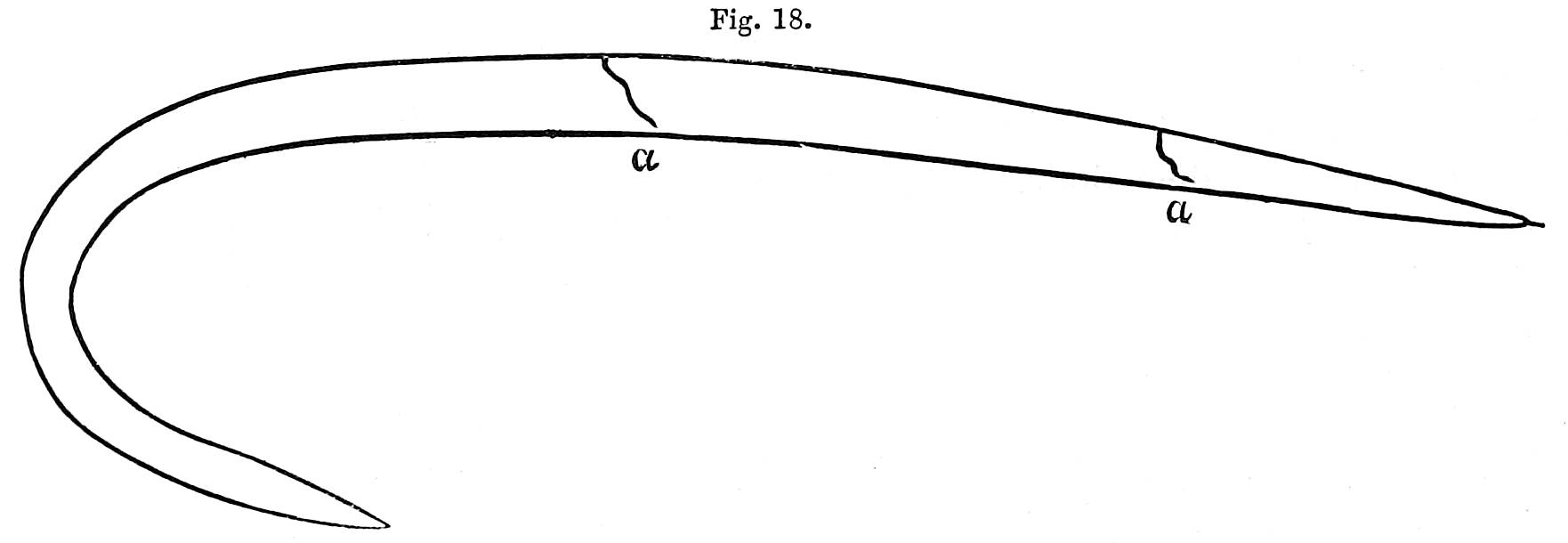
Fig. 18. Copper Hook.—Full size, a a. Flaws in the metal. Sault St. Mary's.
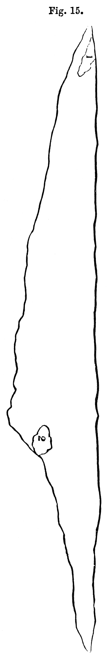
It has the usual flaws which cold wrought articles exhibit, and doubtless belongs to the class of recently made implements. [pg 25] On the Canada shore of the St. Mary's River, at Garden River, twelve miles below the Sault, an implement was discovered in the soil by a half-breed and presented to Mr. Burt. The horizontal and side views are sufficiently shown in the sketch to indicate its use, which was that of a cutting instrument like a chisel. Its bruised head shows the effect of blows from a mallet of wood or stone.
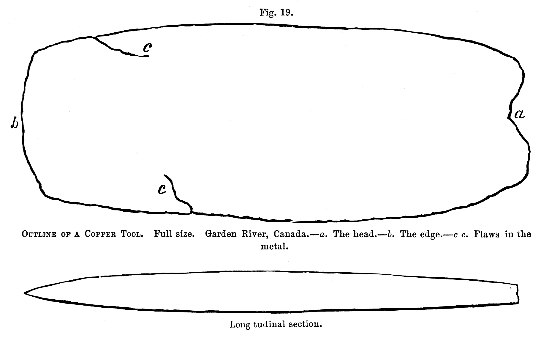
Fig. 19.
Outline of a Copper Tool. Full size. Garden River, Canada.—a. The head.—b. The edge.—c c. Flaws in the metal.
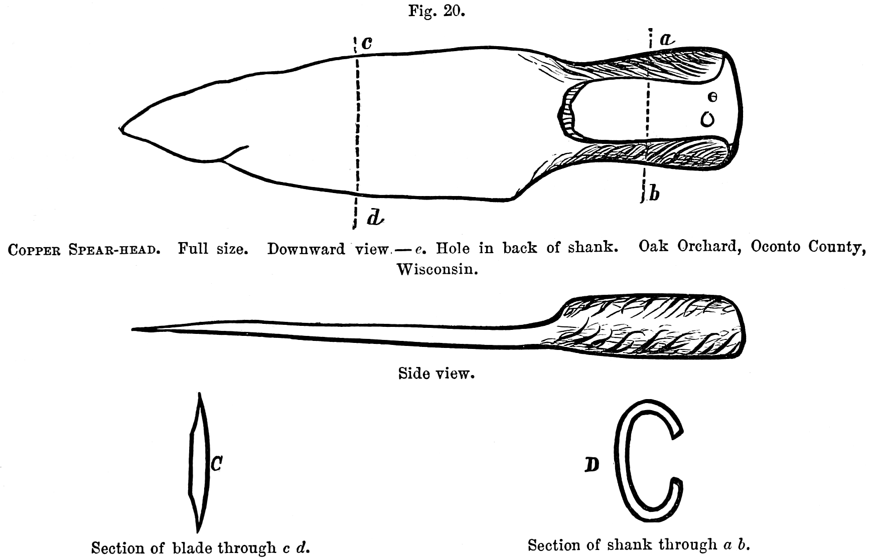
Fig. 20.
Copper Spear-head. Full size. Downward view—e. Hole in back of shank. Oak Orchard, Oconto County, Wisconsin.
[pg 26] A rude knife and spear-head of copper were recently picked up by Mr. William Windross, at Oak Orchard, Oconto County, Wisconsin, on the western shore of Green Bay. They are in the possession of Lyman C. Draper, Esq., of Madison, Wisconsin, to whom they were presented by the Hon. C. D. Robinson, of Green Bay. The spear or arrow-head differs from those of Lake Superior principally in the state of finish, and in having a hole e in the shank to fasten it to a handle or shaft. Both these specimens are roughly forged and apparently ground to a blunt edge. They are, with little doubt, recent, the work of some half-breed or Frenchman.
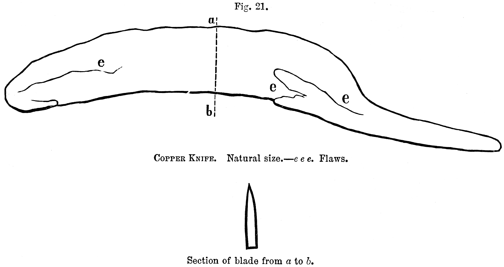
Fig. 21. Copper Knife. Natural size.—e e e. Flaws.
Section of blade from a to 6.
By whom were the ancient mines wrought?—I have already given reasons going to show that it was not the present Indian race by whom these mines were worked.
As yet no remains of cities, graves, domicils, or highways have been found in the copper region. As the race appears to have been farther advanced in civilization than their successors, whom we call the aborigines, they probably had better means of transportation than the bark canoe. They might thus carry provisions a great distance by water. Their mine-works are open cuts exposed to the day, which in the winter in this country, where snow lies from three to five feet in depth, could not be occupied comfortably without shelter. No remains of such coverings have been discovered, nor is it probable that any traces of such should now be recoverable. On the upland the thermometer descends to minus 38°. This would not fender these trenches absolutely untenable, but would present great difficulties in working them. Even in modern shafts and galleries, that are closed by self-shutting doors, frost penetrates to a depth of twenty and thirty fathoms. It is frequently necessary to put stoves in the upper levels in order to prevent their being filled with ice. It would therefore be barely possible, by no means profitable, to work in open trenches during winter. The miners could readily bring with them in the spring supplies for three months, and before these were exhausted the same craft might [pg 27] return for additional supplies. After spending the months of summer, the miners could return to their homes for winter, carrying with them the mineral obtained during the season.
In relation to their dead, it may have been a custom, perhaps a part of their religion, to restore the bodies to their friends. If the number of operators was not great, and the mortality was no greater than it is now, this would not have been a great burden. In case there were no women and children the proportional number of deaths would be less than at present. It is now, for the season of navigation, not far from five in 1000, including females and children, and including also those killed by accident.
All the ancient excavations hitherto examined could have been made, with our means of working, at less expense than has been incurred during the last ten years. But we must allow much for the imperfect modes of operating, and thus increase the number of men required to do the same work; we must also, on the other hand, conclude that the old mines were wrought a great length of time, and infer that a less mining force was kept up than we have in our times.
In the prosecution of mining in this remote region, not only would the deaths be few, but among them such distinguished persons as were entitled to sepulchral mounds or monuments would not be found in great numbers. The absence of artificial mounds, therefore, need not excite surprise.
The Mound Builders consumed large quantities of copper. Axes, adzes, chisels, and ornamental rings are so common among the relics in Ohio as to leave no doubt on this subject. We know of no copper bearing veins so accessible as those of Lake Superior to a people residing on the waters of the Ohio. Neither are there any others now known that produce native metal in quantities to serve as an article of commerce. Specimens of pure copper are found in other mines of North America, but not as a predominant part of the lode. The implements and ornaments found in the mounds are made of metal that has not been melted. They have been brought into shape cold wrought, or at least without heat enough to liquefy the metal, and were therefore produced from native copper. In the Lake Superior veins spots of native silver are frequently seen studding the surface of the copper, united or welded to it, but not alloyed with it. This is not known of any other mines, and seems to mark a Lake Superior specimen wherever it is found. It also proves conclusively that such pieces have not undergone fusion, for then the pure white spots would disappear, forming a weak alloy. Copper with blotches of native silver has been taken from the mounds. Dr. John Locke, of Cincinnati, possessed a flattened piece of copper weighing several pounds, which was found in the earthworks at Colerain, Hamilton County, Ohio, having a spot of silver as large as a pea forming a part of the mass.
At the first view of the logs which supported the mass m of the Minnesota vein, the marks of the tool by which they were cut brought to mind the old copper axes I had seen in Ohio, figured by Mr. Squier. The cut was about an inch and three-tenths wide, not smooth like that of a perfectly sharp edge, and not deep enough for a modem axe or hatchet. No such axes have been found on Lake Superior, Those of Ohio may have been used as a chisel, although Mr. Squier thinks a [pg 28] handle was attached to them. The difference between the axe and chisel is principally in the taper of the axe towards the head. No groove or eye has been noticed by which to insert a handle, but the Peruvians had means of fastening a handle to a similar instrument without either. There are also chisel-like tools from the Ohio mounds almost identical with those I have already figured. James McBride, Esq., of Hamilton, Butler County, Ohio, has in his possession four of them, found in 1855 near that place, that may be regarded either as chisels, axes, or adzes.
How much time has passed since these mines were wrought, or since they were abandoned, is a question of great interest. The timber found in some of the ancient mines is in a better state of preservation than that of the Ohio mounds; but it does not follow that it is more recent. Most of the pieces exhumed were covered by water, or wet earth. In a northern climate the decay of wood is slower than in warmer regions. The timber itself is mostly resinous, which assists in its preservation. The wooden cobwork that remains in the Ohio tumuli, hitherto examined, always lies above water, and the loamy earth in which it was buried does not wholly exclude the atmosphere.
In the Grave Creek mound the timber was very much decayed, but the chambers inclosing the skeletons were elevated above the natural surface, and the surrounding earth was dry. These circumstances being considered, it does not follow that the wood work of the mounds is the most ancient because it is the most decayed.
The living trees now standing, with their roots entwined among the mauls, skids, and shovels of the old miners, are reliable witnesses as to the least space of time since the mines were abandoned. The age of such trees varies from 300 to 350 years. Beneath the shade of these patriarchs of the forest are the prostrate and rotten trunks of a preceding generation.
General Harrison, in a discourse before the Historical Society of Ohio, adds another score to the tally of ages that have passed since the earthworks were evacuated. When ground that has been cleared of its timber is abandoned, the second growth differs from the first in kind. It is not until several generations of trees have disappeared, that such places produce the varieties which constituted the original forest. The same thing is observed on Point Keweenaw; where a sweeping fire has consumed or deadened the resinous trees of the mountains, the first succeeding growth is that of birch and aspen.
In process of time, however, the balsam, cedar, pine, and hemlock, resume their ancient domain, overshadowing and obscuring the deciduous trees. On the ancient burrows, and in the old pits of Lake Superior, the same kinds of timber flourish now as are observed in the surrounding forest. These works could not have been carried on without destroying the growth of timber of that day. Before the pines, and other evergreens that now occupy these places, overcame the birch and aspen trees, one or two generations must have passed away.
Is it going too far, on the strength of this evidence, to place the abandonment of the mines at a distance of 500 to 600 years from our times?
There may have been inhabitants covering large territories for long periods who have disappeared without leaving any monumental evidences of their occupation. [pg 29] If the North American Indians had been destroyed by a general pestilence before Pamphilo de Narvaez landed in Florida, what traces of them should we be able to Find? They have left no distinctive marks of their existence impressed upon the soil. Some faint signs of cultivation in the shape of little hillocks or hills of corn, not entirely obliterated as yet, are the sole vestiges of centuries. But avoiding all mere conjectural speculations, the following conclusions may be drawn with reasonable certaiaty:—
An ancient people extracted copper from the veins of Lake Superior of whom history gives no account.
They did it in a rude way, by means of fire and the use of copper wedges or gads, and by stone mauls.
They had only the simplest mechanical contrivances, and consequently penetrated the earth but a short distance. [Footnote: Their deepest works are about the same as that of the old tin mines of Cornwall, which were wrought before the conquest of Britain by the Romans.]
They do not appear to have acquired any skill in the art of metallurgy or of cutting masses of copper.
For cutting tools they had chisels, and probably adzes or axes of copper. These tools are of pure copper, and hardened only by condensation or beating when cold.
They sought chiefly for small masses and lumps, and not for large masses.
No sepulchral mounds, defences, domicils, roads or canals are known to have been made by them. No evidences have been discovered of the cultivation of the soil.
They had weapons of defence or of the chase, such as darts, spears, and daggers of copper.
They must have been numerous, industrious, and persevering, and have occupied the country a long time.
Eagle River, May 1, 1856.
PUBLISHED BY THE SMITHSONIAN INSTITUTION,
WASHINGTON, D. C.
APRIL, 1863
Copyright © 2005-2012 Calvin & Rosanna Hamilton. All rights reserved.