| Hastings Cutoff |
Trail Guide |
Salt Lake City |
Dead Man's Cave |
Benson's Mill |
Grantsville |
Timpie Point |
| Horseshoe Springs | Redlum Springs | Hastings Pass & Summit | West of Hastings Pass | I-80 | Evaporating Pond |
| Floating Island | Silver Island Point | Bomb Target | Donner Springs | Emigrant Graves | All Photos |
| Horseshoe Springs | Redlum Springs | Hastings Pass & Summit | West of Hastings Pass | I-80 | Evaporating Pond |
| Floating Island | Silver Island Point | Bomb Target | Donner Springs | Emigrant Graves | All Photos |
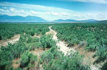 |
| This is the Hastings Trail north of Grantsville, the city is just above the upper center of the picture. |
The Museum is worth a visit to see the relics gathered from the Desert. Across the steet near the stop sign, is a obelisk with a plaque telling about the Fort built here in 1853. Cooley street was the center of the Fort. The 1856 GLO survey shows North Willow Creek which came down the valley from the mountains to the south an then apparently seeped into the ground in this area branching out to the east in two streams before it got to the fort and the third one ran right through the fort. This area where the steams branched out with all its willows is the approximate location of the camping ground on Willow Creek mentioned by the emigrants. The GLO map shows some 14 of Hastings wells in the area from the fort to almost a half mile east of the fort. The wells have since been filled in and very few remnants remain today. See the 1856 GLO Map of Grantsville & Twenty Wells.
CARLTON JONES in 1850 wrote in his journal:
"Monday [August] the 12'h traveled to willow Creek 25 miles passing many Springs Strongly impregnated with Salt[.] no good water until we got to willow Creek whare we found good water and grass[.] here we suppled ourselves with grass for the Great Desert[.]"
FINLEY McDIARMID on the 13th of august wrote to his wife in 1850:
"Ten or twelve miles from this place we reach Willow Creek. So called from the quantity of willows on the edge of the stream. This is the first pleasant pure fresh water since leaving the city. Roads dreadful dusty. Abundance of grass here and of an excellent quality. Plenty of dry willows for wood; this is quite a luxury. Passed four dead oxen. We camp upon the bank of this creek.
This was the first mention of dead animals after leaving Salt Lake City.
After visiting the Museum, continue west on Clark Street past the Grantsville Cemetery on the left. Drive 0.4 mile west on Clark Street from the museum until you come to the Lincoln Highway, turn right and drive on this road for 0.2 mile until you come to a right hand fork in the road which is 600 west street. Turn right and travel 0.9 mile to a road called Piccadilly or 800 north. Turn left and drive to the end of the gravel road by a white house. The owners have given us permission to park and walk to the willows to the west. The water in this area comes from two of the wells.
Turn around and drive back to the Lincoln Highway then turn right and travel 2.4 miles to a rail post marker which reads:
HASTINGS CUTOFF - TWENTY WELLS
"Morning cool and pleasant and we made and early start and travelled over a saleratus plain and around the spur of the mountain. ..."
Hugh Alexander Skinner, July 21, 1850
2000 Utah Crossroads Chapter - OCTA HU-8
This marker was placed next to this right of way fence and about 150 feet across the fence is the remains of the trail which was destroyed by the owners plowing up the ground three years ago. This was a pristine trail, part of which came from the bottom of the hill, out of the meadow land to the east, and the rest is the main trail heading onward.
Continue driving west. The gray house on your right sits right on the trail. Drive west until you come to a stop sign. Turn right, this is old U.S. 40 now U-138. Continue on this road. 0.5 mile to Bonneville Sea Base. The trail is on your right. When you come to the driveway to the hot springs you will note the trail on both sides of the fence. Carlton Jones is the only emigrant that mentions these hot springs:
"Tuesday the 13th left willow Creek and traveled west [northwest] and South [south after rounding Timpie Point] passing many large Boiling Springs verry strongly impregnated with Salt. Camped at the foot of mountain near an sulphur Spring [Big Springs] but little grass and no wood[.]"From the driveway of the hot springs, drive 0.4 mile to where the trail crosses the road to the left side because of the lower wet area. The trail continues at the edge of the wet area and crosses back over the road just south of a power pole, 0.5 mile. Continue a little farther to a metal gate in the fence on your right hand side. You need a key from an X road member to unlock the gate. Go through the gate, closing it, locking it then drive about 100 feet to the trail.
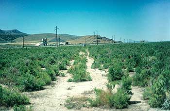 |
| This is the Hastings Trail near where U-138 turns to the north and joins up with I-80 at exit 84. This photo was taken when the trail was found in 1995. It is facing northwest and is approaching the Stansbury Mountains. The trail was located from a 1959 aerial photo. In this area there were four parallel tracks back to the southeast toward Twenty Wells [Grantsville]. R. Tea |
Drive down the trail which goes down a slight hill to the mud flats. You should note the tracks of the wagons in the mud. Continue on and look for where the trail splits and runs parallel to each other. You will come to some dirt berms, follow along the east side of the berm. This dirt berm was created to protect thousands of old tires which were stored here for years. The tires were removed just recently. Continue to the corner of the berm then drive a hundred feet or so on the north side of the berm until you come to the trail again. One can still see remnants of the trail on the inside of the berm where the tires were stored.
Continue on the trail. You will note that the trail splits into 4 parallel trails. Following the trail you will note where it comes back together or is just a wide single trail. You will come to another rail post marker, this one reads:
HASTINGS CUTOFF - DUSTY ROAD
"This is the most drying climate I ever was in. Got a late start, travelled 35 miles by a little after dark; very dusty road most of the way."
Henry S. Bloom, July 29, 1850"
2000 Utah Crossroads Chapter - OCTA HU - 9
Take the dirt road on the left and drive to the wire gate and close it after you. Turn right drive upon the paved road for 0.2 mile then turn left on Ellerbeck Road which was old US 40. The main U-138 curves to the right over the Hasting Trail. Note the trail continuing on northwest between the power poles. After turning left at the bend of U-138 onto old US-40, drive to the lime plant 0.4 mile for permission to continue on the trail. With permission, drive on the gravel road on the north side of the plant [which was the Lincoln Highway] and follow it to the right over a small hill. Drive down the hill and you will see the multiple trails on your right. Follow the trail to the next small hill where it crosses the road and stays close to the mountain. The road is blocked ahead so return on this gravel road to the plant and once again you come to the old pavement. Turn left.
Just on the north side of the small rock pinnacle on your left and across the railroad track, is the trail going right next to the pinnacle, on the north side, to avoid the wet area ahead. Continue on the pavement for 1.4 miles. You should be just opposite the Chemstar Lime Plant entrance [formerly the Dolomite Lime Plant]. This plant was built right on the trail some 65 years ago and has never been moved. Continue on for 0.6 mile where you will see a gravel road on you left. This road has a no trespassing & posted sign on it. With permission turn left 0.4 mile and drive up around the Springs to the right. This is Timpie Springs. The trail is on the south side of the spring. This Spring has been mistakenly called Big Springs, but we were corrected by an elderly Gentleman, named Myron Sutton, from Grantsville who stated that this spring is Timpie Spring.
The Lincoln Highway goes past the upper side of the spring and is the straight gravel covered road heading northwest. The gravel road you are on by the spring, is the Hasting Cutoff which has been extensively used and has had its pristine condition destroyed. From Timpie Spring follow the trail, or gravel road, for 3.8 miles where it avoids the wet marsh grass that the Lincoln Highway had to build a fill from one to two feet in order to cross. The trail also avoids most of the high sage brush with its thorns and stays right at the toe or foot of the Stansbury Mountains until it goes around Timpie Point and on a past Big Springs. The grass on the right side of the trail was burnt off in 2001 and the author drove between the trail and the Lincoln Highway several times and could not see any ruts nor evidence or indication of any other trail.
HEINRICH LIENHARD continues: "On the 14th of August we at last went on again. ... Our road led along the base of the mountains in a northerly direction a distance of ten or 12 miles, then we bent again to the left around the point of the mountain, thus leaving the Salt Lake to our right and gradually receding from it."
Following the gravel road one must be cautioned about driving on this road because of the deep holes that are full of water in the spring and early summer. A high clearance vehicle is recommended. When approaching the Lincoln Highway, look on the right side of the road where you will see a trail depression through some tall sage brush. This is a pristine section of the trail in this area. It is about 500 feet long. As the road goes around a point over some big rocks you can see the trail right at the toe of the mountain avoiding the rocks and on the edge of the marsh grass. This continues around the point to the next cove.
Do not try the above mentioned gravel road in wet weather, avoid the deep holes which would be full of water. Retrace your steps past Timpie Springs to Old US-40. Turn left on the pavement and go 3.0 miles to a turnoff on the left which will take you into another cove. As you turn left you will immediately cross the Lincoln Highway and right next to it is the Hastings trail through some marsh grass. This is a pristine trail which is perfect for 0.5 miles of hiking. As you hike the trail it leads out of the wet area on to the fringe of the grass and the sage brush. The trail is perfectly smooth with one big sage brush growing in the middle of it. Walking west you will see a white carsonite marker on the trail then the trail gradually curves to the right and heads directly for Timpie Point. In this area, on the bend, the author found a weathered barrel top.
The drivers and vehicles can continue on the gravel road 0.9 mile over to the point where the hikers can be picked up. The trail continued around Timpie Point probably on the edge of wet, marsh grass. The point has since been cut back to make room for Interstate 80. You will note a road going up over the point. THAT IS NOT THE HASTINGS CUTOFF TRAIL. Many trail buffs ask if that was the trail going over the point. It is not.