| Hastings Cutoff |
Trail Guide |
Salt Lake City |
Dead Man's Cave |
Benson's Mill |
Grantsville |
Timpie Point |
| Horseshoe Springs | Redlum Springs | Hastings Pass & Summit | West of Hastings Pass | I-80 | Evaporating Pond |
| Floating Island | Silver Island Point | Bomb Target | Donner Springs | Emigrant Graves | All Photos |
| Horseshoe Springs | Redlum Springs | Hastings Pass & Summit | West of Hastings Pass | I-80 | Evaporating Pond |
| Floating Island | Silver Island Point | Bomb Target | Donner Springs | Emigrant Graves | All Photos |
Note the odometer reading at the north, south gravel road then proceed westward. At -----miles you will come to a gate that could be open or closed. Keep going for ----- miles to another gate that is generally open. This gate is on the edge of a sand dune which could be soft or firm, in any case put your vehicle in four wheel drive and gun it over the dune. Continue on for -----miles to the next dune and follow the same advice. NOTE: this east west dike is south of the Air Force south Bombing Boundary. On the right or north side is the bombing range and on the left hand or south side is BLM Public Domain. Proceed for -----miles where the dike will make a 45 degree turn to the left. Keep going for ------miles to another bend in the dike. The dike is now heading south. Proceed for ----- miles to a point where I had placed a yellow carsonite on the trail before the water was pumped onto the flats.
The carsonite was on the left but is now gone. The cutoff trail is heading directly west from here toward Wendover. Being out here in the middle of nowhere will give you some idea of how the emigrants must have felt when they came through here during the day or at night.
Bryant again: "About eleven o'clock we struck A great white plain uniformly level, and utterly destitute of vegetation or any sign that shrub or plant had ever existed above the snow-like surface"
He said it was frightfully forbidding and unearthly, it gave them a shudder of apprehension, the mules even wanted to countermarch.
 |
 |
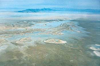
| This aerial photo shows the first playa. You can't see the trail but it goes diagonally from the lower right corner to the top left corner. | This photo shows the toxic waste dump, a full section-360 acres, it just misses the trail of the photo on the left center. |
 |
 |
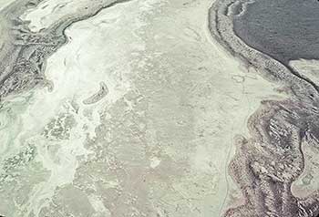
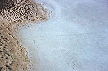
| This photo shows the first and second playa with a sand dune in-between. The trail goes across the tip of the small playa separating the sand dune and bends to touch the far side of the small sand island in the left center of the photo. | This is the sand dune separating the first two playas and shows the trail curving on the dune from the lower right center (note the faint line) to the left center of the photo. This photo shows the Hastings Cutoff curving across the sand dune between the first & second playa. It cuts across the south tip of a playa in the upper right hand corner. Arrows point to the trail curving from the right hand side of the photo to the left side. This is the only dune where you can see the trail from the air. The photo was taken in the fall of 1993 by the author. |
MISSING IMAGE: Bryant when out on the mud flats looks to his left (south) and notes a white mountain. This is the only white mountain out on the flats. It is south of the Knolls Railroad siding and the Interstate about 2 miles. It is made of small sand size gypsum crystals that have blown up on the side of the small mountain from off of the mud flats where the crystals formed .
Bryant continues: "For fifteen miles the surface of this plain is so compact, that the feet of our animals, as we hurried them along over it, left but little if any impression for the guidance of the future traveller."
 |
 |
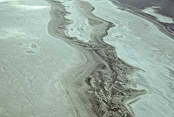
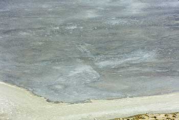
| This photo shows how the water backs up against the dunes during the wet season which would make it impossible to travel. | This is the beginning of the third playa and shows the plain trail coming off of the dune on the left and going across the playa in the right center. |
 |
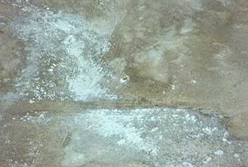 |
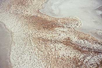
| This is the same trail as seen in image SIA3205 except the evaporation ponds in the 90's washed on the side of the dunes but the trail still shows up going west diagonally across the center of the photo. | This is the third playa and shows the trail plainly cutting across the photo from right to left just below the center of photo. |
Continue on this one vehicle wide dike to the south. At -----miles you will come to the Mag Corp. pump area. The canal they dug comes from the Air Force Bombing Range boundary to the north and keeps its direct bearing to the south with the vehicle dike now following on the east side. Continue travel until you come to the east west highway protection dike. From this point you have two choices: If you have a key to Mag Corp. lock you can proceed on east to the Mag. Corp. locked gate. If you can exit this way then you can enter the I-80 freeway at the Knolls Interchange. Drive west on I-80 to just past mile post 25 then turn right on to the Newfoundland Basin evaporation pond west dike. Drive north on the dike for 12 miles to Floating Island.
The second choice [if you have no key] is to either turn around and drive back the way you came to the north and east then south to the Knolls Interchange and on to I-80 or drive west on the highway protection dike. WARNING: This dike has very sharp fractured rocks which can puncture your tires especially if they are a low ply tire. If you feel you can take this dike road then drive about 17 ???? miles on the dike to the west but be warned. When you get to the west dike you can now travel 12 miles to Floating island.