| Hastings Cutoff |
Trail Guide |
Salt Lake City |
Dead Man's Cave |
Benson's Mill |
Grantsville |
Timpie Point |
| Horseshoe Springs | Redlum Springs | Hastings Pass & Summit | West of Hastings Pass | I-80 | Evaporating Pond |
| Floating Island | Silver Island Point | Bomb Target | Donner Springs | Emigrant Graves | All Photos |
| Horseshoe Springs | Redlum Springs | Hastings Pass & Summit | West of Hastings Pass | I-80 | Evaporating Pond |
| Floating Island | Silver Island Point | Bomb Target | Donner Springs | Emigrant Graves | All Photos |
Continuing down the road for 0.6 mile, stop and notice the trail depression on the left. This road obliterated most of the trail down to and just beyond the Railroad.
HEINRICH LIENHARD tells about traveling down from Hastings Pass:
"... a boundless flat plain lying before us, an oppressive solitude as silent as the grave. The soil was composed of sand and gravel [Aragonite Road], from which nothing but small, thorny shrubs, grease wood, perhaps 1 l/2 feet high, eked out a miserable existence. Neither wolf nor antelope nor any other animal was to be seen or heard; however, lying scattered over the ground were the bones and gigantic horns of fallen mountain sheep and a few elk. The longer we continued on over the dusty, sandy road down toward the desolate plain, the darker it became. No sound was perceptible except our own muffled footfalls in the loose sand, which had been made unstable by the wagons and the hoofs of the livestock in advance of us. One behind the other, like so many recruits learning to march, we strode along without speaking. . . ."
MISSING IMAGE: Trail depression west of Hastings Pass (in background). There was a fire burn in Hastings Pass and to the west in 1995. This photo was taken on November 22, Looking east, OCTA members Oscar Olson in foreground and Vern Gorzitze in back. Aragonite mining operations destroyed most of trail down to their plant at the railroad n the 1900's. R. Tea.
 |
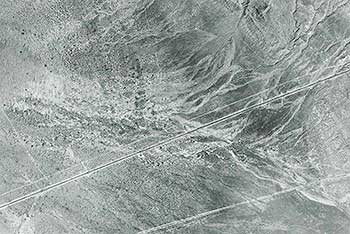 |
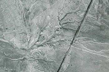
| This is an aerial photo of the trail crossing some washes at the end of the Grassy Mountain Range. The trail is the white line going from lower right to the center left. The dark line is the Western Pacific Railroad and the Aragonite Plant where it crosses the trail. The line from the top center down to the trail is the Victory Highway where it traveled on the trail for a short distance. | This aerial photo has the Trail cutting from lower right to center left of the photo. The white line running diagonally at the bottom is the Victory Highway of the 1920's the dark line is old US 40 before I-80 was built. |
Continuing our tour, at 1.6 miles you should come to a north-south paved road and on our left is the CLEANHARBORS burn plant. This plant burns toxic waste material such as PCB, paint, etc. Turn right on the asphalt pavement and travel north until you come to a railroad crossing and then at 2.1 miles a frontage road on your left. Turn left on the frontage road and travel 2.3 miles to where the road turns to the south. Across and on the west side of the road is a gate, go through it and pass the pump house and watering troughs, following the vehicle tracks down to the old Victory Highway then turn right on this barely visible road. Follow the road which will turn left then continue on until the road comes into the Hastings trail. Turn left to the berm of the hill by a carsonite marker. Exit the vehicles and look down into the washes where the trail comes across. It appears that the trail across the washes has not been used since it was abandoned after 1850.
Mount the vehicles and turn around then drive west on the south side of the trail. The Victory road used the trail for a short ways then headed directly west to Knolls. The Cutoff Trail after it goes around the rock point, turns to the northwest where it will cross I-80. Since there is no access to I-80 we must turn around and follow the tracks back past the pump building.
The fresh water from this 400 foot deep well is used for the Grassy Mountain Rest Area and is the only good water between Hope Wells and Pilot Springs. Follow the frontage road back to the Burn Plant Road then turn left and drive over the structure and take the west bound on ramp and drive west to the rest area on your right for a needed rest break.
 |
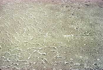 |
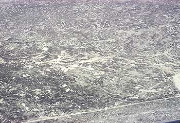
| The trail runs diagonally across the photo from the white spot on the lower right to the center on the left. The dark line on the lower right corner is US 40. | The trail goes across the center of this photo from right to left. |