

JEFFERSON COUNTY.
THIS county is bounded on one side by Lake Ontario, and upon the other by the wild, mountainous region which separates the waters of the Hudson River from those of the St. Lawrence. It is intersected by the Black River, one of the most picturesque streams of the State. Its surface is diversified: for about ten miles back from the shores of the lake, it is nearly level; we then reach the ledges of the Trenton limestone, and the entire country becomes more elevated and irregular. These natural features, implying an abundance of fish and game, joined to great fertility of soil and easy cultivation, fitted this county for sustaining a large aboriginal population. We are not surprised, therefore, at finding here numerous traces of former occupancy. 'These consist chiefly of enclosures of irregular outlines, situated, for the most part, upon the borders of the high table-land or terrace formed by the abrupt termination of the great limestone deposit of the Trenton group, the base of which, it is supposed, was formerly washed by the waters of Lake Ontario. Quite a number of these works, however, occur upon the lower terrace, in places where the natural features of the ground were favorable to their construction and objects. Works were examined in this county, in the townships of Watertown, Le Ray, Rutland, Rodman, Adams, and Ellisburgh. The following examples are presented in the order in which they were surveyed.
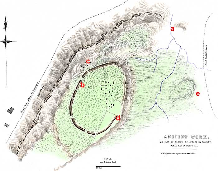
PLATE I.
ANCIENT WORK, ADAMS TOWNSHIP, JEFFERSON COUNTY, NEW YORK.
THIS work occupies a commanding position upon the brow of the second terrace, which is here some hundreds of feet in height, and very abrupt. The ground immediately back of the site of the work is considerably depressed and swampy. It is drained by a little stream (a), which, falling over the cliff, forms a small but picturesque cascade. The narrow channel of this stream was formerly obstructed by a beaver-dam, which converted the marsh into a deep and impassable pond. The elevation upon which this work is situated, it will thus be seen, was well fitted by nature for defensive purposes, possessing the two primary requisites, difficult approach and an unfailing supply of water.
The artificial defences consist of an embankment of earth, with an exterior ditch. The forest covers the greater part of the work, and here the lines are still well preserved. The embankment has an average height of perhaps three feet, by ten feet in width at the base; the ditch is of corresponding dimensions. There are not less than seven gateways, varying from eight to thirty feet in width. Upon the right of the work, towards the swamp already mentioned, there is an abrupt bank not far from thirty feet in height, where the defences are interrupted. At the point indicated by the letter b, a large bass-wood (linden) tree is standing upon the embankment. It measures twelve feet in circumference, three feet above the ground. The trees within the enclosure are of the usual size.
Upon the northeastern slope of the eminence, within the walls of the enclosure, and where the soil is sandy and dry, are a great number of small pits and depressions in the earth. They are now nearly filled by accumulations of leaves, but they must at first have been from four to six feet in depth. Upon excavating some of them, it was found that they were the caches in which the former occupants of the work had placed their stores.1 And although it seems probable the original deposits had been removed, considerable quantities of parched corn, now carbonized by long exposure, were still to be found within them. There were, perhaps, forty or fifty of these excavations within the walls, and several upon the crown of the eminence at c.
Upon removing the leaves at various points within the work, carbonaceous accumulations, bones of animals, fragments of pottery, and other evidences of occupation were discovered. A small portion of the work, indicated on the map, has been cleared and put under cultivation. Here, just exterior to the wall, upon the brow of the natural bank, at the spot marked d, several skeletons have been exhumed by the plough. They had been buried in a sitting posture, and were very well preserved.
By the operation of diluvial causes, the drift has been deposited, in a very singular manner, upon the table-land upon which the above work is situated. In some places it occurs in long, narrow ridges, conforming to the general course of the terrace bank; in others it forms amphitheatres of various sizes; and in a few instances it assumes a conical shape, resembling artificial tumuli. A short distance to the right of the work under notice is a small natural amphitheatre, rising in the midst of the marshy grounds, which has been supposed by some to be artificial. Its relative position is indicated by the letter e.
About one and a half miles southeast of the above work, was formerly another of perhaps larger size. It occupied a high, oval-shaped hill, one side of which is very steep, while the other subsides gently to the general level. The embankment extended in a semicircular form around that part of the hill not protected by nature; and, previous to the cultivation of the ground, was upwards of six feet in height from the bottom of the trench. A very slight depression, and the greater luxuriance of the verdure, resulting from the filling of the trench with surface loam, are all that now indicate the original lines. It is said that there was an avenue leading off, for some distance, to the westward; but it is no longer traceable. At the base of this hill is a boulder, in which are several artificial depressions, doubtless intended for mortars, and a variety of grooves, in which the stone axes and other implements of the aborigines were rubbed, in order to reduce them to the required shape.
1. The term cache, literally a hide or place of concealment, is of French origin, and has become current amongst all the traders and trappers on the frontiers. The practice of caching or hiding goods or provisions on outward marches, to be used upon returning, or by parties following, was derived from the Indians, among whom it was general. A cache is made by digging a hole in the ground, which is lined with sticks, grass, or any material which will protect the contents from the dampness of the earth. After the goods or provisions have been deposited, the earth is carefully covered over, so as to best prevent the penetration of water from above. "It is often, in fact always necessary, at the West, to leave no signs by means of which rival parties or the cunning savages may discover the place of deposit. To this end the excavated earth is carried to a distance, and carefully concealed, or thrown into a stream, if one is near. The place selected is usually some rolling point, sufficiently elevated to be secure from inundations. If it be well set with grass, a solid piece of the turf of the size of the proposed excavation is cut out. It is afterwards laid back, and taking root in a short time, no signs remain of its ever having been molested. However, as every locality does not afford a turfy spot, the campfire is sometimes built upon the place, or the animals are penned over it, which effectually destroys all trace of the disturbance."—(Gregg's Commerce of the Prairies, vol. i. p. 69.) Father Hennepin, in his account of his passage down the Mississippi River, in 1680, describes an operation of this kind in the following terms: "We took up the green sod, and laid it by, and digged a hole in the earth, where we put our goods, and covered them with pieces of timber and earth, and then put in again the green turf: so that it was impossible to suspect that any hole had been digged under it, for we flung the earth into the river."
Copyright © 2009 Calvin & Rosanna Hamilton. All rights reserved.