

APPENDIX.
ANCIENT WORKS IN PENNSYLVANIA AND NEW HAMPSHIRE.
WITHOUT the boundaries of the State of New York, there are works composed of earth, closely resembling those described in the preceding pages. Among these may be named the small earth-works of Northern Ohio, which the author himself was at one time led to believe constituted part of the grand system of the mound builders.19 The more extensive and accurate information which he has now in his possession concerning them, as also concerning those of Western New York, has led to an entire modification of his views, and to the conviction that they are all of comparatively late date, and probably of common origin.Some similar works are said to occur in Canada; but we have no account at all satisfactory concerning them. One is mentioned by Laing (Polynesian Nations, p. 109) upon the authority of a third person, as situated upon the summit of a precipitous ridge, near Lake Simcoe, and consisting of an embankment of earth, enclosing a considerable extent of ground. Mr. Schoolcraft also states that there are some ancient enigmatical walls of earth in the vicinity of Dundas, which extend several miles across the country, following the leading ridges of land. These are represented to be from five to eight miles in length, and not far from six feet high, with passages at intervals, as if for gates (Oneota, p. 326). Our knowledge concerning these is too limited to permit any conjecture as to their design.
In the State of Pennsylvania, there are some remains, which may be regarded as the "outliers" of those of New York. They are confined to the upper counties. Those in the Valley of Wyoming are best known. They have, however, been lately so much obliterated, that it is probable they can be no longer traced. One of the number was examined and measured in 1817 by a gentleman of Wyoming, whose account is published by Mr. Miner, in his "History of Wyoming."
"It is situated in the town of Kingston, Luzerne county, upon a level plain, on the north side of Toby's Creek, about one hundred and fifty feet from its bank, and about half' a mile from its confluence with the Susquehanna. It is of an oval or elliptical form, having its longest diameter from northeast to southwest, at right angles to the creek. Its diameters are respectively 337 and 272 feet. On the southwest side appears to have been a gateway, twelve feet wide, opening towards the great eddy of the river into which the creek falls. It consisted of a single embankment of earth, which in height and thickness appears to have been the same on all sides. Exterior to the wall is a ditch. The bank of the creek upon the side towards the work is high and steep. The water in the creek is ordinarily sufficiently deep to admit canoes to ascend to the fortification from the river. When the first settlers came to Wyoming, this plain was covered with its native forests, consisting principally of oak and yellow pine; and the trees which grew upon the work are said to have been as large as those in any part of the valley. One large oak, upon being cut down, was found to be 700 years old. The Indians have no traditions concerning these fortifications; nor do they appear to have any knowledge of the purposes for which they were erected."—(Miner's History if Wyoming, p. 25.) Traces of a similar work existed on "Jacob's Plains," on the upper flats of Wilkesbarre. "It occupied the highest point on the flats, which in the time of freshets appears like an island in the sea of waters. In size and shape it coincides with that already described. High trees were growing upon the embankment at the period of the first settlement of the country. It is about eighty rods from the river, towards which opened a gateway; and the old settlers concur in stating that a well [cache ?] existed in the interior near the southern line. On the banks of the river is an ancient burial-place, in which the bodies were laid horizontally in regular rows. In excavating the canal through the bank bordering the flats, perhaps thirty rods south of the fort, another burial-place was disclosed, evidently more ancient, for the bones crumbled to pieces almost immediately upon exposure to the air, and the deposits were far more numerous than in that near the river. The number of skeletons are represented to have been countless, and the dead had been buried in a sitting posture. In this place of deposit no beads were found, while they were common in the other."—(Miner's History, p. 28.)
Near this locality, which seems to have been a favorite one with the Indians, medals bearing the head of the First George, and other relics of European origin, are often discovered.
Still further to the northwest, near the borders of New York, and forming an unbroken chain with the works of that State, are found other remains. One of these, on the Tioga River, near Athens, was ascribed by the Duke de Rochefoucauld to the French, in the time of De Nonville! He describes it as follows: "Near the confines of Pennsylvania, a mountain rises from the banks of the River Tioga, in the shape of a sugar loaf, upon which are to be seen the remains of some entrenchments. These are called by the inhabitants the 'Spanish Ramparts,' but I judge that they were thrown up against the Indians, in the time of De Nonville. A breast-work is still remaining."—(Travels in America.) A similar work, circular or elliptical in outline, is said to exist in Lycoming county. Near it are extensive cemeteries.—(Day's Hist. Coll., p. 455.)
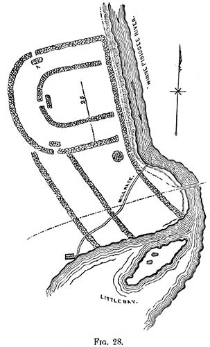
In the New England States few traces of works of this kind are to be found. There are, however, some remains in the State of New Hampshire, which, whatever their origin, are entitled to notice. The subjoined plan of one of these is from a sketch made in 1822 by Jacob ll. Moore, Esq., late Librarian of the Historical Society of New York, who has also furnished the accompanying description.
 "According to your request, I send the enclosed sketch and memoranda of an
ancient fortification, supposed to have been the work of the Penacook Indians, a
once powerful tribe, whose chief seat was in the neighborhood of Concord, New
Hampshire. The original name of the town was derived from that of the tribe.
The last of the Penacooks long since disappeared, and with them have perished
most of the memorials of their race. Enough has come down to us, however, in
tradition, added to the brief notes of our
historians, to show that the Penacooks were
once a numerous, powerful, and warlike
tribe. Gookin places them under the general division of the Pawtucketts, which he
calls 'the fifth great sachemship of Indians.'20 Under the name of Penacooks,
were probably included all the Indians inhabiting the valley of the Merrimack, from
the great falls at the Amoskeag to the Winnepiseogee Lake, and the great carrying
place on the Pemigewasset. That they were
one and the same tribe, is rendered probable from the exact similarity of relics, which
have been found at different places, and
from the general resemblance of the remains
of ancient fortifications, which have been
traced near the lower falls of the Winnepiseogee, in Franklin and Sanbornton, and on
the table-land known as the Sugar-Ball
Plain, in Concord. Tradition ascribes to
each the purpose of defence against a common enemy, the Maquaas or Mohawks of
the west.
"According to your request, I send the enclosed sketch and memoranda of an
ancient fortification, supposed to have been the work of the Penacook Indians, a
once powerful tribe, whose chief seat was in the neighborhood of Concord, New
Hampshire. The original name of the town was derived from that of the tribe.
The last of the Penacooks long since disappeared, and with them have perished
most of the memorials of their race. Enough has come down to us, however, in
tradition, added to the brief notes of our
historians, to show that the Penacooks were
once a numerous, powerful, and warlike
tribe. Gookin places them under the general division of the Pawtucketts, which he
calls 'the fifth great sachemship of Indians.'20 Under the name of Penacooks,
were probably included all the Indians inhabiting the valley of the Merrimack, from
the great falls at the Amoskeag to the Winnepiseogee Lake, and the great carrying
place on the Pemigewasset. That they were
one and the same tribe, is rendered probable from the exact similarity of relics, which
have been found at different places, and
from the general resemblance of the remains
of ancient fortifications, which have been
traced near the lower falls of the Winnepiseogee, in Franklin and Sanbornton, and on
the table-land known as the Sugar-Ball
Plain, in Concord. Tradition ascribes to
each the purpose of defence against a common enemy, the Maquaas or Mohawks of
the west.
"The accompanying sketch was taken in pencil, on a visit to the spot, in company with the Hon. James Clark and several friends in the month of September, 1822. The remains are on the west side of the Winnepiseogee, near the head of Little Bay, in Sanbornton, New Hampshire. The traces of the walls were at that time easily discerned, although most of the stones had been removed to the mill-dam near at hand, on the river. On approaching the site, we called upon a gentleman (James Gibson) who had lived for many years near the spot, and of whom we learnt the following particulars: He had lived in Sanbornton fifty-two years, and had known the fort some time previous to settling in the place. When he came to the town to reside, the walls were two or three feet high, though in some places they had fallen down, and the whole had evidently much diminished in height, since the first erection. They were about three feet in thickness, constructed of stones outwardly, and filled in with clay, shells, gravel, &c., from the bed of the river and shores of the bay. The stones of which the walls were constructed were of no great size, and such as men in a savage state would be supposed to use for such a purpose. They were placed together with much order and regularity, and when of their primitive height, the walls must have been very strong-at least, sufficiently strong for all the purposes of defence against an enemy to whom the use of fire-arms was unknown.
"The site of the fortification is nearly level, descending a little from the walls to the bank of the river. West, for the distance of nearly half a mile, the surface is quite even. In front or east, on the opposite side of the river, are high banks, upon which at that time stood a thick growth of wood. When the first settlers discovered the fort, there were oak trees of large size standing within the walls. Within the enclosure, and in the mound and vicinity, were found innumerable Indian ornaments, such as crystals cut into the rude shapes of diamonds, squares, pyramids, &c., with ornamental pipes of stone and clay,—coarse pottery ornamented with various figures,—arrow-heads, hatchets of stone, and other common implements of peace and war.
"The small island in the bay appears to have been a burial-place, from the great quantity of bones and other remains disclosed by the plough, when settlements were commenced by the whites. Before the island was cultivated, there were several large excavations, resembling cellars or walls discovered, for what purpose constructed or used, can of course only be conjectured. There is a tradition that the Penacooks, at the time of their destruction by the Maquaas, had three hundred birch canoes in Little Bay.
"After writing thus far, I addressed a note to the Hon. James Clark, of Franklin, New Hampshire, with inquiries as to the present state of these ruins. Mr. Clark was kind enough at once to make a special visit to the site of the ruins, in company with Mr. Bamford, son of one of the first settlers. The following is an extract from his reply:
"'The remains of the walls are in part plainly to be traced; but the ground since our former examination has been several years ploughed and cultivated, so as to now give a very indistinct view of what they were at our previous visit, when the foundation of the whole could be distinctly traced. No mounds or passage-ways can now be traced. A canal to convey water to a saw and grist mill occupies the place of the mound marked m. The stones used in these walls were obtained on the ground, and were of such size as one man could lift; they were laid as well as our good walls for fences in the north, and very regular; they were about three feet in thickness and breast high when first discovered. The stones have been used, to fill in the dam now adjoining. There were no embankments in the interior. The distance between the outer and inner wall was about sixty feet; the distance from the north to the south wall was about 250 feet, and from the west wall to the river about 220 feet. There were two other walls extending south to Little Bay. The general elevation of the ground was about ten feet above, and gently sloping to the river bank, which is about five feet above the water of the river. The distance between Great Bay and Little Bay is about 160 rods, with a gradual fall of fifteen feet. Here was a great fishing-place for the Indians.' Mr. Bamford states that he has heard his father and Mr. Gibson say, that on their first acquaintance with this place, they have seen three hundred bark canoes here at a time. This may have been in consequence of the number of bays and lakes near this place. Sanbornton was laid out and surveyed in 1750; but Canterbury, adjoining the bay, was settled as early as 1727.
"The remains of a fortification, apparently of similar construction to that above described, were some years since to be seen on the bluffs east of the Merrimack River, in Concord, on what was formerly known as Sugar-ball Plain. The walls could readily be traced for some distance, though crumbled nearly to the ground, and overgrown with large trees."21
19. Ancient Monuments of the Mississippi Valley.
20. Gookin, in l. Mass, Hist, Coll., I., 149,
21. "A mound 45 or 50 feet in diameter is situated on the northern shore of Ossipee Lake, New Hampshire. It is ten feet high, and was originally covered with timber. The earth is not like that of the meadow in which it stands, but of the adjacent plain. A slight excavation was made in it a number of years ago, in the course of which three entire skeletons were found, accompanied by two tomahawks and some coarse pottery. On the surrounding meadow were to be seen, when the ground was first cleared, the hills where the corn had anciently grown."—Hist. and Mis. Coll. of N. H., Vol. II., p. 47: New Hampshire Gazetteer, p. 207.
Copyright © 2010 Calvin & Rosanna Hamilton. All rights reserved.