

PLATE XXVII.
The Portsmouth Works, Scioto County, Ohio.
[Most of this site has been destroyed, but one of the horseshoe mounds has been preserved.]
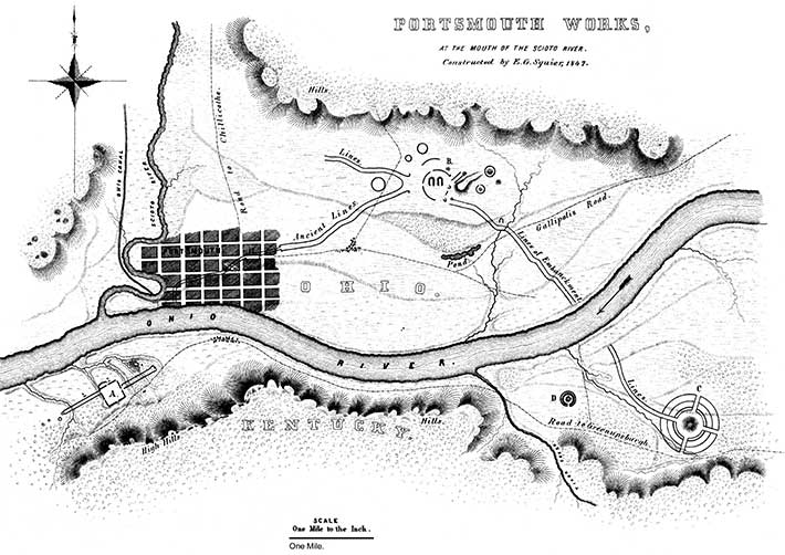
THE beautiful plain at the confluence of the Scioto and Ohio rivers, where now the flourishing town of Portsmouth is located, forms the site of a singular and interesting series of works. It has been preferred to present them together, as they seem to be intimately connected, leaving the reader to form his own conclusions respecting them.
The works consist of three divisions or groups, extending for eight miles along the Ohio river, and are connected by parallel lines of embankments. Two of these groups are on the Kentucky side of the river; the remaining one, together with the larger portion of the connecting embankment, on the Ohio shore. A reference to the accompanying map, exhibiting a section of eight miles of the Ohio valley, will show the relative positions and general plan, though not the exact proportions of the series. The avenues or "covered ways," extending from one work to the other, have induced many persons to assign them a military origin, and a design to protect communication between the groups. But unless the work at A be regarded as a work of defence, it is very certain that we must seek for some other explanation of their purposes. These avenues constitute a remarkable feature; and as enlarged plans and full descriptions of the several groups follow, it may be well to notice them more particularly here. It will be seen that from the central group B, three lines lead off: one to the south-east, to a point on the Ohio, nearly opposite to which, on the Kentucky side, it is resumed, leading to the circular work C; another bears south-west, to a point on the river, nearly opposite the large and regular work A. It does not appear to be resumed on the other side of the river. A third line runs north-west for a considerable distance, and loses itself in the broken grounds towards the Scioto. It may have communicated with other works in that direction, which have been obliterated by time, or, which is most likely, were destroyed in the manifest changes which the plain in that direction has undergone within a few centuries.
These lines consist of parallel embankments of earth, now measuring about four feet in height, by twenty feet base. They are not far from one hundred and sixty feet apart. The line leading towards the mouth of the Scioto, however, at about midway of the distance, suddenly contracts to seventy feet. It is said to have as suddenly widened further on, enclosing a square area, with a gateway opening to the north. The town of Portsmouth is built over this portion, and all traces of the parallelogram and the walls have disappeared. Near the point of contraction in this line are two or three mounds of medium size.
It is a fact to be observed in these as in similar lines at other places, that they are not interrupted by the inequalities of the ground, but conform to the undulations of the surface, running sometimes at right angles to the terrace banks, and sometimes diagonally up and down them. At some points these banks are very steep,—so steep, indeed, that in clambering up them the explorer is inclined to doubt that they were ever used or intended for purposes of communication. The only interruptions are those caused by the passage of streams, there being no gateways observable. The total length of the parallels now traceable may be estimated at eight miles, giving sixteen miles of embankment to the parallels alone. If we include the walls of the entire series, we have a grand total of upwards of twenty miles.
After this general view, the reader will be prepared to examine the groups forming the series A, B, and C, in the order of their succession.
Copyright © 2009 Calvin & Rosanna Hamilton. All rights reserved.