

PLATE XXIII. No. 1.52
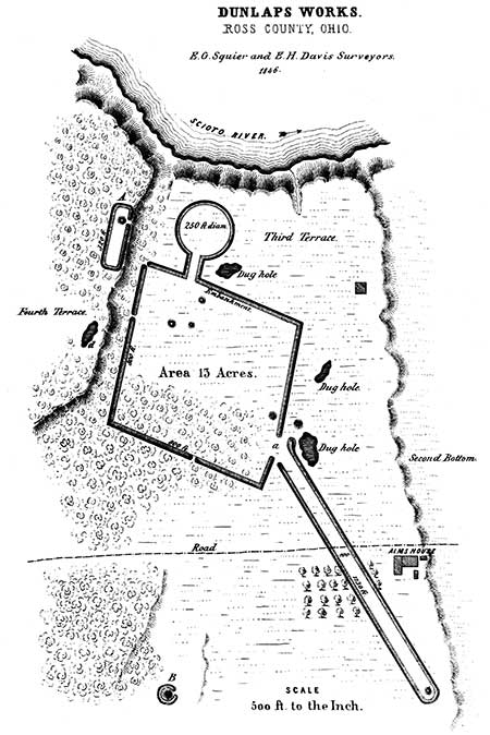
Dunlap's Works, Ross County, Ohio.
[This site has been completely destroyed.]
THIS work, situated on the right bank of the Scioto river, six miles above Chillicothe, presents some remarkable features. It is rhomboidal in figure, with an avenue eleven hundred and thirty feet long extending to the south-east, and also a short avenue, leading from a gateway to the north, connecting with a small circle. Along the western wall runs the bank of a plain, elevated a number of feet above the level of the work, upon the very brow of which is situated an outwork (A) eighty feet wide by two hundred and eighty in length. It overlooks the larger work, and has a wide gateway opening towards it. At this point the bank seems to have been graded to a more gentle descent. The great avenue approaches to within sixty feet of the gateway at a, which is one hundred and twenty feet wide; the walls closing, at the other extremity, upon a radius of half the width of the avenue. A low mound occupies the extreme point of the avenue. At some distance south of the main work, is a mound surrounded by a ditch and low embankment; and at the distance of about half a mile, very nearly in the course of the avenue, are a number of mounds,—one of which is fifteen feet high, truncated, and with a base of one hundred feet diameter. The diameter of the level area on the top is about fifty feet. These mounds stand on the lowest portion of the second terrace; the ground which they occupy being overflowed at periods of very high water in the river. These are the only monuments known which are reached by overflows. The top of the truncated mound was made a place of refuge, during the high water of 1832, by a family, with their cattle, horses, etc., numbering in all nearly a hundred. It was among the first opened, in the progress of these investigations, and before the characteristics of this class of works were clearly known. Hence, although a number of skeletons were disinterred, at depths of from two to five feet, together with a few rude instruments, the original deposit of the mound-builders was not reached. The skeletons were unquestionably those of the modern Indians. Upon the mound and around it, many fragments of rough pottery are found, and a number of entire vases of rude workmanship were exposed a few years since in ploughing over an adjacent small mound. Many decayed fresh-water shells are also found on and around the mound; and, as these when pulverized entered into the composition of the rude pottery of the more recent Indians, it seems highly probable that a sort of manufactory of this ware was established here. A number of large mounds also occur at some distance to the northward of the principal work.
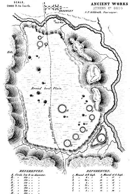
PLATE XXIII. No. 2.
Ancient Works, Athens County, Ohio.
FOUR miles north of the town of Athens, Athens county, Ohio, is a broad and level Plain, Upon which is situated a large group of ancient earthworks. The accompanying plan and description were furnished by S. P. HILDRETH, M. D., of Marietta, Ohio.53"The plain upon which these remains occur is not far from a mile and a half long, by a mile and a quarter broad, and contains upwards of one thousand acres. The soil is a sandy argillaceous earth, easily tilled and quite fertile. At the northern extremity of the plain is the village of Chauncey, where are located several salt factories, which are supplied by some of the most abundant saline waters in the State of Ohio. The plain has an elevation of sixty or seventy feet above the present bed of the Hocking river, and was evidently formed when its waters flowed at a higher level. This stream now runs from half a mile to a mile to the eastward of the plain, separated from it by low hills. All around the margin of the plain, where not bordered by hills, burst forth copious springs of fresh water, which are most abundant in the vicinity of the principal ancient works. Most of these works occupy the south-eastern portion of the plain. They consist of a number of small circles, accompanied by mounds, the several dimensions of which are given in the accompanying plan. The largest circle is situated upon a detached point of land, of the same level with the adjacent plain, from which it is cut off by a deep ravine, in which flows a small stream. This detached portion contains not far from six acres. The circle itself has a diameter of two hundred and ten feet; the diameter of the enclosed area is one hundred and thirty feet; the height of the wall is seven feet, and the depth of the ditch six feet. In all of these circles, the ditch is interior to the embankment.
"On the top of a hill, half a mile to the south of this plain, is a stone mound fifteen feet in height. It is built of stones of various sizes, none of which, however, are larger than one man could conveniently carry. They must have been collected from considerable distances, as there are very few lying upon the surface of the adjacent hills. Many of them are water-worn, and evidently came from the bed of some stream: some are limestone, some sandstone, and others quartz. About twenty years since a partial excavation was made, and the mound penetrated to about half its depth. Here were found three human skeletons, in tolerable preservation. From the appearance of ashes and charcoal beneath them, it was conjectured that the bodies had been burned. One of the skeletons had copper bracelets on its arms, and beads made of the tusks of the bear about its neck. These relics are now deposited in the Museum of the Ohio University, at Athens."
It has been suggested, that the work situated upon the detached portion of the plain above mentioned was designed for defence. There is nothing to favor the suggestion, except the fact of position, which is far from conclusive. On the other hand, the small size of the work, its form, and the occurrence of the ditch interior to the wall, may be taken to establish a different origin,—probably a religious one.
52. Indicated by A, in Map, Plate II.
53. The proportions of the circles, etc., are necessarily somewhat exaggerated in the plan: their relative positions are, however, very accurately preserved.
Copyright © 2009 Calvin & Rosanna Hamilton. All rights reserved.