

PLATE III. No. 1.
WORK, NEAR NEWTOWN, CLERMONT COUNTY, OHIO.
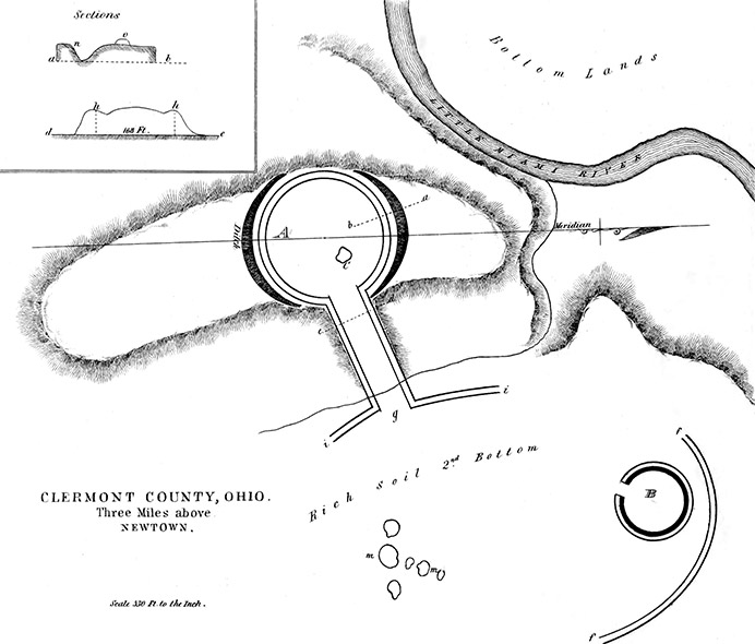
Among the curious structures of the mound-builders, there are none more difficult to explain than this. On a detached ridge, composed of limestone gravel, covered with a clay loam, is a low wall, averaging two feet high, and fifteen feet broad, nearly in the form of a circle; although its north and south diameter is about twenty-five feet the longer. The average diameter of the circle is four hundred and seventy feet. The flat ridge on which the figure A is situated, is about twenty-five feet higher than the adjacent plain; which is from twenty-five to thirty-five feet above the Little Miami River. Outside of the circular figure, there is a space from twenty to thirty feet wide, on the natural surface of the ground. On the two opposite sides of the circle, where it occupies the height of the ridge, is an external ditch, or excavation, enclosing about half the figure. It is from seventy to eighty-five feet broad at the top, and from twelve to eighteen feet deep. The bottom of this trench is not smooth, and is from seven to ten feet higher than the adjacent plain. Its sides are as steep as the gravel and earth will lie. On the east, in the direction c g, is an embankment or grade, extending by a gradual slope, from the enclosure A to the plain. It is one hundred and sixty-eight feet wide at the neck, where it joins A, and has, at the edges, raised side-walls, like those made for pavements in cities, with a drain or gutter inside. The space be- tween the side-ways is rounded like a turnpike, as represented in the section d e. Its length is six hundred feet, and the side-ways are connected with a low and now almost obliterated wall, turning outwards each way at i, i. Some distance to the north-east is another traceable fragment f, f; and this may, with i, i, have been portions of a large ellipse, now destroyed by time and cultivation.
The earth from the outside ditches of A was used to form the embankment, c, g, through which a rivulet has cut its way near the eastern extremity. The small circle at c represents a mound eight feet high, a little out of the center of the work. The group of mounds m, m, m, are from two to fourteen feet in height. B is a circle, with a slight inside ditch, and a broad opening for an entrance.
The section, a, b, gives the position of the ditch, n, the bank, o, and the space of thirty feet between them, called a berm.
There are some examples of graded ways among the ancient works of Ohio, but none resembling this. The grade at Marietta leads from a strong work down to the Muskingum River, and had an evident purpose, that of access to water. It is principally an excavation and not an embankment. There is also a grade, partly in excavation and partly in bank, from a portion of the Newark works in Licking County, leading to a branch of Licking, or Pataskala River.
The great excavated road at Piketown, likewise descended to water. But here, a grade that might with as little labor have been constructed in a direct line to the Miami River, is made in the opposite direction, away from water. I should judge that the rivulet was not a permanent stream, and therefore could not furnish a constant supply of water. Besides, the graded way instead of terminating at this rivulet, crosses it, and probably by an ancient culvert or sluice, allowed the water to pass under the road.
Without taking such measurements as would be sufficient to estimate the con- tents of the ditch in cubic yards, it appeared to be about equal to the embankment in capacity. The section a, b, gives its form, and the position of the low interior wall.
It is not improbable that there may have been outworks connected with this remarkable group that were not seen, or which have been destroyed by the plough.
Copyright © 2015 Calvin & Rosanna Hamilton. All rights reserved.