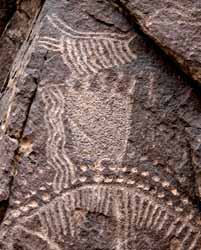
Parowan Gap Petroglyphs
The road to Parowan Gap follows an ancient trail through the red mountains that was used by Native American Indians who lived in Parowan valley. Yearly they would pass through on their way to harvest desert resources. In the process they stopped and pecked designs onto the smooth faces of large boulders found along the gap. Over the years, many of the boulders have been covered with these chiseled figures known as petroglyphs.The precise age of the petroglyphs is unknown, but they are thought to be the work of several cultural groups representing a long period of use by Native American Indians. Archaeological research has shown that the Parowan Freemont, a local variant of the Freemont Indians, lived up and down the Parowan valley. There is little doubt that some of the designs were made by this group or perhaps the earlier nomadic Archaic peoples. Researchers believe that the semi-nomadic ancestors of the present day Southern Paiute also created some of the figures.
 What do these designs mean? Some have suggested that they are
meaningless graffiti, but as one Indian said, "a person doesn't
work for hours and days deeply inscribing figures in solid rock
just to doodle." Others debate that they represent concepts, ideas
or actual happenings. Perhaps they were part of a religious activity
or hunting ritual. The local Native Americans consider them to be
an important part of their cultural history relating stories of their
ancestor's.
What do these designs mean? Some have suggested that they are
meaningless graffiti, but as one Indian said, "a person doesn't
work for hours and days deeply inscribing figures in solid rock
just to doodle." Others debate that they represent concepts, ideas
or actual happenings. Perhaps they were part of a religious activity
or hunting ritual. The local Native Americans consider them to be
an important part of their cultural history relating stories of their
ancestor's.
|
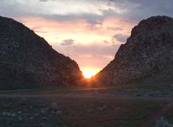
| Sunset looking through the Parowan gap. |
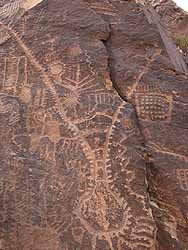
One of the great discoveries within the last few years is that the Indians here must have been fascinated with numbers and dates. To them the Gap became a great calendar of times and seasons. The inscription on the Zipper petroglyph has been determined to be a calendar with solar alignments, a map, and a system of outer cairns (gathering of stones). Nal Morris has presented a fascinating study titled Calendar Glyph and Solar Alignments.
Discovery and Recent History
In 1849 Parley P. Pratt led an expedition from the north into what is now known as Parowan Valley. The expedition was to scout out places for new settlements. They set up camp for winter and while exploring the canyons in the area, discovered the petroglyphs. The discovery was recorded by Robert Campbell in his journal. Chief Walker told these explorers that the place was "God's Own House".Parowan gap was soon used by white settlers as an access route. Just west of the gap narrows and about five miles south was a marshy lake that was important to the Indians and white settlers. This lake became known as Rush Lake. A spring flowed out from the lava mountain providing fresh water for a host of water fowl and other small animals.
For some time the gap narrows was used as a rock quarry and a single lane road was built though it. Eventually, improvements needed to be made and in 1963 many of the large stones were cleared away and even one large boulder covered with petroglyphs and known as the "Hotel" was blasted into pieces. A number of others were also blasted destroying a number of choice drawings. It has been estimated that as little as one half of the cultural record was destroyed since the time of the Parley P. Pratt expedition.
How the Wind Gap was Formed
Approximately 15 million years ago, a long slender section of sedimentary rock sheared from the earth's crust along parallel fault lines. This up-thrown block, later name the Red Hills, began to inch its way above the surrounding valley floor. At the same time the block was rising, a stream was cutting a path perpendicularly across the ridge. For millions of years the uplifting of the ridge and the down-cutting of the stream remained in equilibrium.Eventually, the relentless rise of the ridge and the drying of the region's climate combined forces to defeat the stream. The stream disappeared and the valley became a waterless wind gap. Continued erosion by wind and rain have shaped the gap into the pass seen today.
Copyright © 2003-2006 Calvin & Rosanna Hamilton. All rights reserved.