A Living Landscape
New Mexico is one of the most geologically active areas of the forty-eight contiguous states. On the surface volcanoes are resting while rivers carve the earth, mountain ranges are thrust skyward, and howling winds erode and deposit sand and soil. Yet hidden beneath the surface is the culprit responsible for much of New Mexico's beauty, the Rio Grande Rift. It works slowly spreading the continental crust apart while leaving evidence of its powerful presence behind. Its effects are standing tall on the western edge of Petroglyph National Monument—the Albuquerque volcanoes whose ancient flows gave birth to an extensive mesa and a jagged, boulder-strewn escarpment. Working together—the Rio Grande Rift, volcanoes, rivers, wind—along with time, these earth forming forces continue to mold New Mexico's landscape.
The Rio Grande Rift
The Rio Grande Rift runs vertically down the length of New Mexico. (Figure 1) The rift formed when the crust of the Colorado Plateau to the west pulled away from the crust of the Great Plains to the east. As the divergence continued, a giant crack developed where the Colorado Plateau and Great Plains meet. The crust in between was stretched and thinned like soft baking dough. Large blocks of the crust dropped down into the crack. A trough was created by this cracking and down-dropping. The trough is forty miles wide in the Albuquerque area. On the east side are the Sandia Mountains and on the west side is the Rio Puerco. Petroglyph National Monument is located in the center of the rift. (Figure 2)
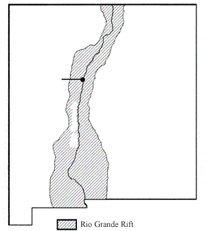 Figure 1 |
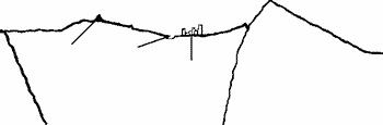 Figure 2 |
Birth of a Grand River
Before the rift formed, streams flowed from west to east, emptying into the Gulf of Mexico. Early streams carried mass amounts of alluvial sediments, sand and gravel, that began filling in the rift as it formed. The sediments filling the rift are known as the Santa Fe Formation. As the rift deepened those streams started following the north-south trough of the rift. Eventually, the streams combined into a single river called the Rio Grande. The Rio Grande flows approximately four miles east of the monument.
Albuquerque's Volcanoes
The area surrounding the rift was unstable and subject to many earthquakes that formed deep cracks, called fissures. Geologists estimate that 130,000 years ago magma rose along a five-mile long fissure and reached the earth's surface. Being a non-violent fissure eruption, lava flowed eastward in a sheet-like fashion and covered the Santa Fe Formation, an accumulation of sand and gravel up to 25,000 feet thick. (Figure 3) The lava cooled and hardened, transforming into basalt rock.As the lava cooled, the fissure was blocked and vents were created. From these vents, cinder and lava accumulated creating the volcanic cones we see today. (Figure 4) Three of the cones are most prominent, standing tall on the western edge of the monument. They are known locally as the Three Sisters.
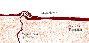
Figure 3 |
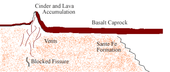
Figure 4 |
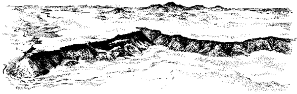
The West Mesa And The Creation Of The Escarpment
Petroglyph National Monument is located in an area commonly known as the West Mesa. The West Mesa is basalt lava rock that rests on the Santa Fe Formation, the accumulation of sand and gravel that eroded from the surrounding mountains and mesas.Due to the erosional powers of wind and water over thousands of years, the soft sediments of the Santa Fe Formation were carried away. Without any support beneath it, the heavy basalt caprock broke and collapsed over the side, creating today's West Mesa escarpment or edge. (Figure 5) The escarpment stretches for 17-miles along Albuquerque's western landscape and is the place where American Indians and Spanish settlers chose to carve petroglyphs.
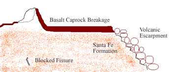
Figure 5
Minerals Matter
In many areas of the monument white deposits can be seen on the rocks and boulders. These mineral deposits are a calcium carbonate substance called caliche. Caliche forms as a result of the interaction of water and decaying organisms. As plants and animals decompose, they release carbon dioxide (CO2). When CO2 mixes with water, a weak acid called carbonic acid (CH2O3) forms. The weak acid is able to leach calcium out of the soil. The calcium reacts with the carbonic acid to form an watery solution of calcium carbonate (CaCO3).The watery solution can move through the soil and deposit itself on just about any hard surface, in this case the basalt rocks and boulders. If there is nothing for the solution to deposit itself on, it can travel down through the soil and create large beds or layers of caliche called calcrete. Caliche beds are typically found three to ten feet below the surface. Wherever the white deposits are seen it is evidence the soil has been disturbed or the rocks have been moved.
The escarpment supports distinctive plant species not found in the canyons or mesa top areas of the monument. Many native plants have adapted to the mineral rich soils and are reliant upon calcium to survive and reproduce. Some plants, such as Mariola (Parthenium incanum), grow only amongst the calcium rich soils of the escarpment.
The Petroglyphs
American Indians and Spanish settlers carved their images on these basalt boulders. The nature of the rock itself is what allows the petroglyphs to be visible. The basalt is high in iron, manganese and calcium. The combination of these minerals makes the basalt a light gray color. After long exposure to oxygen and water the iron and manganese oxidize or rust. A dark shiny coating, or patina, forms on the surface of the basalt boulders. The patina is called desert varnish.When looking at the dark basalt boulders, you are actually looking at desert varnish. American Indians discovered permanent marks could be made by using another rock to chip off the desert varnish. Many American Indians are able to claim cultural relationships to past inhabitants of this area be cause they recognize the images as having deep cultural and spiritual significance. Please respect the importance of petroglyphs to American Indians and to the descendants of original Spanish settlers.
Copyright © 2003-2006 Calvin & Rosanna Hamilton. All rights reserved.