Cedar Breaks
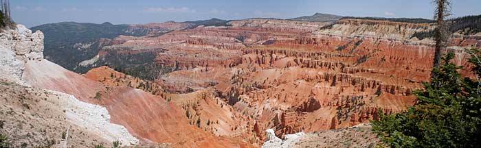
Cedar Breaks National Monument can be found just east of Cedar City, Utah. It is lesser known than its close and similar neighbor, Bryce Canyon which is 40 miles further east. While these two National Park units are very similar both in geological and physiological terms, there are definitely some differences that must be noted. Both are located in the transition zone between the Basin and Range and the Colorado Plateau. Both locations feature remarkable erosion of Tertiary Claron formation which has led to spectacular vistas of pink, orange, and white cliffs and amphitheatres. Cedar Breaks National Monument is shaped like a large coliseum with an amphitheatre that is more than 2,000 feet deep and 3 miles across. Carving this huge bowl took millions of years of erosion and uplift. In contrast to Bryce Canyon, Cedar Breaks is located at a much higher elevation than its neighbor, at nearly 11,000 feet. Because of this, the landforms in this area have also been shaped by glacial and periglacial erosion processes. Many of the formations in Cedar Breaks National Monument show evidence of the transitional zone that is its geologic setting.
Copyright © 2005-2006 Calvin & Rosanna Hamilton. All rights reserved.