Timpanogos Cave National Monument
Geologic History
This section highlights the map units (i.e., rocks and unconsolidated deposits) that occur in Timpanogos Cave National Monument and puts them in a geologic context in terms of the environment in which they were deposited and the timing of geologic events that created the present landscape.
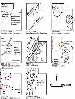 |
| Figure 9. Generalized graphic overview of geologic evolution of Utah from the Archean Eon to the Holocene Epoch (adapted from Hintze 1988). |
The oldest rocks provide a rare glimpse into the tectonic setting of the Proterozoic Eon (figure 10 - below). The earliest event preserved and recorded by rocks exposed in the Timpanogos Cave quadrangle was the deposition of the layers of sand and mud from nearby highlands. These deposits now form the uppermost part of the Big Cottonwood Formation. This deposition was interrupted by a prolonged period of glaciation during which massive tongues of ice extended into the area and deposited great bodies of poorly sorted glacial till (now tillite, the lithified equivalent of a jumbled assortment of rock sizes and types, Mineral Fork Tillite). This ancient glaciation was followed by local tectonic uplift and subsequent extreme erosion. These eroded surfaces were overlain by deposition of red sand, mud, and gravel, which now constitute the Mutual formation. This formation is the youngest unit of the Precambrian system at the monument and underlies American Fork Canyon today (figure 11 - below) (Baker and Crittenden 1961).
Late Proterozoic rifting created a new continental margin along western North America. During the Late Precambrian through the Cambrian, thousands of feet of shallow- water, marine sediments accumulated along a passive plate- tectonic margin on the western side of the Transcontinental Arch, an upland that stretched from northern Minnesota southwestward across Nebraska, Colorado and northwestern New Mexico (Speed 1983; Sloss 1988; Graham et al. 2002). The area that is now Timpanogos Cave was approximately located along the shoreline in this paleoenvironment.
Throughout the Paleozoic Era, Europe, Africa, and South America were approaching North America as the two great landmasses, Laurasia and Gondwana, collided. The ancient continent of Gondwana included Australia, Antarctica, Africa, South America, and India south of the Ganges River, plus smaller islands. Laurasia, located in the northern hemisphere, contained the present northern continents (Graham et al. 2002).
In the early Cambrian Era, the region again underwent an uplift and erosional event. Following the uplift, the region subsided and an ancient sea advanced bringingwith it the depositional environments necessary to capture vast amounts of sediments including the sand for the Tintic Quartzite, the mud for the Ophir Formation, and as the sea deepened, the limy ooze that lithified into the Maxfield Limestone.
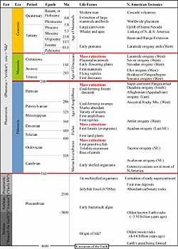 |
| Figure 10. Geologic time scale; adapted from the U.S. Geological Survey. Red lines indicate major unconformities between eras. Included are major events in life history and tectonic events occurring on the North American continent. Absolute ages shown are in millions of years. |
In Utah, Cambrian strata are more widely distributed than deposits of any other time (Hintze 1988). Thinly laminated stromatolitic dolomites and mottled muddy limestones in the Middle and Upper Cambrian of Utah were deposited in very shallow marine waters that deepened westward. A wedge of Cambrian Period sediments thickened from eastern to western Utah approaching a total thickness of 3,700 m (12,000 ft) near the Utah/Nevada state line (Hintze 1988). The lateral and vertical distribution of marine fossils, primarily trilobites, paints a picture of the Utah area in Cambrian times with a shoreline slowly migrating eastward from Nevada to central Utah during the Early and Middle Cambrian. By Late Cambrian time, marine waters covered virtually the entire state. The Equator ran northward through Utah, and limy muds accumulated under these warm- water conditions in much the same way as they do in the broad lime-mud shoal- bank area in the Bahaman Islands today. The Ophir Formation and Maxfield Limestone are present in Timpanogos Cave National Monument as testament to these pervasive seas (Hintze 1988).
Whether similar deposition continued into the Ordovician, Silurian, and Devonian periods is not known because no sedimentary rocks representing any of those periods have been found in this part of the Wasatch Mountains. If any were deposited, they have since been removed, together with much of the Cambrian age rocks in some places, during the long erosion interval that is recorded in the profound unconformity at the base of the Mississippian age rocks (Baker and Crittenden 1961).
From elsewhere in Utah, rocks recording broad carbonate shelves evolving into open and restricted marine environments and later near- shore marine environments, fill in stratigraphic unknowns or gaps left in the Timpanogos area rock record.
In the Middle Devonian Period (about 401 Ma), the first compressive pulses of the Antler Orogeny in the west and the Acadian Orogeny in the east (part of the Appalachian Orogeny) began, as landmasses accreted onto both the western and eastern borders of North America.
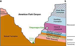 |
| Figure 11. Generalized cross section of American Fork Canyon including Timpanogos Cave system (adapted from NPS graphic). |
During orogenic events, great sheets of rocks measuring tens to hundreds of kilometers in width and length are stacked on top of one another. The weight depresses the land in front of the thrust sheets, or foreland, and causes the foreland to subside into a foreland basin. As the highlands to the west were thrust above sea level at the beginning of the Mississippian, warm shallow marine water flooded the foreland basin and spread over eastern Utah giving rise to an extensive carbonate platform.
Found in the thick Mississippian marine limestones are fossils of animals that lived in normal marine salinity such as brachiopods, trilobites, corals, bryozoans, crinoids, fish, foraminifera, and conodonts (microscopic structures of an extinct animal that are excellent relative- age indicators). The sea became shallower during the regression that followed the Antler Orogeny, however, and habitats dwindled so that marine life became more restricted. Eastern Utah became a broad karst plain of shallow- marine sandstone and micrite (carbonate mudstone), and by the end of the Mississippian, the area was again exposed to subaerial erosion (Poole and Sandberg 1991; Graham et al. 2002).
During Early Mississippian and much of Late Mississippian time, layers of carbonates, intermittently alternating with sandy sediments, accumulated at roughly equal deposition rates north and south of the present day site of the Charleston Fault zone. These were to become the Fitchville, Gardison, Deseret, and Humbug Formations. Very late in the Mississippian period, and throughout Pennsylvanian and Permian time, more than 9,144 m (30,000 ft) of sediments accumulated in the basin to the south and west of the Charleston fault zone, whereas to the north and east less than 1,524 m (5,000 ft) of beds were laid down.
As the sea became shallower during the regression that followed the Antler Orogeny and the Kaskaskia Sequence came to an end, the shoreline again receded from the Transcontinental Arch and by early Pennsylvanian time, soils were beginning to form in low lands and the higher areas were being worn down by erosion. Much of the Oquirrh, Park City Formations, and possibly all of the Great Blue Limestone and Manning Canyon Shale may be missing to the north of the Timpanogos Cave quadrangle due to this erosion.
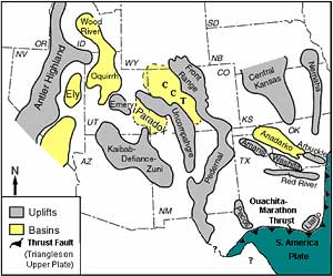 |
| Figure 12. Major uplifts and basins present during the Pennsylvanian age in the southwestern United States. Sediment eroded from the uplifts was deposited in the adjacent basins. Modified from Rigby, (1977). |
As the Ancestral Rocky Mountains formed, the Ouachita-Marathon thrustbelt, the Anadarko Basin, and other Permian basins developed to the southeast and the Oquirrh Basin subsided to the northwest (Jordon and Douglas 1980; Peterson 1980; Kluth 1986; Gregson 1992). Vertical relief in some of these basins relative to sea level (i.e., the Oquirrh and Central basins) was greater than the emergent mountains, and the Ancestral Rockies may have reached as much as 3,000 m (10,000 ft) of relief.
The thick sedimentary sequence of the Oquirrh Group in the Timpanogos Cave area represents the variety of shallow marine and arid near shore environments present in the Oquirrh basin area throughout the Pennsylvanian, including eolian dunes, marine shelf, open coastal area, intermittent fluvial systems/channels, and protected waters (Konopka 1982). The Oquirrh Basin along with all of these paleotectonic structures probably reflect a similar tectonic stress field controlled by Precambrian structural weaknesses and the compressional stress- field that evolved with the assembly of Pangaea (Tweto 1977; Kluth 1986; Ross and Ross 1986; Gregson 1992).
Continuing from the Pennsylvanian, during the middle part of the phase of the Park City Formation deposition, in Permian time, shallow stagnant seas persisted over most of the Timpanogos Cave region. These seas provided the arid/evaporitic conditions required for deposition of phosphate and other salts (Baker and Crittenden 1961). Across the globe, the Permian Period was a time of dramatic environmental change. The Permian equator was oriented southwest- northeast through Wyoming and eastern Utah. An arid climate prevailed in this western part of the supercontinent Pangaea and resulted in restricted marine evaporitic conditions over much of the cratonic shelf seaway (Peterson 1980; Graham et al. 2002). These shallow seas filled basins such as the Oquirrh and Paradox Basins, with incredible accumulations of sediments and salts.
From rock deposits around the globe, geologists have documented the third, and most severe, major mass extinction of geologic time at the close of the Permian. Geologists think a comet, about 6- 13 km (4 to 8 mi) in diameter, collided with the Earth (Becker et. al. 2001). The heat and shock waves generated from such an impact may have triggered vast volcanic eruptions that spread lava over an area two- thirds the size of the United States. Imagine, for example, basalt flows covering the area from San Francisco to St. Louis and Seattle to New Orleans. The amount of ejecta, volcanic ash, and toxic gases from such an event would have been devastating.
References:
Baker, A.A., M.D. Crittenden, Jr. 1961. Geology of the Timpanogos Cave Quadrangle, Utah. U.S. Geological Survey, Report: GQ- 0132.
Becker, L., R.J. Poreda, A.G. Hunt, T.E. Bunch, M. Rampino. 2001. Impact event at the Permian- Triassic boundary, Evidence from extraterrestrial noble gases in fullerenes. Science, February 23: 1530- 1533.
Graham, J. P.,T.L. Thornberry, T.L., S.A. OMeara. 2002. Geologic Resources Inventory for Mesa Verde National Park. Fort Collins, CO: unpublished.
Gregson, J. 1992. Geology and tectonics of the Ancestral Uncompahgre Uplift and the Colorado Orogeny. In Uncompahgria Journal, ed. Gregson, J.D., 19- 46. Grand Junction, CO: Mesa State Geology Department.
Hintze, L.F. 1993. Geologic history of Utah. Brigham Young University Geologic Studies, Special Publications 7.
Jordan, T. E., R.C. Douglass. 1980. Paleogeography and structural development of the late Paleozoic to early Permian Oquirrh Basin, northwestern Utah. In Paleozoic Paleogeography of the West- Central United States, eds. Fouch, T.D., E. R. Magathan, 217- 238. SEPM (Society for Sedimentary Geology).
Kluth, C. F. 1986. Plate tectonics of the ancestral Rocky Mountains. In Paleotectonics and Sedimentation in the Rocky Mountain Region, ed. Peterson, J.A., 353- 369. American Association of Petroleum Geologists Memoir 41.
Konopka, E.H., R.H. Dott, Jr. 1982. Stratigraphy and sedimentology, lower part of the Butterfield Peaks Formation (Middle Pennsylvanian), Oquirrh Group, at Mt. Timpanogos Utah. Utah Geological Association Publication 10: 215- 234.
Peterson, J. A. 1980. Permian paleogeography and sedimentary provinces, west central United States. In Paleozoic Paleogeography of the West- Central United States, eds. Fouch, Thomas D. Esther R. Magathan, 271- 292. Rocky Mountain Section, SEPM (Society for Sedimentary Geology).
Poole, F.G., C.A. Sandberg, C. A. 1991. Mississippian paleogeography and conodont biostratigraphy of the western United States. In Paleozoic Paleogeography of the Western United States - II, eds. Cooper, John D., Calvin H. Stevens, 107- 136. Society of Economic Paleontologists and Mineralogists (SEPM), Pacific Section.
Ross, C.A., J.R.P. Ross. 1986. Paleozoic paleotectonics and sedimentation in Arizona and New Mexico. In Paleotectonics and Sedimentation in the Rocky Mountain Region, ed. Peterson, J.A., 653- 668. American Association of Petroleum Geologists Memoir 41.
Rueger, B. F. 1996. Palynology and its relationship to climatically induced depositional cycles in the Middle Pennsylvanian (Desmoinesian) Paradox Formation of Southeastern Utah. U.S. Geological Survey Bulletin 2000- K, 4 plates.
Sloss, L.L. 1988. Tectonic evolution of the craton in Phanerozoic time. In Sedimentary Cover - North American Craton, ed. Sloss, L.L., 25- 52. Geological Society of America, Geology of North America, Vol. D- 2.
Speed, R.C. 1983. Evolution of the sialic margin in the central western United States. In , in J Studies in continental margin geology, eds. Watkins, S., C.L. Drake, 457- 468. American Association of Petroleum Geologists Memoir 34.
Tweto, O. 1977. Nomenclature of Precambrian rocks in Colorado. U.S. Geological Survey Bulletin 1422- D.
Copyright © 2003-2006 Calvin & Rosanna Hamilton. All rights reserved.