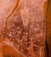
The following is taken from a Bureau of Land Management publication listing some of the Rock art sites in Moab, Utah. This is not a comprehensive list as there are thousands of petroglyphs through out the area.

Take Highway 191 south to the golf course turn off (approximately 4 miles from the corner of Main and Center in downtown Moab). Turn left and proceed to Spanish Trail Road approximately 1 mile just past the fire station located on the left-hand side of the road, turn right onto Westwater Drive. Proceed 0.5 miles to a small pullout on the left-hand side of the road.
The panel runs from ground level up to approximately 30 feet on the high rock wall. Designs cover an area about 90 feet wide. The panel is from the Formative Period and you will be able to see human figures, such as the "Moab Man," elk, canines, and big and small bighorn sheep. Look to the far right of the panel and find what is popularly referred to as the reindeer and sled.
 At the corner of Main and Kane Creek Drive (McDonald's is on the southwest corner) turn west and proceed 0.8 miles to the intersection of Kane Creek Drive and 500 West. Stay left and continue along Kane Creek Drive approximately 2.3 miles to the mouth of Moon Flower Canyon. Along the rock cliff just beyond the canyon, you will see a rock art panel dating from the Archaic to Formative Periods. The site is behind the tall protective fence. There is a Barrier Canyon Style figure (a large triangular shape with head-dress), desert, bighorn sheep and a number of abstract elements. The panel is from ground level to a height of about twelve feet and extending approximately 100 feet. This entire panel is one of the most vandalized rock art sites in the Moab area.
Continue another 1.2 miles to another rock art panel. A huge rock surface covered with desert varnish faces the river from the cliff side of the road. Here, you can see bighorn sheep, snakes, human forms, and a trail, possibly indicating a route from the river up Kane Springs Canyon. Again, you will notice some vandalism. (If you miss this site, it may be seen more easily on the return trip.)
Continue on Kane Creek Drive past the cattle guard where the road turns from pavement to graded gravel road. After traveling 1.7 miles from the previous site, or a total of 5.3 miles from the intersection of Kane Creek Drive and 500 West, you will see two small pullouts suitable for single vehicles. If you are traveling with a large group, continue up the hill where more parking space is available and walk back to the site.
Approximately 75 feet west and down the slope from the road, is a large boulder with rock art on all four sides. Figures and designs range from the Formative to the historic Ute period. The well-known "birthing scene" is found on the left-hand corner of the east side of the boulder (facing the road). Notice the feet-first presentation of the baby. Look for various animal forms, such as a centipede and a horses, bear paws and a snake, as well as triangular anthropomorphic (human) figures and a sandal trackway.
You will see large painted ghost-like illustrations typical of the Barrier Canyon Style Archaic figures on the red-orange surface. The numerous figures include human forms, bighorn sheep, shields, scorpion-like illustrations, possible dogs, a long-beaked bird and abstract elements. You can see evidence of painted multicolored figures superimposed on other pictographs. On the desert varnish surface you will see human and animal-like figures as well as abstract forms. This site is on the National Register of Historic Place because of its representation of a Barrier Canyon Style rock art panel.
The round holes carved into the sandstone underneath the left side of the petroglyph panel once held the roof poles of a structure which was excavated by archaeologists prior to road construction. The structure and the rock art panel were easily accessible before the talus slop was cleared away to make room for the road. Continue south 200 yards to the next "Indian Writing" sign. You will find the large bear with a hunter at the bear's nose and another over its back. At an interpretive pullout approximately 0.75 miles further along the Utah Scenic Byway 279, you can see Indian rock art and dinosaur tacks. On the north side of the road two spotting tubes indicate the location of three-toed allosaurus track in the Navajo / Kayenta sandstone interface. Binoculars are needed to view the petroglyphs located to the left of the tracks at the base of the cliff.
Approximately 7.5 miles farther along Highway 279 is Jug Handle Arch (near the mouth of Long Canyon). Proceed to Jug Handle parking area via a dirt road that travels east from the highway. The rock art is located above the parking area to the north.