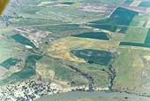
SIA2995: Long Divide

|
|
Related Documents
Download Options
| Image Name | Width x Height | Size |
|---|---|---|
| SIA2995.jpg | 640 x 430 | 60K |
| SIA2995.jpg | 1200 x 807 | 178K |
| SIA2995.jpg | 3150 x 2118 | 951K |
Caption
This photo shows the gravel road at the top going over the mountain and is called the Long Divide. Cutler Reservoir is on the bottom of the photo. The Bidwell trail would have proceeded from the right center to the left center of the photo.
Copyright © 2005-2009 Calvin & Rosanna Hamilton. All rights reserved.