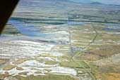
SIA3012: Corinne

|
|
Related Documents
Download Options
| Image Name | Width x Height | Size |
|---|---|---|
| SIA3012.jpg | 640 x 430 | 54K |
| SIA3012.jpg | 1200 x 807 | 161K |
| SIA3012.jpg | 3178 x 2137 | 1M |
Caption
This aerial view is facing west of Corinne showing the wet areas above the lake and the 1869 railroad bed going straight west in the center of the photo. Highway SR 38 is the road curving to the right on the right hand side of the photo. The trail had to follow close to that of SR 38.
Copyright © 2005-2009 Calvin & Rosanna Hamilton. All rights reserved.