

GENESEE COUNTY.
A NUMBER of very interesting remains formerly existed in this county; but few of them are sufficiently well preserved to be satisfactorily traced. In the town of Alabama, in the extreme northwest of the county, were once three of these works, all of small size. The plough has completely defaced them. This town adjoins the town of Shelby, in Orleans county, on the south; and touches Newsted, in Erie county, on the west. It will ultimately be seen that its ancient works constitute part of a chain extending from the "Lake Ridge" on the north to Buffalo Creek on the southwest, a distance of fifty miles. Not less than twenty ancient works are known to occur within this range.
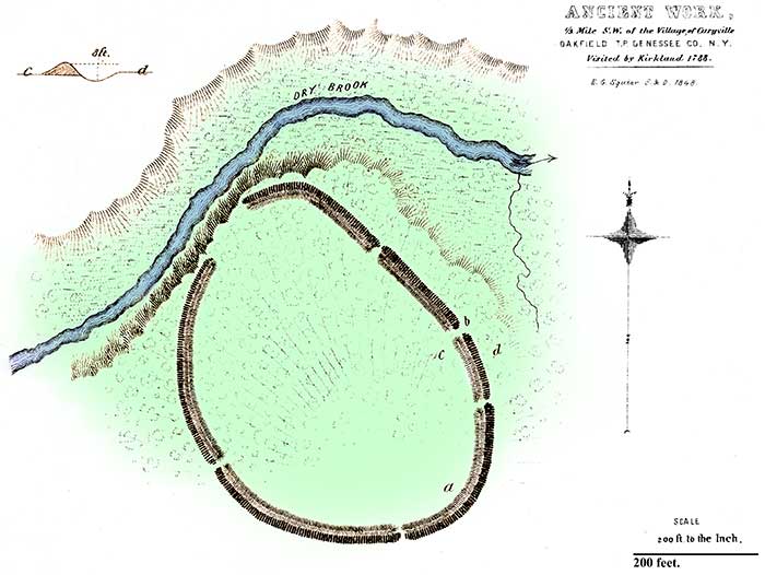
PLATE VIII. No. 2.
ANCIENT WORK, OAKFIELD, GENESEE COUNTY, NEW YORK.
IN the town of Oakfield, half a mile west of the little village of Caryville, is found the ancient enclosure, a plan of which is here given. It is remarkable as being the best preserved and most distinct of any in the State which fell under the notice of the author. It is situated upon the western slope of one of the billowy hills which characterize the rolling lands of the West, and between which the streams find their way to the rivers and lakes. The banks of the little stream which washes the work upon the north are steep, but not more than ten feet in height. Upon the brow of the bank, where the stream approaches nearest the work, the entrenchment is interrupted, and the slope towards the water is more gentle than elsewhere, indicating an artificial grade. The plan obviates the necessity for a detailed description. The embankments will now probably measure. six feet in average height, measuring from the bottom of the trench. In the part of the work under cultivation, it is easy to trace the ancient lodges. Here, too, is to be found the unfailing supply of broken pottery. At the sides of the principal gateway (a), leading into the enclosure from the east, according to the statement of an intelligent aged gentleman, who was among the earliest settlers in this region, traces of oaken palisades were found, upon excavation, some thirty years ago. They were, of course, almost entirely decayed. A part of the area is still covered with the original forest, in which are trees of the largest dimensions. An oaken stump upwards of two feet in diameter stands upon the embankment at the point b. About one mile northeast of this work was originally a large enclosure, but which is now entirely destroyed. It was called the "Bone Fort," from the circumstance that the early settlers found within it a mound, six feet in height by thirty at the base, which was entirely made up of human bones slightly covered with earth. A few fragments of these bones, scattered over the surface, alone mark the site of the aboriginal sepulchre. The popular opinion concerning this accumulation is, that it contained the bones of the slain, thus heaped together after some severe battle. It will, however, be seen that it probably owed its origin to the same practice to which we are to attribute the "bone pits" found elsewhere, that of collecting together at stated intervals the bones of the dead—a practice very prevalent among the northwestern Indians.
There is no doubt but this is one of the works visited by Rev. Samuel Kirkland, Missionary to the Senecas, in 1788. His MS. Journal was in the possession of Messrs. Yates and Moulton, who have given a synopsis of the part relating to this group of remains in the subjoined passages.
"Having examined the works (already referred to, in Monroe county) on the Genesee, he returned to Kanawageas, and resumed his journey west, encamping for the night at a place called Joaika, i.e. Raccoon (Batavia), on the river Tonawande, about twenty-six miles from Kanawageas. Six miles from this place of encampment, he rode to the open fields, and arrived at a place called by the Senecas Tegataineáaghgue, Which imports a 'double-fortifed town,' or a town with a fort at each end. Here he walked about half a mile with one of the Seneca chiefs, to view the vestiges of this double-fortified town. They consisted of the remains of two forts: the first contained four acres of ground; the other, distant about two miles, at the other extremity of the ancient town, enclosed about eight acres. The ditch around the first was about five or six feet deep. A small stream of water and a high bank circumscribed nearly one third of the enclosed ground. There were traces of six gates or openings, and near the centre a way was dug to the water. The ground on the opposite side of the water was in some places nearly as high as that on which the fort was built, which might render this covered way to the water necessary. A considerable number of large thrifty oaks had grown up within the enclosed ground, both in the ditch and upon the wall; some of which appeared to be two hundred years old or more. The ground is of a hard, gravelly kind, intermixed with loam, and more plentifully at the brow of the hill. At some places at the bottom of the ditch, Mr. Kirkland ran his cane a foot or more in the soil ; from which circumstance he concludes that the ditch was much deeper originally.
"Near the western fortification, which was situated on high ground, he found the remains of a funeral pile, where the slain were buried after a great battle, which will be spoken of hereafter. The mound was about six feet in height by thirty feet diameter at the base. The bones appeared at the surface, projecting at many places at the sides.
"Pursuing his course towards Buffalo Creek, (his ultimate destination,) Mr. Kirkland discovered the vestiges of another fortified town. He does not delineate it in his MSS., but says: 'On these heights, near the ancient fortified town, the roads part; we left the path leading to Niagara on our right, and went a course nearly southwest for Buffalo Creek. After leaving these heights, which afforded an extensive prospect, we travelled over a fine tract of land for about six or seven miles, then came to a barren white-oak shrub plain. We passed a steep hill on our right, in some places fifty feet perpendicular, at the bottom of which is a small lake, affording another instance of pagan superstition. The-old Indians affirm that formerly a demon, in the form of a dragon, resided in this lake, which frequently disgorged balls of liquid fire. To appease him, many sacrifices of tobacco had been made by the Indians. At the extremity of the barren plain, we came again to Tonawande River, and forded it about two miles above the Indian town of that name. At a short distance on the south side of the same stream, is another fortification.'"
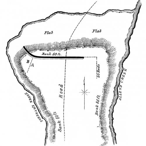
FIG. II.
ANCIENT WORK, LE ROY, GENESEE COUNTY, NEW YORK.
REMNANTS of another ancient work occur in the town of Le Roy, three miles north of the village of the same name, in the southeastern part of this county. The accompanying sketch, by L. H. Morgan, Esq., of Rochester, although not from an exact instrumental survey, is sufficiently accurate for all essential purposes.
The position which the work occupies is a portion of a high plain or tableland, nearly surrounded by deep ravines, bounded by Fordham's Brook and Allen's Creek, which effect a juncture at this point. These streams have worn their beds through the various strata of lime and sandstone to the depth of from seventy to one hundred feet, leaving abrupt banks difficult of ascent. These natural features are best illustrated by the plan, which precludes the necessity for a minute description.
The peninsula measures about 1300 feet from north to south, by 2000 feet at its broadest part, and 1000 feet across the neck connecting it with the general table. Positions similar to this were often selected by the aborigines for defensive purposes, but in such cases have usually an embankment and trench extending across the isthmus. In this instance, however, the only trace of art is an embankment and ditch, about 1500 feet in length, and running nearly east and west across the broadest part of the peninsula, and not very far back from the edge of the ravine. The part which is laid down in the plan is said to be still very distinct; the embankment being between three and four feet in height, and the ditch of corresponding depth. The western extremity of the line curves gently outwards, and extends some distance down the bank, which is at this point less abrupt than elsewhere. It is said that formerly trenches existed on the courses indicated by dotted lines on the plan; but the statement is not confirmed by any remaining traces.
 |
| FIG 3. |
According to Mr. Dewey, "the trench was estimated by the early observers at from eight to ten feet deep and as many wide. The earth in making it had been thrown either way, but much of it inwards. The road formerly crossed it by a bridge. When first known, forest-trees were standing both in the trench and on its sides. In size and growth they corresponded with the forests around them. Prostrate upon the ground were numerous trunks of the heart-wood of black cherry trees of larger size, which, it is conjectured, were the remains of more antique forests, preceding the growth of beech and maple. They were in such a state of soundness as to be employed for timber by the early settlers,"10
From all that remains of this work, it is impossible to conjecture for what purposes it was constructed. Indeed, it bears so few evidences of design, that we are led to distrust its artificial origin; a distrust which is strengthened by the circumstance, that in a number of instances, elevations and depressions bearing some degree of regularity, but resulting from fissures in a rock substratum or other natural causes, have been very generally mistaken for works of art. The fact that the trench in this instance has a course so nearly parallel with the edge of the ravine, is also a suspicious circumstance. The spot was not visited by the author; but he is authorized in saying that Prof Dewey, who gave the first and most complete account of the supposed work, is now inclined to the opinion that it may be the result of natural causes.
On what is called the "Knowlton Farm," about one mile south of the town of Batavia, is a small natural elevation which was used as a burial-place by the Indians. It has been mistaken for a mound. Various relics have been discovered in ploughing over it.
10. Schoolcraft's Notes on the Iroquois, p. 203.
Copyright © 2009 Calvin & Rosanna Hamilton. All rights reserved.