ERIE COUNTY.
ERIE county ranks next to Jefferson in the number of its ascertained aboriginal monuments. The topographical features of the two counties are much the same, although the former is by far the least elevated. Along the shores of Lake Erie and bordering Buffalo Creek are low and fertile alluvials; back of these we come to the limestone formation, and the country rises, forming a second grand terrace, along the brow of which most of the ancient works are situated. Within the limits of the late Seneca Reservation, which has been only in part brought under cultivation, there are a number of ancient works, which are unimpaired except by the operation of natural causes. It is extremely difficult, however, to find them, in consequence of the forest and the thick undergrowth. As the Reservation is cleared up, no doubt new ones will be discovered; and it is to be hoped sufficient interest in these matters may be found to exist among the citizens of Buffalo, to secure their prompt and careful investigation.
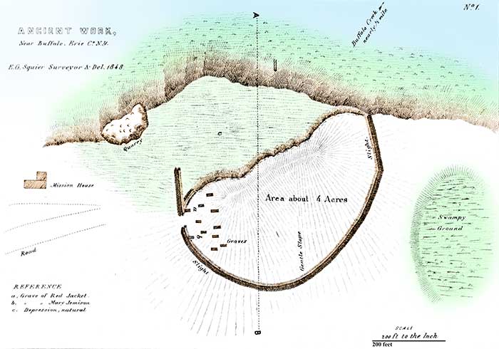
PLATE IX. No. 1.
ANCIENT WORK NEAR BUFFALO.
One of the most interesting works in this county is that here represented. It derives much of its interest from the associations connected with it. The site which it occupies was a favorite spot with the Senecas, and one of their largest cemeteries occurs within its walls. Here is buried an Indian chief whose name is inseparably interwoven with the history of the Five Nations. He was a man who possessed a rare combination of talents, which, developed under different circumstances, would have secured for him a high position among the greatest statesmen and proudest orators of the world. This is hardly a proper place to speak of his character; but his devoted patriotism, hi inflexible integrity, the unwavering firmness, calm and lofty dignity, and powerful eloquence with which he opposed the encroachments of the whites, notwithstanding that he knew all resistance was vain and hopeless—command an involuntary tribute to the memory of the last and noblest of the proud and politic Iroquois, the haughty and unbending Red Jacket, who died exulting that the Great Spirit had made him an Indian! Here, too, is buried Mary Jemison, "the white woman," who, taken a prisoner by the Indians when a child, conformed to their habits, became the wife of one of their chiefs, and remained with them until her death. The story of her life is one of the most eventful of those connected with our border history, filled as it is with thrilling adventures and startling incidents.
The work under notice is situated upon the edge of the second terrace, which is here moderately elevated above the fertile alluvials bordering Buffalo Creek. The particular spot which it occupies is considerably higher than any other near it, and the soil is sandy and dry. It will be seen that the terrace bank upon one side is made to subserve the purposes for which the trench and embankment were erected upon the others. There is now no direct evidence to that effect; but no doubt can be entertained that, in common with all the other works of the State, the wall was crowned with palisades, which were also carried along the brow of the terrace. The greater portion of this work has been for some time under cultivation; and the original lines are so much defaced, that they would probably escape the notice of the careless observer. They may, nevertheless, be distinctly traced throughout their extent. At the point nearest the Indian cemetery, a portion of which is still spared by the plough, the embankment is very distinct, and cannot fail to attract attention. At a short distance to the northward of the work is a low spot of ground or marsh, towards which opens a gateway. From this was probably obtained a portion of the supply of water required by the ancient occupants of the work. A number of springs start from the foot of the terrace where the ground is also marshy. Within the walls of this work are to be found the various traces of occupancy which I have already mentioned, sites of old lodges, fragments of pottery, etc.
Tradition fixes upon this spot as the scene of the final and most bloody conflict between the Iroquois and the "Gah-kwas" or Eries,—a tradition which has been supposed to derive some sanction from the number of fragments of decayed human bones which are scattered over the area.
The old mission-house and church stand in close proximity to this work. The position of the former is indicated in the plan. Red Jacket's house stood above a third of a mile to the southward upon the same elevation; and the abandoned council-house is still standing, perhaps a mile distant, in the direction of Buffalo. A little distance beyond, in the same direction and near the public road, is a small mound, called "Dah-do-sot," artificial hill, by the Indians, who it is said were accustomed to regard it with much veneration, supposing that it covered the victims slain in some bloody conflict in the olden time. A genuine representative of the Celtic stock had selected it as the site of his cabin, and his worthy but some-what superstitious spouse was much horrified at the intimation that it probably contained the bones of the unsanctified heathen. A shaft was sunk near the foundation of the cabin to the base of the mound, but nothing of interest was disclosed. A few half-formed arrow-heads, some chippings of hewn stone, and some small bits of charcoal were discovered, intermingled with the soil thrown from the excavation Whatever deposits are contained in the mound, if any, probably occur immediately beneath the apex which is occupied by the cabin of the Celt aforesaid. Its investigation is therefore reserved for the hands of some future explorer. It was originally between five and six feet in height by thirty-five or forty feet base, and is composed of the adjacent loam. A depression still exists upon one side, marking the spot whence the material was obtained.
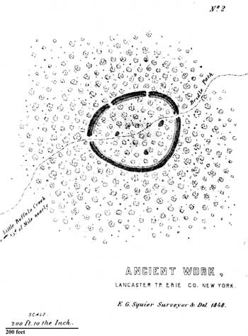
PLATE IX. No. 2.
ANCIENT WORK, LANCASTER, ERIE COUNTY, NEW YORK.
IT is not known that any ancient remains occur nearer the work last described than the one here presented, which is situated upon lot No. 2, of the late Reservation, about four miles southeast of the village of Lancaster, near Little Buffalo Creek. It occurs upon the summit of a small eminence, in the midst of a dense and tangled forest, and is reached by a bridle path which passes through it. It approaches more nearly to the form of a true circle than any work which fell under the observation of the author in Western New York. It is small, containing less than an acre. The embankment is however very distinct, being not less than three feet in height, and the ditch of equal depth. Trees, corresponding in all respects with those of the surrounding forest, are standing within the area and upon the wall. The ground is here gravelly and dry. A number of caches of considerable size were observed within the enclosure.
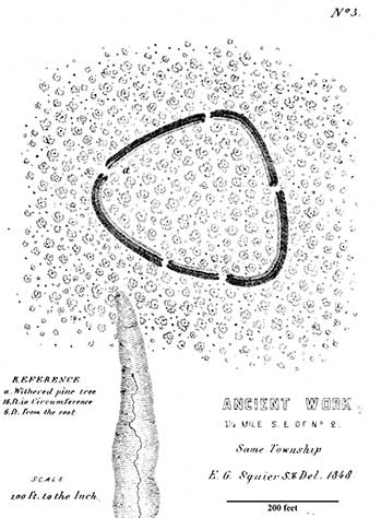
PLATE IX. No. 3.
ANCIENT WORK, LANCASTER, ERIE COUNTY, NEW YORK.
HALF a mile to the southeast of the above work, and as nearly as could be ascertained on lot No. 6, is a work of larger size and more irregular outline. It occupies a beautiful level spot of ground not far from the edge of the second terrace back from the creek. The embankment is somewhat higher than that of the previous work, and, with a single exception, quite as well defined as any observed within the State. It is very slightly reduced from its original height, which may be estimated as having been between seven and nine feet, measuring from the bottom of the ditch. At the point indicated by the letter a upon the embankment is standing the stump of a withered pine-tree, which is sixteen feet in circumference six feet above the roots. A few rods to the southward of the work is a narrow ravine leading off towards Little Buffalo Creek. Within this is a spring from which flows a small stream. It will be observed that two of the gateways of the work placed not far apart open in this direction—leading to the inference that it was here that the water used by the ancient occupants was obtained. A number of large caches also occur within this work.
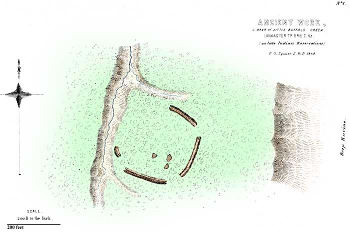
PLATE X. No. 1.
ANCIENT WORK ON LATE INDIAN RESERVATION, ERIE COUNTY, NEW YORK.
UPON the opposite bank of the creek already named, and probably on lot No. 3 of the Reservation, is the singular work here presented. The land upon this side of the creek rises abruptly to the height of 150 or 200 feet, forming a high bluff. The edge of this bluff is cut by ravines into spurs or head-lands; and upon one of these the work under notice is situated. It is not large, and is singular only in having wide interruptions in the embankment—so wide indeed, that were it not from the perfect condition of the lines where they exist, it might be conjectured that the structure was never completed. Caches were noticed here. The ground is covered with a dense forest, which obscures all parts of the work.
To the southwestward of this, on lot 29 of the same range and on the south side of "Big Buffalo Creek," is still another similar work, which is described by Mr. Junius Clark, in a private communication, as about eight hundred feet in circumference, having three gateways and an open space ten rods wide at the southwestern corner. A gateway on the north opens towards a spring of water, distant about a dozen rods. Other works, probably differing in no essential respect from these, are said to occur at various places upon the southern border of the Reservation.
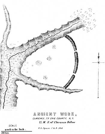
PLATE X. No. 2.
ANCIENT WORK, CLARENCE TOWNSHIP, ERIE COUNTY, NEW YORK.
PASSING northward from the localities last mentioned to the distance of five or six miles, keeping upon the limestone plateau, we find another series of remains, composed of a succession of works placed a mile or two apart, and extending quite through the town of Clarence. The first of these (No. 2) is two and a half miles south of the little village of "Clarence Hollow." It has been under cultivation for a number of years, and its outlines can now be traced only by carefully observing the stronger vegetable growth upon the course of the ancient trench. Where fence lines crossed the wall, short sections of the embankment are yet visible. Fragments of pottery are scattered over the area. If any of the usual pits ever existed, they have been filled up by the operations of agriculture.
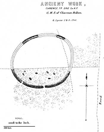
PLATE X. No. 3.
ANCIENT WORK, CLARENCE TOWNSHIP, ERIE COUNTY, NEW YORK.
A MILE northward of the work last described, and occupying a position in no respect well adapted for defence, is the enclosure here presented. It is now much defaced; the part, however, which has never been cultivated is very distinct, and one or two other short sections may yet with some difficulty be traced. Flint chippings, fragments of pottery, and a number of deep caches occur within the area. A large Indian cemetery is said to exist somewhere between this work and the one just noticed. However true this may be, about half a mile to the northwest on the land of a Mr. Fillmore there is a large deposit of bones, a "bone pit," some fourteen feet square and four or five in depth, filled wit h crumbling human skeletons. The spot was marked by a very slight elevation of the earth a foot or too in height.
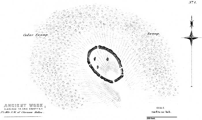
PLATE XI. No. 1.
ANCIENT WORK, CLARENCE TOWNSHIP, ERIE COUNTY, NEW YORK.
A couple of miles distant, still following the brow of the terrace, and not far back of the village of Clarence, was formerly another similar work now completely destroyed. Still a mile beyond is another, (Plate XI. No. 1.,) which, although upon grounds which have been cleared, is yet perfect. It is situated upon a sandy, slightly elevated peninsula, which projects into a low tangled swamp. A narrow strip of dry ground connects it with the higher lands, which border the swamp on the south. It is small, containing less than an acre. The embankment does not preserve uniform dimensions, but has perhaps an average height of three feet. The ditch too is irregular, both in width and depth, owing probably in some degree to the rocky substratum, which in some places comes nearly or quite to the surface of the ground. The stumps of immense pine-trees are standing within the work, as also upon its walls. Here, too, are to be found caches, fragments of pottery, etc. The position, for purposes of concealment and defence, is admirably chosen, and recalls to mind the famous stronghold of the Narragansetts in Rhode Island, destroyed in 1676 by the New England colonists under Winthrop and Church.
A short distance from this work, upon the brow of a neighboring elevation, a number of human skeletons have been exposed by the plough. They probably mark the site of an Indian cemetery. A mile to the eastward, upon a dry sandy spot, is another of the "bone-pits" already several times referred to, which is estimated, by those who excavated it originally, to have contained four hundred skeletons heaped promiscuously together. They were of individuals of every age and sex. In the same field are found a great variety of Indian relics, also brass cap and belt plates, and other remains of European origin. Not far distant, some lime burners discovered, a year or two since, a skeleton surrounded by a quantity of rude ornaments. It had been placed in a cleft of the rock, the mouth of which was covered by a large flint stone.
Passing onward in the same direction which we have been pursuing, we come to the Batavia and Buffalo road, the great thoroughfare over which, previous to the construction of the railroad and canal, passed the entire western trade and travel. Here, at a point a few miles from Clarence, known as the "Vandewater Farm," are the traces of another work. A few sections alone remain, barely sufficient to indicate that it was of considerable size. The road passes through its centre.
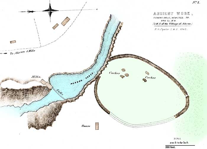
PLATE XI. No. 2.
ANCIENT WORK, FISHER'S FALLS, NEWSTED TOWNSHIP, ERIE COUNTY, NEW YORK.
THE sole remaining work in this county which was personally examined by the author is the one here presented. It is situated five miles eastward of the locality last noticed, at a place known as "Fisher's Falls," in the town of Newsted, upon the banks of a creek, at present barbarously designated "Murder Creek." The creek here plunges down into a deep, narrow gorge with precipitate banks, which continues to the edge of the terrace a fourth of a mile distant. The relative position of the work, which is of large size, is correctly designated on the plan. It is now under cultivation, and is much reduced from its original elevation, but can be traced without difficulty throughout its extent. The older inhabitants affirm that the walls were originally five feet in height, and the ditch of corresponding proportions. Traces of the ancient caches are yet to be observed; and without the enclosure is a rock, the surface of which bears a number of artificial depressions hollowed out by the Indians,—the rude mortars in which they pounded their corn.
This work occurs upon the old Indian trail, which extended from the Genesee River to Batavia, and thence to Buffalo and Niagara. A branch of this trail, after striking the limestone ledge at Tonawanda Creek, followed along its brow to Buffalo Creek. It diverged inwardly at the point under notice, so as to escape the impassable ravine already mentioned. Kirkland, missionary to the Senecas in 1787, passed along this trail on his way to Buffalo, and incidentally refers to a work which he encountered after crossing Tonawanda Creek, and which is probably the one here figured.
Besides the ancient remains here noticed, there are no doubt many others of which no information has yet been obtained. It is not probable, however, that they possess any novel features, or differ materially in any respect from those already described. Some "bone-pits" in addition to those already mentioned occur in Clarence township, and will be noticed in another connection.
This county abounds in traces of recent Indian occupancy; in fact the rude cabins of the aborigines have scarcely crumbled away, since they deserted their favorite haunts upon the banks of the Buffalo Creek and its tributaries. A small band are at bay upon the borders of the Tonawanda, sullenly defying the grasping cupidity of those who Shylock-like, sustained by fraudulent contracts, are impatient to anticipate the certain doom which impends over this scanty remnant, and would deny these the poor boon of laying their bones beside those of their fathers.

