

PLATE I.
ANCIENT EXCAVATION, BIG BOTTOM, PIKE COUNTY.
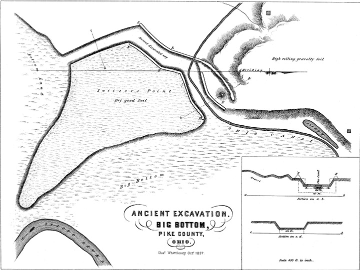
The works here represented are situated on the west bank of the Scioto River near the line between Pike and Ross Counties. The design appears to have been to form a cut or passage from the bottom land above "Switzer's Point," to the bottom land below; but what necessity there was for so expensive a road, is beyond conjecture. The Point (as it is called) is only eighteen or twenty feet above the bottom, and is easy of ascent and descent. Only a very small portion of the earth removed is now to be seen; having been transported to some spot which I did not discover. The banks E, E, E, along a part of the edge of the cut, are light; only one and a half feet high and ten broad.
The sections or profiles a h, and c d, give the dimensions of this ditch, along which the engineers of the Ohio Canal located a portion of their work. If there were any signs of this passage having been acted upon by running water, we might conclude that it had been used for hydraulic purposes; but its sides and bed are very little injured, or worn away; no more so than we might expect from the effect of rains, frost, &c. There are probably other remains in the vicinity, although I could hear of none. At the north-eastern end of the east bank, E, is an artificial mound five feet high and thirty broad; and near the termination of the western embankment is a natural one, disconnected with the bank. A little to the west and north-west, is a natural ridge which appears to have been trimmed by art, and to have been used in connection with the lower portion of the western line of embankment. The second bluff is elevated from forty to sixty feet above the river, and is generally under cultivation, as well as the rich bottoms, which are very extensive.
This work has not the appearance of a drain for swampy land or ponds; for it is not on the most direct course to the river. If designed as a work of defense, it has rendered the Point by no means inaccessible; for the bottom land on the other side is comparatively solid ground, and the low bluff presents no natural obstacle. The trench itself, unless filled with water, would be but a slight impediment. It is situated within twelve miles of the "Graded Way," near Piketon, described in the Smithsonian Contributions, I. p. 88. The mass of earth removed is here greater than at Piketon; where a large portion, though not all, is used in forming the bank at the sides.
I think it probable that this class of works was connected with religious or superstitious ceremonies.
Copyright © 2015 Calvin & Rosanna Hamilton. All rights reserved.