Relative Time Scale
At the close of the 18th century, the haze of fantasy and mysticism that tended to obscure the true nature of the Earth was being swept away. Careful studies by scientists showed that rocks had diverse origins. Some rock layers, containing clearly identifiable fossil remains of fish and other forms of aquatic animal and plant life, originally formed in the ocean. Other layers, consisting of sand grains winnowed clean by the pounding surf, obviously formed as beach deposits that marked the shorelines of ancient seas. Certain layers are in the form of sand bars and gravel banks -- rock debris spread over the land by streams. Some rocks were once lava flows or beds of cinders and ash thrown out of ancient volcanoes; others are portions of large masses of once molten rock that cooled very slowly far beneath the Earth's surface. Other rocks were so transformed by heat and pressure during the heaving and buckling of the Earth's crust in periods of mountain building that their original features were obliterated.
|
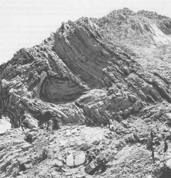
| In places where layers of rocks are contorted, the relative ages of the layers may be difficult to determine. View near Copiapo, Chile. |
Between the years of 1785 and 1800, James Hutton and William Smith advanced the concept of geologic time and strengthened the belief in an ancient world. Hutton, a Scottish geologist, first proposed formally the fundamental principle used to classify rocks according to their relative ages. He concluded, after studying rocks at many outcrops, that each layer represented a specific interval of geologic time. Further, he proposed that wherever uncontorted layers were exposed, the bottom layer was deposited first and was, therefore, the oldest layer exposed; each succeeding layer, up to the topmost one, was progressively younger.
Today, such a proposal appears to be quite elementary but, nearly 200 years ago, it amounted to a major breakthrough in scientific reasoning by establishing a rational basis for relative time measurements. However, unlike tree-ring dating -- in which each ring is a measure of 1 year's growth -- no precise rate of deposition can be determined for most of the rock layers. Therefore, the actual length of geologic time represented by any given layer is usually unknown or, at best, a matter of opinion.
|
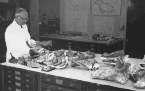
| A paleontologist of the U.S. Geological Survey examining the fossil bones of Paleoparadoxia, an aquatic mammal that lived about 14 million years ago. |
William "Strata" Smith, a civil engineer and surveyor, was well acquainted with areas in southern England where "limestone and shales are layered like slices of bread and butter." His hobby of collecting and cataloging fossil shells from these rocks led to the discovery that certain layers contained fossils unlike those in other layers. Using these key or index fossils as markers, Smith could identify a particular layer of rock wherever it was exposed. Because fossils actually record the slow but progressive development of life, scientists use them to identify rocks of the same age throughout the world.
From the results of studies on the origins of the various kinds of rocks (petrology), coupled with studies of rock layering (stratigraphy) and the evolution of life (paleontology), geologists reconstruct the sequence of events that has shaped the Earth's surface. Their studies show, for example, that during a particular episode the land surface was raised in one part of the world to form high plateaus and mountain ranges. After the uplift of the land, the forces of erosion attacked the highlands and the eroded rock debris was transported and redeposited in the lowlands. During the same interval of time in another part of the world, the land surface subsided and was covered by the seas. With the sinking of the land surface, sediments were deposited on the ocean floor. The evidence for the pre-existence of ancient mountain ranges lies in the nature of the eroded rock debris, and the evidence of the seas' former presence is, in part, the fossil forms of marine life that accumulated with the bottom sediments.
|
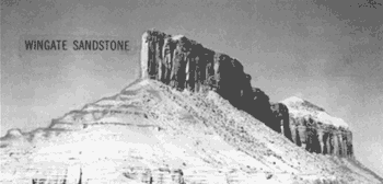
| The Wingate Sandstone is a reddish-brown formation consisting largely of wind-blown sand believed to have accumulated as desert dunes in the Four Corners region of the Southwestern United States about 200 million years ago. Erosion of this formation commonly produces vertical cliffs. View near Gateway, Colorado. |
Such recurring events as mountain building and sea encroachment, of which the rocks themselves are records, comprise units of geologic time even though the actual dates of the events are unknown. By comparison, the history of mankind is similarly organized into relative units of time. We speak of human events as occurring either B.C. or A.D. -- broad divisions of time. Shorter spans are measured by the dynasties of ancient Egypt or by the reigns of kings and queens in Europe. Geologists have done the same thing to geologic time by dividing the Earth's history into Eras -- broad spans based on the general character of life that existed during these times -- and Periods -- shorter spans based partly on evidence of major disturbances of the Earth's crust.
The names used to designate the divisions of geologic time are a fascinating mixture of words that mark highlights in the historical development of geologic science over the past 200 years. Nearly every name signifies the acceptance of a new scientific concept--a new rung in the ladder of geologic knowledge.
The following examples show how the rock layers themselves are used as a relative time scale:
- A diagram correlates or matches rock units from
three localities within a small area by means of geologic sections compiled from
results of field studies.
- Another diagram (212K) is a composite geologic section, greatly simplified.
(This document was adapted from the USGS publication GEOLOGIC TIME by William L. Newman)
Copyright © 2003-2008 Calvin & Rosanna Hamilton. All rights reserved.