| Pu'uloa Petroglyphs | All Pictures | All Pu`uloa Pictures |
|
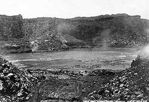
| Historical photo of Halemaumau crater, 1885. |
The First Written Account of Kilauea
The English missionary, Rev. William Ellis, visited the summit region of Kilauea and made the first written description of eruptive activity at the volcano. His foot party departed Kailua on July 18, 1823, eventually reaching Kapapala on July 30. The next day the hikers passed Ponahohoa (also spelled Ponohohoa and Ponahoahoa), where they marveled at still-hot fissures, "chasms," freshly solidified lava, and sulfurous fume ("smoke") related to a large eruption more than a month earlier. The site of Ponahohoa is lost today; the location shown on modern maps is a relatively featureless area inconsistent with Ellis' description. The fissures described by Ellis are probably somewhere along the upper reaches of the Great Crack, now recognized as the source of the 1823 flow.
The explorers spent the night in the lava tube of Keapuana and observed the glow at Kilauea's summit. The next morning (August 1) they walked across a "waste of dry sand" that we now know is a deposit of the explosive eruption of 1790. Passing west of the Kamakaia Hills, Ellis noted more "chasms" and speculated (correctly, we think) that they "are connected with Ponahohoa, and may mark the course of a vast subterraneous channel leading from the volcano to the shore." This structure is what we now call Kilauea's southwest rift zone.
The trade winds blew fume across the hikers as they labored toward the caldera. At about 2 p.m. they found themselves atop a steep precipice 60-120 m (200-400 ft) above a vast plain whose surface was dotted with large stones (from the 1790 explosion) and was indented by a great crater about 2.5 km (1.5 mi) away. By walking northward, the group was able to descend the precipice to the plain and approach the crater. Ellis' description of this route is inconsistent with today's topography and indicates that the terrain was modified by filling of the caldera later in the 19th century.
From the rim of the great crater, Ellis noted an "immense gulf, in the form of a crescent, about two miles [3 km] in length, from north-east to south-west, nearly a mile [1.5 km] in width, and apparently 800 feet [240 m] deep." The "gulf" contained several active lava lakes and 51 conical islands. Some 120 m (400 ft) below the rim was a "black ledge," which Ellis correctly interpreted as a bathtub ring left after withdrawal of lava in the crater. Ellis reasonably surmised that "this evacuation had caused the inundation of the Kapapala coast" (the eruption from Ponahohoa).
The party camped that night on the northeast rim of the caldera near Sulphur Banks. Several men had narrow escapes after falling into cracks covered by sandy ejecta from the 1790 explosions (the "decomposing lava" of Ellis). This area is still hazardous, though less so than in 1823 because much of the sand has washed into the cracks. Pools of fresh water near Sulphur Banks, used by Ellis to fill canteens, may have occupied small hollows lined by silt and clay from the explosions. The pools no longer exist.
The next morning (August 2) most of the group traveled to the south coast via the east side of the caldera. Along the way Ellis climbed down to the black ledge, described lava tubes and cones, and made a famous sketch of the south end of the crater. Still farther Ellis passed Kilauea Iki and noted a fresh lava flow on its floor. At 11 a.m. the party left the summit area and headed southeast, ending at Kealakomo on the coast that night. The pace of the hikers was remarkable!
Ellis' clear narrative is the starting point for all subsequent descriptions of Kilauea's summit area. His estimates of the depth of the caldera, though greater than most later ones, are reasonable, since more detailed observations indicate that the caldera was progressively filling during the rest of the century.
Copyright © 2005-2008 Calvin & Rosanna Hamilton. All rights reserved.