Cedar Breaks - Geology
A Changing Landscape
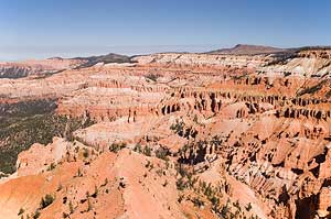
Standing at the rim of Cedar Breaks National Monument, you gaze into a desert of colorful cliffs and pinnacles. If you had visited this area sixty million years ago, however, you would have found yourself treading water in a body of water the size of Lake Erie, surrounded by hills and mountains. The geology exposed at Cedar Breaks reveals the powerful forces of change that have given rise to today's remarkable landscape.
The End of the Ancient Seas
During the Cretaceous period, 144-65 million years ago, the North American continent was slowly drifting towards the southwest, driven by the spreading of the ocean floor. A shallow arm of the sea stretched across most of what is now Texas, Oklahoma, Kansas, Nebraska, North and South Dakota, Colorado, Utah, Arizona and New Mexico.
About 105 million years ago, the plates of earth's crust changed direction and speed. As the heavy Pacific plate plunged under the lighter continental plate at a more rapid rate, it compressed the western margin of the continent. Massive sections of the earth's crust slowly moved eastward along low-angle "thrust faults." This period of faulting, known as the Sevier Orogeny, formed a chain of mountains to the west of what is now Cedar Breaks.
About 80 million years ago, as the Sevier mountains began to erode, a second mountain-building event began to the east. The Laramide Orogeny lasted 40 million years, causing the Cretaceous seabed to lift and drain, and leaving the Rocky Mountains and such features as the San Raphael Swell, the Waterpocket Fold of Capitol Reef, and the Monument Upwarp in its wake. The only traces of the Cretaceous seaway that remain in the area today are the marine sandstones and shales of the Straight Cliffs Formation found in the canyon below Cedar Breaks.
A Great Lake
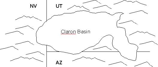
The result of these uplifts to the east and west was the creation of a large lake basin, 70 miles wide and 250 miles long-about the size of present-day Lake Erie. Starting about 60 million years ago, streams flowing from the surrounding highlands washed sand, silt and mud into the basin. Algae living in the lake incorporated calcium carbonate (CaCO2) into their body structures. When they died, their remains left thick deposits of carbonate mud on the lake bottom. Freshwater snails fed in the muddy ooze.
 Periodically, the lake would dry up, leaving a
level plain where soils formed, plants grew, and insects such as ants and wasps burrowed into the dry sediments. Streams ran across the basin, leaving lens-shaped sand and gravel deposits. Then the lake would fill with water and deposition would begin again, adding more layers of sediments.
Periodically, the lake would dry up, leaving a
level plain where soils formed, plants grew, and insects such as ants and wasps burrowed into the dry sediments. Streams ran across the basin, leaving lens-shaped sand and gravel deposits. Then the lake would fill with water and deposition would begin again, adding more layers of sediments.
Deposition continued for 20 to 25 million years, gradually filling up the basin as the surrounding highlands wore down. Trace amounts of iron derived from the source rocks combined with oxygen and water, "rusting" the sediments into warm red, orange, and yellow hues. Oxidized manganese stained some sediments purple. These sediments eventually hardened, becoming the siltstones, sandstones, and limestones of the Claron Formation.
Eruptions and Ash Falls
About 30 million years ago, volcanoes erupted first to the west and then to the north of Cedar Breaks, spewing ash into the atmosphere. Some of this ash settled into the dwindling basin left by the Claron lake. The rocks of the Brian Head Formation are distinguished from the Claron Formation by their volcanic ash content.
Further volcanic eruptions sent hot ash flows racing across the landscape; the ash welded together and then cooled to become the Isom Formation. Isolated blocks of this hard reddish-brown to gray rock can be found along the road and on the Alpine Pond trail. A later series of ash-flow tuffs, known as the Leach Canyon Formation, can be seen atop Brian Head peak north of the Monument.
Rocks on the Rise
On the rim of Cedar Breaks you stand at the western edge of the Colorado Plateau geologic province. Farther west you can see the flat valleys and the sharp north-south running mountain ranges that characterize the Basin and Range province.
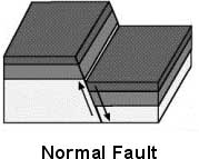
Between Cedar Breaks and the valley below, the Hurricane Fault divides the two provinces. Although movement has occurred along the Hurricane Fault for as long as 30 million years, the most dramatic episode of movement began 10 million years ago. This period of faulting caused a massive block of the earth's crust to drop to the west, forming the level valley far below. It also raised the Markagunt Plateau to its present altitude and exposed the edge of the Claron Formation to the elements. The tension that resulted from this movement caused the rock to crack; these cracks are known as joints.
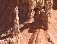 |
| Hoodoo |
What Goes Up...
Rain falls frequently during the Cedar Breaks summer. As it falls, the water combines with carbon dioxide in the atmosphere, forming a weak acid. As this acidic water seeps into the vertical joints, it reacts with the calcium carbonate limestone, dissolving it and progressively widening the cracks into fissures.
When the temperature falls below freezing, water expands, shattering the rock. Roots work their way into the cracks, forcing their edges farther apart. The cracks in turn widen into fissures and then into gullies. Soon, only thin walls, or fins, are left standing under capstones made of harder rock. These capstones act like umbrellas, protecting the fins from the elements and slowing the process of erosion. Eventually erosion wears through the sides of the fins leaving isolated pillars or "hoodoos." Undercutting of cliffs and fins forms shallow caves and arches.
Gravity continually pulls rocks from the cliffs and draws them sliding down the slopes. Water from snowmelt and summer rains wash rock and debris into the valley. Sometimes the upper layers become so saturated with water that the slope fails; the sediments slide as a unit, creating a slump or landslide. Alpine Pond occupies one such slump.
After You Leave Cedar Breaks
- As you drive west towards Cedar City, Highway 14 descends through cliffs of marine and river-borne sandstone deposited near the edge of the Cretaceous sea. As the highway levels out near the mouth of the canyon, you can see rock units that were upended, overturned, and folded by tectonic movement that pre-dated the Hurricane fault.
- As you drive east to Panguitch or Long Valley Junction, you will encounter lava flows, 5,000 to 900 years old. Scanning the horizon, you may spot a cinder cone.
- Most rocks at Bryce Canyon National Park also belong to the Claron Formation, and were deposited in the same ancient lake.
- The rocks of Zion are older than those of Cedar Breaks; they represent the "next step down" in the Grand Staircase. The rocks of the Grand Canyon lie beneath these and are older still.
Copyright © 2005-2006 Calvin & Rosanna Hamilton. All rights reserved.