 |
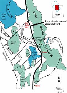
| Map of the major faults and other features surrounding Timpanogos Cave National Monument. |
Timpanogos Cave National Monument
Geologic Setting
The Timpanogos Cave system is located high in the south wall of the American Fork Canyon, about 16 km (10 miles) northeast of the town of American Fork and 24 km (15 miles) north of Provo. The American Fork Canyon area is one small part of the deeply dissected Wasatch Front (the western face of the Wasatch Range) of northern Utah. The Wasatch Front is one of the steepest mountain ranges on earth (Horrocks and Tranel 1994). Rugged mountain faces and narrow, east- west trending, steep- sided canyons characterize the Wasatch Range. Due to rapid regional uplift many of the streams that drain the west side of the Wasatch Front have eroded headward, carving back their canyons, until they now reach the mountain crests.
American Fork Canyon, a steep and narrow streamcut channel in the southern Wasatch Range of North Central Utah, trends east- west, subparallel approximately 32 km (20 miles) to a fault zone responsible for the formation of the Timpanogos Cave complex. Timpanogos Cave National Monument comprises ~0.5 square miles (~250 acres, with an addition of 37 acres per the Timpanogos Interagency Land Exchange Act of 2002) of this canyon in the Uinta National Forest. Displayed on the walls of the canyon and the surrounding peaks are rocks illustrating the history of the area from the Proterozoic Eon to the present day. Although created in 1922 under the 1906 Antiquities Act by President William G. Harding (Proclamation No. 1540) to preserve the speleological treasures deep within the limestone, the monument also preserves a rich history that records the dynamic geologic processes that shaped Earth into its present morphology. The monument, formerly under management of the U.S. Forest Ser! vice, was included in the National Park Service in 1934.
The Wasatch Range is an uplifted crustal block that extends approximately 200 km (125 miles) between Malad City, ID south to Nephi, UT. The range is 13 to 26 km (8 to 16 miles) wide and is bounded dramatically on the west by the prominent scarp of the seismically active Wasatch Fault. The scarp, referred to as the Wasatch Front rises dramatically, some 2,134 m (7,000 ft) in places, from the valley floor below. This front separates the geologic province of the Basin and Range to the west from the Middle Rocky Mountain province to the east.
The Wasatch Range is geologically complex (figure 1). It is characterized by the normal faults along which Basin and Range deformation occurred. Normal faults form when material above the fault surface drops relative to the rocks below the surface. These faults develop as a result of tensional stress in the earths crust and have angles of dip usually between 45- 90º. Because of this relatively high angle, movement along major normal faults often results in dramatic fault scarp surfaces. In addition to the Wasatch Front, this type of fault scarp is demonstrated in the splendid setting of Grand Teton National Park in Wyoming.
There are many parallel ranges throughout the Timpanogos region due to the extensional tectonics pulling the crust apart in a roughly east- west oriented pattern. The Cedar, Oquirrh, and Promontory Ranges to the west of the Wasatch, and the Cricket Mountains, Pavant, and Confusion Ranges to the south and southwest are examples of similar parallel ranges. Basins such as the Tule, Snake, and Great Salt Lake Valleys to the west, and Cedar, and Little Valleys, and Sevier Basin to the southwest are typical examples of fault- bound basins in the Basin and Range province.
Many westward- flowing, high- gradient, nearly parallel streams are dissecting the Wasatch fault scarp into isolated peaks separated by deep, narrow canyons. Mount Timpanogos is one of the more prominent of these isolated peaks, rising to an elevation of 3,581 m (11,750 ft). The slopes of the mountain descend quickly to the valley floor at an elevation of 1,463 m (4,800 ft). The north and east slopes of the mountain are punctuated by a roughly horizontal feature called the Sagebrush Flats, at 2,438 m (8,000 ft).
Timpanogos Cave System
The cave system is composed of three caves called Hansen, Middle, and Timpanogos Caves. They are connected by a series of manmade tunnels to facilitate visitor access. The total combined length of the caves and tunnels is about 1,706 m (5,600 ft), this includes 488 m (1,600 ft) for Hansen Cave, 335 m (1,100 ft) for Middle Cave, and 884 m (2,900 ft) of Timpanogos Cave. The cave elevation is 2,300 m (7,546 ft) above sea level in a nearly vertical southern face in limestone cliffs (St. Clair et al. 1976).
Understanding the geology of the Timpanogos Cave system, the central feature of Timpanogos Cave National Monument, enhances ones understanding of the unique relationship between geology and the environment. The caves consist of high, narrow passageways and rooms developed along an array of minor faults. These faults are just a part of the much larger, complex fault structure near the intersection of the north- south trending Wasatch front and the east- west trending Uinta Mountain fold system to the north of Timpanogos, in northeastern Utah.
The caves have formed in the Deseret Limestone and contain limestone speleothems and are spectacular examples of solution cave dissolution and precipitation processes. The persistent work of acidic water through limestone carved caves into the Wasatch Front. Limestone caves form along ground- water paths of concentrated flow.
During the uplift of the Wasatch Range, 17 Ma, deformation of the Deseret Limestone along faults created the initial fractures and surfaces necessary to start the cave formation (Mayo et al. 2000). Once dissolution of the limestone began, the cave system continued to enlarge along joints, faults, and bedding planes in the rock until it reached its present size and shape. When the cave was later uplifted above the water table, the process of cave decoration began by precipitating limestone into the stalactites, columns, helictites, anthodites, and stalagmites that make the cave famous.
From the geologic map of the Timpanogos Quadrangle one can see that the local geology is extremely complex. The cave lies in an area of block faulting. Some blocks have been displaced nearly 305 m (1,000 ft). In the area around the cave, the minor faults within the blocks dip 15º to 20º to the south. Dipping sediments in the cave suggest that the entire block may have been tilted since cave formation (White and Van Gundy 1974).
References:
Horrocks, R.D., M.J. Tranel. 1994. Timpanogos Cave research project 1991-1992. National Speleological Society News 52 (1): 15-21.
Mayo, A.L., D. Herron, S.T. Nelson, D. Tingey, M.J. Tranel. 2000. Geology and hydrogeology of Timpanogos Cave National Monument, Utah. Utah Geological Association Publication 28: 263- 276.
St. Clair, L.L., S.R. Rushforth. 1976. The diatoms of Timpanogos Cave National Monument, Utah. American Journal of Botany 63 (1): 49-59.
White, W.B., J.J. Van Gundy. 1974. Reconnaissance geology of Timpanogos Cave, Wasatch County, Utah. National Speleological Society Bulletin 30 (1): 5-17.
Copyright © 2003-2006 Calvin & Rosanna Hamilton. All rights reserved.