Zion National Park
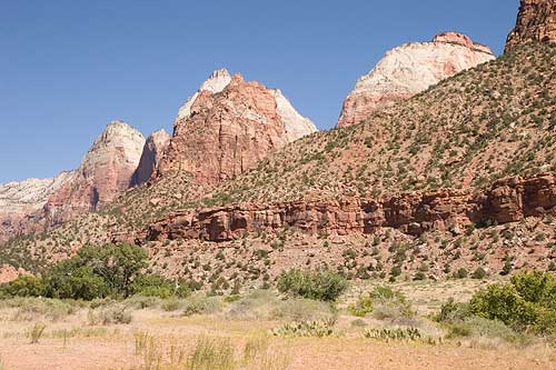
Zion National Park is located along the edge of a region known as the Colorado Plateau. The rock layers have been uplifted, tilted, and eroded, forming a feature called the Grand Staircase, a series of colorful cliffs stretching between Bryce Canyon and the Grand Canyon. The bottom layer of rock at Bryce Canyon is the top layer at Zion, and the bottom layer at Zion is the top layer at the Grand Canyon.
Sedimentation
Zion was a relatively flat basin near sea level 240 million years ago. As sands, gravels, and muds eroded from surrounding mountains, streams carried these materials into the basin and deposited them in layers. The sheer weight of these accumulated layers caused the basin to sink, so that the top surface always remained near sea level. As the land rose and fell and as the climate changed, the depositional environment fluctuated from shallow seas to coastal plains to a desert of massive windblown sand. This process of sedimentation continued until over 10,000 feet of material accumulated.
Lithification
Mineral-laden waters slowly filtered through the compacted sediments. Iron oxide, calcium carbonate, and silica acted as cementing agents, and with pressure from overlying layers over long periods of time, transformed the deposits into stone. Ancient seabeds became limestone; mud and clay became mudstones and shale; and desert sand became sandstone. Each layer originated from a distinct source and so differs in thickness, mineral content, color, and eroded appearance.
Uplift
In an area from Zion to the Rocky Mountains, forces deep within the earth started to push the surface up. This was not chaotic uplift, but very slow vertical hoisting of huge blocks of the crust. Zion's elevation rose from near sea level to as high as 10,000 feet above sea level.
Uplift is still occurring. In 1992 a magnitude 5.8 earthquake caused a landslide visible just outside the south entrance of the park in Springdale.
Erosion
This uplift gave the streams greater cutting force in their descent to the sea. Zion's location on the western edge of this uplift caused the streams to tumble off the plateau, flowing rapidly down a steep gradient. A fast-moving stream carries more sediment and larger boulders than a slow-moving river. These streams began eroding and cutting into the rock layers, forming deep and narrow canyons. Since the uplift began, the North Fork of the Virgin River has carried away several thousand feet of rock that once lay above the highest layers visible today.
The Virgin River is still excavating. Upstream from the Temple of Sinawava the river cuts through Navajo Sandstone, creating a slot canyon. At the Temple, the river has reached the softer Kayenta Formation below. Water erodes the shale, undermining the overlaying sandstone and causing it to collapse, widening the canyon.
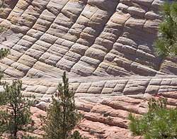 |
| Checkerboard Mesa with horizontal and vertical lines. |
Patterns In the Stone
The Navajo sandstone of Checkerboard Mesa also forms the spectacular cliffs
within Zion. This geographically widespread formation reaches a thickness
of 2,200 feet in the park and consists almost entirely of desert sand
dunes. The Checkerboard Mesa, made of Navajo sandstone, has two sets of
lines forming the checkerboard pattern.
The horizontal lines, commonly called cross bedding, represent layers of wind-blown sand that built up into sand dunes. These dunes were then buried, and the sand grains glued together by calcite and iron oxide to form sandstone. Crossbedding can be seen in many place along the Zion Mt. Carmel Highway.
The vertical lines are less common. They are actually shallow cracks that result from stress and erosion on the rock surface. These cracks are probably caused by expansion and contration, temperature changes, wetting/drying, or a combination of these processes.
Geology-in-Action
A landslide once dammed the Virgin River forming a lake. Sediments settled out of the quiet waters, covering the lake bottom. When the river breached the dam and the lake drained, it left behind a flat-bottomed valley. This change in the character of the canyon can be seen from the scenic drive south of the Zion Lodge near the Sentinel Slide. This slide was active again in 1995, damaging the road.
Copyright © 2005-2008 Calvin & Rosanna Hamilton. All rights reserved.