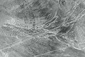
SIA3191: Victory Highway

|
|
Related Documents
Download Options
| Image Name | Width x Height | Size |
|---|---|---|
| SIA3191.jpg | 640 x 428 | 82K |
| SIA3191.jpg | 1200 x 803 | 277K |
| SIA3191.jpg | 2487 x 1665 | 855K |
Caption
This aerial photo has the Trail cutting from lower right to center left of the photo. The white line running diagonally at the bottom is the Victory Highway of the 1920's the dark line is old US 40 before I-80 was built.
Copyright © 2005-2009 Calvin & Rosanna Hamilton. All rights reserved.