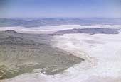
SIA3422: Silver Island Range

|
|
Related Documents
Download Options
| Image Name | Width x Height | Size |
|---|---|---|
| SIA3422.jpg | 640 x 434 | 44K |
| SIA3422.jpg | 1200 x 813 | 141K |
| SIA3422.jpg | 3142 x 2128 | 1M |
Caption
This photo was taken at an elevation of 12,000 feet and shows the Silver Island Range on the left center, it's point on the lower right hand where all the emigrants on this cutoff had to pass. The trail hugged the mountain and crossed the narrow neck of land in the upper center that we now call the Donner /Reed Pass. Crater Island is on the right of center and the mountains in the back are the Pilot Peak Range.
Copyright © 2005-2009 Calvin & Rosanna Hamilton. All rights reserved.