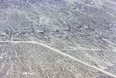
SIA3438: Faint Trail

|
|
Related Documents
Download Options
| Image Name | Width x Height | Size |
|---|---|---|
| SIA3438.jpg | 640 x 432 | 98K |
| SIA3438.jpg | 1200 x 809 | 260K |
| SIA3438.jpg | 2363 x 1592 | 892K |
Caption
This photo shows the faint trail heading down the grade for the last 10 miles across the last playa to Donner Springs. The faint trail is a straight line from the road in the left center to just below the center of the photo on the right.
Copyright © 2005-2009 Calvin & Rosanna Hamilton. All rights reserved.