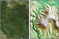
SIA4165: Fort Hill - The Power of LIDAR

|
|
Related Documents
Download Options
| Image Name | Width x Height | Size |
|---|---|---|
| SIA4165.jpg | 1400 x 966 | 326K |
| SIA4165.jpg | 2897 x 1998 | 1M |
Caption
Both pictures cover exactly the same area of Fort Hill, a Native American fortified hill built by the Hopewell Indians nearly 2000 years ago. On the left is USGS Imagery in which all you can see is vegetation. On the right is LIDAR data processed by ScienceViews.com. This data has been processed to see beneath the tree canopy, or the view of the ground. In LIDAR the earthen banks that once formed a palisade (fence) around the entire hilltop is very visible. Even the breaks in the walls where towers once stood are visible. Compare it to E.G. Squier's survey map of Fort Hill (SIA3594) completed in 1846.
Copyright © 2005-2018 Calvin & Rosanna Hamilton. All rights reserved.