

PLATE V  Open in Google Earth
"Fort Hill," Highland County, Ohio12
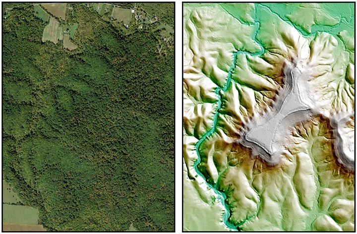
On the left is satellite imagery of Fort Hill and on the right is Lidar imagery showing the fortified earthen banks along the hilltop.
THIS work occurs in the southern part of Highland county, Ohio; and is distant about thirty miles from Chillicothe, and twelve from Hillsborough. It is universally known as "Fort Hill," though no better entitled to the name than many others of similar character. The defences occupy the summit of a hill, which is elevated five hundred feet above the bed of Brush creek at its base, and eight hundred feet above the Ohio river at Cincinnati. Unlike the hills around it, this one stands detached and isolated, and forms a conspicuous object from every approach. Its sides are steep and precipitous; and, except at one or two points, if not absolutely inaccessible, extremely difficult-of ascent. The points most easy of access are at the southern and northern angles, and may be reached on horseback. The top of the hill is level, and has an area of not far from fifty acres, which is covered with a heavy primitive forest of gigantic trees. One of these, a chestnut, standing on the embankment near the point indicated by the letter e, measures twenty-one feet in circumference; another, an oak, which also stood on the wall, at the point f, though now fallen and much decayed, still measures twenty-three feet in circumference. All around are scattered the trunks of immense trees, in every stage of decay; the entire forest presenting an appearance of the highest antiquity.
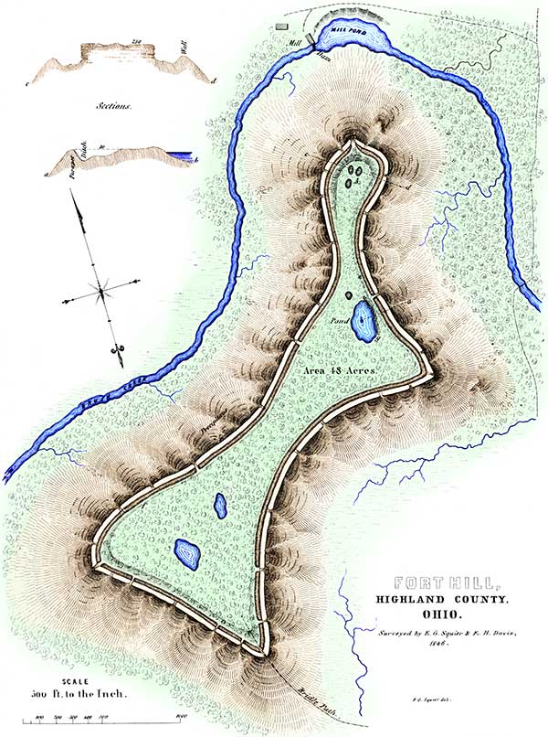
Thus much for its natural features. Running along the edge of the hill is an embankment of mingled earth and stone, interrupted at intervals by gateways. Interior to this is a ditch, from which the material composing the wall was taken. The length of the wall is eight thousand two hundred and twenty-four feet, or something over a mile and a half. In height, measuring from the bottom of the ditch, it varies from six to ten feet, though at some places it rises to the height of fifteen feet. Its average base is thirty-five or forty feet. It is thrown up somewhat below the brow of the hill, the level of the terrace being generally about even with the top of the wall; but in some places it rises considerably above, as shown in the sections. The outer slope of the wall is more abrupt than that of the hill; the earth and stones from the ditch, sliding down fifty or a hundred feet, have formed a declivity for that distance, so steep as to be difficult of ascent, even with the aid which the trees and bushes afford. The ditch has an average width of not far from fifty feet; and, in many places, is dug through the sandstone layer upon which the soil of the terrace rests.13 At the point A, the rock is quarried out, leaving a mural front about twenty feet high. The inner declivity of the ditch appears to have been terraced. It descends abruptly from the level for a few feet, then declines gently for some distance, and again dips suddenly, as it approaches the wall. The vertical section a b exhibits this feature.
There are thirty-three gateways or openings in the wall, most of them very narrow, not exceeding fifteen or twenty feet in width at the top: only eleven of these have corresponding causeways across the ditch. They occur at irregular intervals; and some of them appear to have been rather designed to let off the water which might otherwise accumulate in the ditch, than to serve as places of egress or ingress. Indeed, most of them cannot be supposed to have been used for the last named purposes, inasmuch as they occur upon the very steepest points of the hill, and where approach is almost impossible. At the northern and southern spurs or angles of the hill, the gateways are widest, and the parapet curves slightly outwards. The ditch is interrupted at these points.
There are three depressions or ponds within the enclosure; the largest of these, g, has a well-defined artificial embankment on its lower side, which has recently been cut through, and the water principally drawn off. When full, the water must have covered very nearly an acre. Bog-clumps are growing around its edges, and it is free from trees. It does not seem to have any perennial sources of supply. There are several other small circular depressions, a number of which occur together at the bluff A; there are also traces of other excavations, not clearly defined, at various points on the hill.
An inspection of the plan of the work, shows that it is naturally divided into three parts; that at A being, in many respects, the most remarkable. It is connected with the main body of the work by a narrow ridge but one hundred feet wide, and terminates at a bold, bluff ledge, the top of which is thirty feet above the bottom of the trench, and twenty feet above the wall. This bluff is two hundred feet wide. It is altogether the most prominent point of the hill, and commands a wide extent of country. Here are strong traces of the action of fire on the rocks and stones; though whether remote or recent, it is not easy to determine. The connection between the two principal divisions of the work is also narrow, being barely two hundred and fifty feet in width.
Such are the more striking features of this interesting work. Considered in a military point of view, as a work of defence, it is well chosen, well guarded, and, with an adequate force, impregnable to any mode of attack practised by a rude, or semi-civilized people. As a natural stronghold, it has few equals; and the degree of skill displayed and the amount of labor expended in constructing its artificial defences, challenge our admiration, and excite our surprise. With all the facilities and numerous mechanical appliances of the present day, the construction of a work of this magnitude would be no insignificant undertaking. And when we reflect how comparatively rude, at the best, must have been the means at the command of the people who raised this monument, we are prepared to estimate the value which they placed upon the objects sought in its erection, and also to form some conclusion respecting the number and character of the people themselves.
It is quite unnecessary to recapitulate the features which give to this the character of a military work; for they are too obvious to escape attention. The angles of the hill form natural bastions, enfilading the wall. The position of the wall, the structure of the ditch, the peculiarities of the gateways where ascent is practicable, the greater height of the wall where the declivity of the hill is least abrupt, the reservoirs of water, the look-out or citadel, all go to sustain the conclusion.
The evidence of antiquity afforded by the aspect of the forest, is worthy of more than a passing notice. Actual examination showed the existence of not far from two hundred annual rings or layers to the foot, in the large chestnut-tree already mentioned, now standing upon the entrenchments. This would give nearly six hundred years as the age of the tree. If to this we add the probable period. intervening from the time of the building of the work to its abandonment, and the subsequent period up to its invasion by the forest, we are led irresistibly to the conclusion, that it has an antiquity of at least one thousand years.14 But when we notice, all around us, the crumbling trunks of trees half hidden in the accumulating soil, we are induced to fix upon an antiquity still more remote.
It is worthy of note, that this work is in a broken country, with no other remains, except perhaps a few small, scattered mounds, in its vicinity. The nearest monuments of magnitude are in the Paint creek valley, sixteen miles distant, from which it is separated by elevated ridges. Lower down, on Brush creek, towards its junction with the Ohio, are some works; but none of importance occur within twelve miles in that direction.
12. This work was first described, though not first surveyed, by Professor Looms, of Cincinnati, in 1838. His description and plan—to the accuracy and fidelity of which every visitor can bear witness—were published in the "Second Annual Report of the Geological Survey of Ohio."
13. This sandstone, it should be remarked, to prevent misapprehension, is the "Waverley sandstone," underlying the coal series, and which is found capping most of the hills in this region. It occurs in successive layers, of from a few inches to several feet in thickness. It is quite friable, and quarries readily.
14. "One of the mounds at Marietta must be more than eight hundred years old ; for Dr. Hildreth counted eight hundred rings of annual growth in a tree which grew upon it. "—Lyel1's Travels in North America, vol. ii. p. 29. See also Second Geological Report of the Stale of Ohio. p. 269.
Copyright © 2009 Calvin & Rosanna Hamilton. All rights reserved.