

PLATE XXXVII.
Remains on the Wateree River, Kershaw District, South Carolina.
 It is unquestionable that the race of the mounds occupied a portion of the State
of South Carolina; and although the traces of their occupation are far from abundant, they are still sufficiently numerous to deserve notice. The only reliable
information we have concerning them, is contained in a MS. letter from William
Blanding, M. D., late of Camden, South Carolina, a gentleman distinguished for
his researches in natural history, to Samuel George Morton, M. D., of Philadelphia, the eminent author of "Crania Americana," by whose permission it is
embodied in this connection. The observations of Dr. Blanding were confined to
a section of the valley of the Wateree river, embracing about twenty-five miles
in the immediate vicinity of Camden, and mainly included in the Kershaw district.
It is unquestionable that the race of the mounds occupied a portion of the State
of South Carolina; and although the traces of their occupation are far from abundant, they are still sufficiently numerous to deserve notice. The only reliable
information we have concerning them, is contained in a MS. letter from William
Blanding, M. D., late of Camden, South Carolina, a gentleman distinguished for
his researches in natural history, to Samuel George Morton, M. D., of Philadelphia, the eminent author of "Crania Americana," by whose permission it is
embodied in this connection. The observations of Dr. Blanding were confined to
a section of the valley of the Wateree river, embracing about twenty-five miles
in the immediate vicinity of Camden, and mainly included in the Kershaw district.
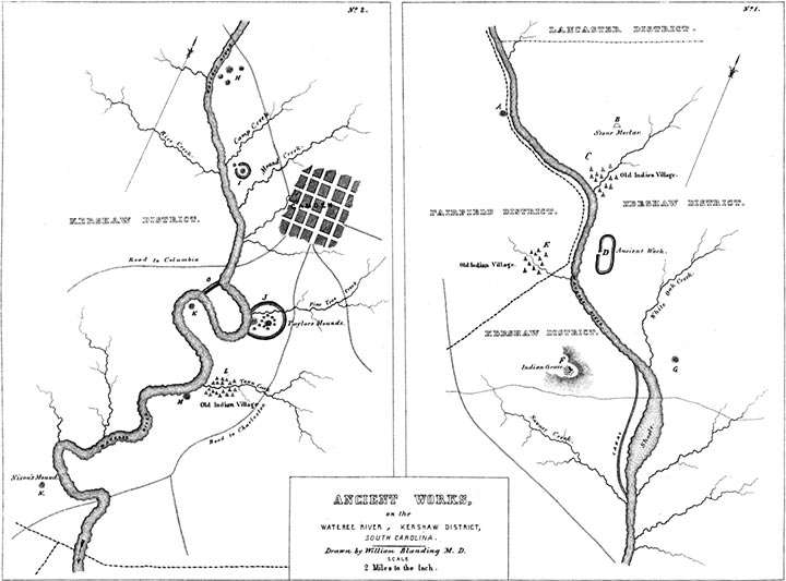
"The first monument deserving of notice is 'Harrison's Mound' (A in the Map). It is the highest in position of any on the river, and is situated on the west side of the same, in the Fairfield district. It is about four hundred and eighty feet in circumference at the base, fifteen feet high, and has a level area one hundred and twenty feet in circumference at its summit.
"The next relic of antiquity is the 'Indian Mortar,' (B in the Map,) in the Kershaw district. It is a regular bowl-shaped excavation in a solid block of granite, holding upwards of half a bushel, and is evidently the work of art. It was used as a mortar by the early settlers, and is still devoted to the same purpose. The part of the rock projecting out of the ground is equivalent to eight or ten tons.
"Next is an old Indian town or camp near the mouth of Beaver creek (C in the Map). A little below the mouth of the creek is an old fortification, of oblong form, consisting of a wall and ditch (D in the Map). The embankment is now not more than three feet high above the level of the plain. The ditch is distinct. Nearly opposite this work, on the west side of the river, are the traces of an old Indian village, remarkable for its arrow-heads, fragments of pottery, etc.
"Proceeding down the river, we come to a point near the head of the canal, where the land rises to the extraordinary height of five hundred feet, forming a long, narrow hill. Upon the point of this hill nearest the river, stands what is called the 'Indian Grave' (F in the Map). It is composed of many tons of small round stones, weighing from one to four pounds each. The pile is thirty feet long from east to west, twelve feet broad, and five feet high, so situated as to command an extensive view of the adjacent country, stretching as far as Rocky Mount, twenty miles above, and for a long distance below on the river. It may be suggested that this is the elevated burial-place of some great chief, or that it was designed as some sort of an observatory. The Catawba Indians can give no account of it, nor will they venture a conjecture as to its purposes. A mound, G, is situated opposite this stone heap, on the other side of the river. The 'shoals' in the immediate vicinity seem to have been a favorite haunt of the ancient and more recent races. Here to this day is to be found an abundance of fish and game, and the vicinity is marked by numerous aboriginal relics. Here also is the highest boundary of the long-leaved pine, and the limit of the alluvial region. Below, the river becomes sluggish, and during high water leaves its banks and spreads over large tracts of land.
"The mound next below, H, was two hundred and fifty feet in circumference at the base, seventy-five feet at the top, and thirteen feet high. It was situated about a hundred yards from the river on lands subject to overflow. Three other small mounds surrounded it. In 1826 it was levelled, and the material used for manuring the adjacent lands. A part of the treasures which it contained were saved, but the rest are scattered or destroyed. The mound presented, upon excavation, a succession of strata, varying in thickness from six inches to one foot, from top to base. First vegetable loam, then human and animal bones, followed by charcoal of reeds, vessels of clay and fragments of the same, (some holding not more than one pint,) arrow-heads and stone axes, then earth, etc., alternately. In one small vessel was found a tag or needle made of bone, supposed to have been used in making dresses. Near it was found the skeleton of a female, tolerably entire, but which fell in pieces on exposure. A stratum of dark-colored mould was mixed with these articles; perhaps decomposed animal matter. The superstructure of the mound was the alluvial loam, and constituted tolerable manure. It was mixed with great quantities of mica, some pieces three or four inches square. Marine shells, much decomposed, were found in this as in other mounds, mixed with the bones, from top to bottom.
"Descending the river, near Mound creek, we come to a large mound, I, enclosed in a circle, and accompanied by a smaller one. It is perhaps the largest and most perfect on the river. It is five hundred feet in circumference at the base, two hundred and twenty-five feet in circumference at the summit, and thirty-four feet high,—slightly oblong. It is covered with stumps, briars, etc., having recently been brought under cultivation. In April last, while ploughing over the small mound, an urn was discovered, a sketch of which is enclosed. It holds forty-six quarts, or nearly twelve gallons. It had a cover fitting closely over the body for about six inches; this was broken by the plough. The vessel was curiously ornamented, and is probably the largest ever discovered in the valley. It contained a number of large shell beads, much decomposed, about the size and shape of nutmegs. It also contained another article of the same material, about the size of a man's palm, a quarter of an inch thick, and carved in open work; probably designed for suspension around the neck as a badge or ornament. The ditch around this mound is slight.
"Still further down the river, upon the opposite side, and some distance south of the road from Camden to Columbia, is the most remarkable ancient work in the valley (O). It is called the 'Indian Ditch.' It occurs at the great bend of the river, and consists of an embankment and ditch carried across the isthmus, cutting off, and, with the river, enclosing some hundreds of acres of fine alluvial land. It is about one mile in length, and the circuit of the river from one end to the other is between three and four miles. Twenty-one years ago, when 1 first visited it, this ditch was about eight feet deep and the wall of corresponding dimensions: a primitive forest was then growing upon its southern portion, but it is now all under the plough and fast disappearing. The bank is exterior to the ditch, which circumstance seems to conflict with the notion that the work was constructed for defence. It has been suggested, but with no good reason, that it was designed for a 'cut off'' or artificial channel for the river. Whatever its purpose, it was a great undertaking for a rude or savage people.
"On the opposite side of the river, about two hundred yards below the mouth of Pine-tree creek, is a group of mounds, surrounded by a low embankment (J). One of them has been nearly washed away by the river, and the others have been much reduced by cultivation. The largest is yet twelve or fifteen feet high, with a very wide base. From these mounds are disclosed arrow-heads, axes, urns, and other vestiges of art, accompanied by human bones and the bones of wild animals, and marine shells, all much decayed. As the water washes away the side of the mound on its bank, charcoal, urns, bones, etc., in successive strata, are exposed; as though it had constituted a cemetery, receiving deposits from time to time, from its commencement to its completion. The strata vary in thickness from six to eighteen inches, and are mixed with much mica, sometimes in large plates. It was long under cultivation in corn, then indigo, and in 1806, when I first saw it, in cotton, which is still cultivated on it. On the large mound stood the overseer's house; around it, on the smaller piles, were the negro quarters.
"In the bend of the river nearly opposite the south end of the 'Indian Ditch,' is a mound, perhaps fifteen feet high (K). Little is known respecting it, having been for many years the site of an overseer's house. I obtained a circular stone, with concave sides and finely polished, which had been found here, also two large urns, one holding twelve, the other twenty quarts, with a number of other aboriginal relics. At the mouth of Town creek, some distance below, there was formerly, no doubt, an Indian town or camp, (L,) judging from the quantity of relics found here. A very fine description of clay is found at this spot, which is resorted to by the Catawba Indians every spring and autumn, for the purpose of manufacturing pottery from it.
"Boykin's mound (M) is one mile lower down the river upon the same bank. It is now nearly washed away by the river. Twenty years ago, when I first saw it, large trees covered it, and it was entire. Four years afterwards I visited it, when only about one third remained, which on the side next the river beautifully exhibited the various strata composing it. It had the usual layers of earth, pottery, charred reeds, etc. Some few of the vases were entire, containing fragments of bones, and were well arranged in tiers, one above the other.
"Last of the series is Nixon's mound (N). It is much reduced, and is not now more than ten feet high. From this to the sea I know of no similar relics. Paint hill and Kirkwood, in the neighborhood of Pine-tree creek, must have been much frequented, judging from the numerous relics occurring on and around them; the former for its pure water, the latter for its fine clay. Hobkirk's hill, near Camden, abounds in aboriginal relics. I have procured several large pipes from these localities, all of which exhibit a skill in workmanship surpassing that of the present race. The entire section in which the above remains occur is exceedingly fertile, and capable of sustaining a large agricultural population."
Copyright © 2010 Calvin & Rosanna Hamilton. All rights reserved.