PLATE IX. No. 1.
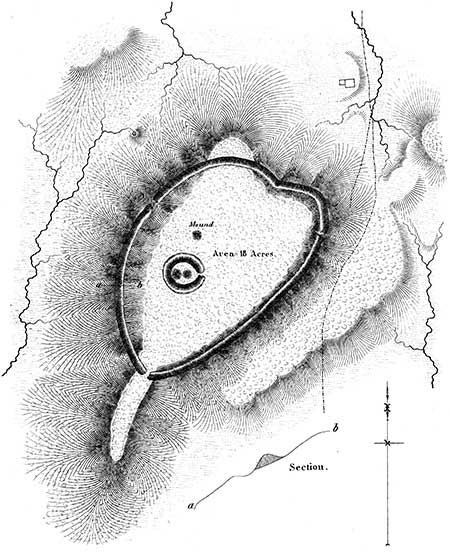
Fortified Hill, Near Granville, Licking County, Ohio.
THE work here represented is situated two miles below the town of Granville, Licking county, Ohio. It encloses the summit of a high hill, and embraces an area of not far from eighteen acres. The embankment is, for the most part, carried around the hill at a considerable distance below its brow, and is completely overlooked from every portion of the enclosed area. Unlike all other hill-works which have fallen under notice, the ditch occurs outside of the wall; the earth in the construction of the latter having been thrown upwards and inwards. This is observed equally at the points where the hill is steepest; and the result has been, in the lapse of time, that the ditch is almost obliterated, while the accumulating earth has filled the space above the wall, so that the appearance of the defence, at these points, is that of a high, steep terrace. The height of the wall varies at different places; where the declivity is gentle and the approach easy, it is highest,—perhaps eight or ten feet from the bottom of the ditch; elsewhere it is considerably less. The embankment conforms generally to the shape of the hill. It is interrupted by three gateways, two of which open towards springs of water, and the other, or principal one, upon a long narrow spur, which subsides gradually into the valley of Raccoon creek, affording a comparatively easy ascent.
Upon the highest part of the ground enclosed in this work, is a small circle, one hundred feet in diameter, within which are two small mounds. There is also another truncated mound, a little distance to the northward of the circle. The mounds within the circle, upon excavation, were found, in common with all similar structures occurring within enclosures, to contain altars. No enduring remains seem to have been deposited upon these altars, which were covered with ashes, intermixed with small fragments of pottery. This is the only hill-work which has been observed to embrace a minor work of the description here represented. The character of the principal enclosure can hardly be mistaken; it is palpably a defensive work, although deficient in that grand essential, a supply of water. If we concede, what can hardly admit of doubt, that the minor structure had a sacred or superstitious origin, we must of necessity arrive at the conclusion that the altars of the ancient people sometimes accompanied their defences.
This work constitutes one of the Newark Group, and is indicated by the letter B in the "Map of six miles of the Newark Valley," presented upon a succeeding plate. This section of country was once densely populated, as is evidenced by the number and extent of the ancient remains which it includes; and it is probable that the work here noticed, together with one of like character upon the opposite side of the valley, three miles distant, constituted the places of last resort of the ancient inhabitants. The extensive works in the immediate vicinity of Newark, of which a full account is elsewhere given, can hardly be supposed to partake of a military character.
PLATE IX. No. 2.20
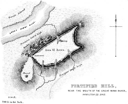
Fortified Hill at the Mouth of the Great Miami River, Hamilton County, Ohio.

THIS work is strictly analogous to the other hill-works already described, and is so well exhibited in the engraving as to need little explanation. It occupies the summit of a steep, insulated hill, and consists of a wall carried along its brow, composed of earth, thrown as usual in such cases from the interior. The wall conforms strictly to the outline of the hill, except at the west, where there is a considerable promontory, which is left unenclosed. Upon this promontory is a mound, corresponding doubtless in its purposes with the one on the principal avenue of approach to the remarkable fortified hill, higher up on the Miami, in Butler county (Plate VI.) The late President Harrison regarded this work as admirably designed for defence, and as evincing extraordinary military skill. He says:
"The work at the mouth of the Great Miami was a citadel, more elevated than the Acropolis of Athens, although easier of access, as it is not like the latter a solid rock, but upon three sides is as nearly perpendicular as could be, to be composed of earth. A large space of the low ground was, however, enclosed by walls uniting it with the Ohio. The foundation of that (being of stone as well as those of the citadel) which formed the western defence, is still visible where it crosses the Miami river, which, at the period of the erection of the work, must have discharged itself into the Ohio at a point much lower down than it now does. I have never been able to discover the eastern wall of the enclosure; but if its direction from the citadel to the Ohio was such as it should have been, to embrace the largest space with the least labor, there could not have been less than three hundred acres enclosed."21
PLATE IX. No. 3.
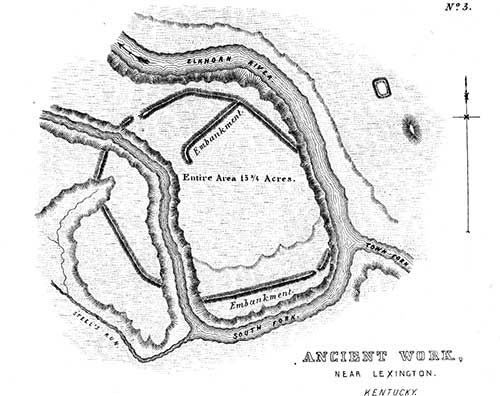
Ancient Work Near Lexington, Kentucky.
[From the RAFINESQUE MSS. ]

20. The above plan is copied from the map accompanying Harrison's published Address before the Historical Society of Ohio.—Transactions,vol. I. p. 217.
21. Transactions Historical Society of Ohio, vol. i. p. 225.
22. This work is not placed in the connection which it was designed to occupy. Its position in the text was determined by circumstances; and its character will be better understood in the progress of this chapter.


