| E.G. Squier |
Ancient Monuments |
Table of Contents |
All Plates |
Hopewell Mound Group Photos |
 •
•

•
PLATE X.
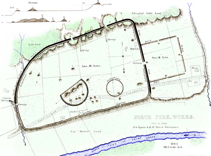
Clark's Work; North Fork of Paint Creek23
[Today this site is known as the "Hopewell Mound Group." All of the internal mound structures have been destroyed, but parts of the walls and ditches can still be seen up on the table land.]
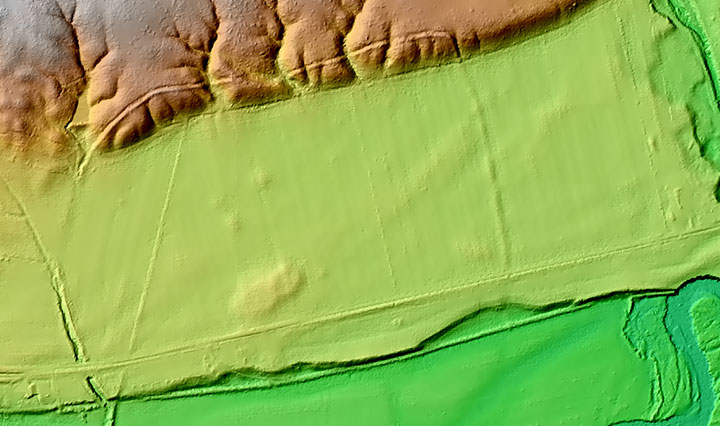
[This is a Lidar image of the Hopewell Mound Group. The northern ditches and berms are clearly visible as well as the eastern berm. The square has been destroy as well as all the mounds within the enclosure; however, the location of the mounds are still visible because not all of the soil was removed.]
THE work here presented is one of the largest and most interesting in the Scioto valley. It has many of the characteristics of a work of defence, and is accordingly classified as such, although differing in position and some other respects from the entrenched hills just described. The minor works which it encloses, or which are in combination with it, are manifestly of a different character, probably religious in their design, and would seem to point to the conclusion, that this was a fortified town, rather than a defensive work of last resort.It is situated on the North fork of Paint creek, on the estate of W. C. CLARK, Esq. and occupies the entire width of the second terrace, which here presents a broad and level plain, of exceeding beauty and fertility. Its general form is that of a parallelogram, twenty-eight hundred feet by eighteen hundred, with one of its corners somewhat rounded. On the side next the creek, it is bounded by a wall tour feet high, running along the very edge of the terrace-bank, and conforming to its irregularities; these however are slight. Its remaining sides are bounded by a wall and exterior ditch; the wall is six feet high by thirty-five feet base, and the ditch of corresponding dimensions. The lines ascend the declivity of the table land back of the terrace, and extend along its brow, dipping into the ravines and rising over the ridges into which it has been cut by the action of water. Wherever the ravines are of any considerable depth, the wall has been washed away; but in all cases leaving evidences that it once extended uninterruptedly through. The bank of the terrace is thirty, that of the table-land fifty feet in height.
The area thus enclosed is one hundred and eleven acres. To the right of the principal work, and connecting with it by a gateway at its centre, is a smaller work of sixteen acres area. It is a perfect square; its sides measuring respectively eight hundred and fifty feet. It has gateways at the middle of each side, thirty feet wide, and covered by small mounds, which are placed fifty feet interior to the walls. There are gateways also at the two outer corners, which are unaccompanied by mounds. The opening which leads to the principal enclosure is twice as wide as the others. The walls of the smaller work are much lighter than those of the large one, and have no attendant ditch.
 |
| Figure 3. |
Where the defences descend from the table lands to the left, is a gully or torrent-bed, which, before the construction of this work, kept the course indicated by the dotted line x. It was turned by the builders from its natural channel into the ditch, along which it still runs for a considerable distance; but at one place it has broken over the wall, obliterating it for nearly two hundred feet. It is dry at most seasons of the year; and, unless much swollen by the rains, keeps the course of the ditch, terminating in a deep gully, formed by the flow of water from a copious and unfailing spring. This gully is made to answer as a ditch, for the space yet intervening, to the edge of the terrace. It is fifteen feet deep, by sixty or seventy wide. In several other instances, this artificial change in water-courses has been observed.
The gateways of this work are six in number; one opening into the smaller enclosure to the east, two upon the table lands, one to the spring first mentioned, and two others towards the creek. Two considerable springs occur within the walls. It is not necessary, however, upon the hypothesis already advanced in respect to this work, to suppose its ancient population wholly dependent upon these sources for their supply of water; inasmuch as it is very evident that many centuries have not elapsed since the creek, now one hundred rods distant, washed the base of the terrace upon which it stands. Indeed, until recently, and until prevented by dykes above, the creek at its highest stages continued to send a portion of its waters along its ancient channel.
The slight wall along the terrace bank is composed chiefly of smooth, water-worn stones, taken from the creek, and cemented together by tough, clayey earth. The wall of the square is wholly of clay, and its outlines may be easily traced by the eye, from a distance, by its color. It appears, as do the embankments of many other works, to have been slightly burned. This appearance is so marked, as to induce some persons to suppose that the walls were, in certain instances, originally composed of bricks partially baked, but which have in process of time lost their form, and subsided into a homogeneous mass. That they have in some cases been subjected to the action of fire, is too obvious to admit of doubt. At the point z in the lower wall of the square, stones and large masses of pebbles and earth, much burned, and resembling a ferruginous conglomerate, are turned up by the plough. May not this feature be accounted for by supposing the walls to have been originally surmounted by palisades, which were destroyed by the action of fire? Such a cause, however, seems hardly adequate to produce so striking results.
The broken table land upon which the main work extends, forms natural bastions at T and S, which have gateways opening to them. At the point marked C in the embankment, a quantity of calcined human bones are observable.
Such are some of the features of this interesting work; and if their detail has been tedious, it may be urged in extenuation of such minuteness, that descriptions have hitherto been quite too vague and general. Minute circumstances are often of the first importance in arriving at correct conclusions. The comparative slightness of the wall and the absence of a ditch, at the points possessing natural defences,—the extension of the artificial defences upon the table lands overlooking and commanding the terrace,—the facilities afforded for an abundant supply of water, as well as the large area enclosed, with its mysterious circles and sacred mounds,—all go to sustain the conclusion, that this was a fortified town or city of the ancient people. The history of its fall, if its strange monuments could speak, would perhaps tell of heroic defence of homes and altars, and of daring achievements in siege and assault.
The amount of labor expended in the construction of this work, in view of the imperfect means at the command of the builders, is immense. The embankments measure together nearly three miles in length; and a careful computation shows that, including mounds, not less than three millions cubic feet of earth were used in their composition.
Within this work, some of the most interesting discoveries recorded in this volume were made.
23. This plan is from an original, minute survey by the authors. A plan and description of the same work were published by Mr. Atwater in the "Archaeologia Americana." It will be found to differ in some important respects.
Copyright © 2009 Calvin & Rosanna Hamilton. All rights reserved.