

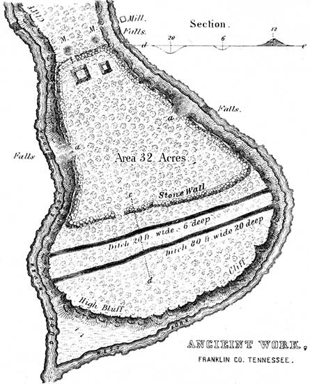
PLATE XII. No. 1.
Stone Work, on Duck River, Tennessee24
THIS work is situated in Franklin county, Tennessee, at the junction of the east and west branches of Duck river, and near the main road from Nashville to Winchester.
"It includes an area of about thirty-two acres. The walls are composed of stones of various sizes, collected from the surface of the surrounding country, and rudely thrown together; there is no appearance of their having been united by cement, nor do they exhibit any marks of the hammer. The wall on the south is covered with a layer of earth from one to two feet deep, and is about sixteen feet in thickness at the base, about five feet at the top, and from eight to ten feet high.
"At the northern extremity, near the front wall, are two conical mounds of stone, designated by M, M, in the plan. Each of these mounds is about six feet high, and ten feet in diameter at the base; originally they may have been of somewhat greater altitude, and being on the exterior of the wall, may have been intended as watch towers. In the rear of the mounds is the northern wall, extending to a high bank on either branch of Duck river, and opposite to a waterfall on each, of ten or twelve feet in height. In the northern wall is an entrance or gateway, and in the rear of the gateway are what appear to be the remains of two stone buildings (exaggerated in the plan), one about sixteen feet square, the other about ten feet; the stones are rough and unhewn. Stretching south, the walls are continued on both sides until they reach the points a a, at a bold limestone bluff, which forms a good natural defence. South of the bluff the walls are continued of the same height and thickness, until they reach the angles of the wall fronting the south which wall also extends from the bank of one river to the other, and has a gateway nearly opposite to that in the northern wall. At the points a a, it is supposed by many who have examined this work, there were formerly excavated passages leading to each branch of Duck river, with steps cut in the rock. There does not, however, appear to be sufficient evidence to sustain this conclusion. The ascent or descent is not very difficult; the steps appear to be formed by the projection of the rock strata; and it was no doubt by these passages that the occupants of the work gained access to the river, and were supplied with water.
"Near the base of the wall on the south side is a ditch, from sixteen to twenty feet wide, and six or eight deep. A short distance farther from the southern wall is another and much more extensive ditch or excavation. In some places it is seventy or eighty feet wide, and from twenty-five to thirty feet deep. The earth from these ditches was probably removed to cover the walls of the fort, or employed in the erection of the neighboring mounds, while the ditches themselves constituted an additional means of defence.
"About three quarters of a mile north of this work is a mound of an oblong form, about twenty-five feet high, one hundred feet long, and twenty broad. On the north-west, about half a mile distant, is another mound of similar form, twenty feet high, eighty long, and sixty wide. These mounds are constructed with the same regularity that distinguishes all the other works of similar character. On both these mounds, trees are growing as large as any in the surrounding forests.
"This work differs in its form, and in the material used in its construction, from all others in the vicinity; but it does not exhibit greater evidence of skill. The difference in form was probably owing to its location; it having evidently been made to conform in all respects to the nature of the ground. Stones were employed because they could be readily procured. Although the hammer had nothing to do with the preparation of the materials, it was nevertheless a work of great labor, and the place of location was selected with a military eye."
Numerous other defensive works are represented to exist in Tennessee; but very few of them have been surveyed and described. In Bedford county there is a stone work of considerable size, the walls of which are said, to be from sixteen to twenty feet wide at the base, and four to five feet wide on the top. Other works adjoin it. It is generally believed to have been erected by De Soto; but in 1819 an oak-tree standing on the wall was cut down, which exhibited three hundred and fifty-seven annual layers, and must consequently have been seventy-eight years old when De Soto landed in Florida.25
A stone work, less in size, but of the same general character, occurs in Larue county, Kentucky. It is situated on one of the bluffs of the Rolling Fork of Salt river, where the creek makes a sharp bend. A plan of it is published in Collins's History of Kentucky, p. 398. An account of another, of much the same character, in Allen county, is published in the same work, p. 167.
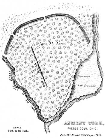
PLATE XII. No. 2.
[You can see a vague trace of this site in the field. GPS: 39.71596824, -84.52368021]
THIS work is situated at the junction of the two principal forks of Twin creek, an affluent of the Great Miami river, six miles south-east of the town of Eaton, Preble county, Ohio, on S. E. corner of Sec. No. 10, Township 5, of Range 3, E. M. The plan is from a survey by Mr. McBride.
In position and mode of construction, this work does not differ materially from a number of others already described. The embankment has an average height of about four feet, and the ditch is not far from five feet deep. The bluff bordering upon the Franklin fork of the creek is for the most part precipitous, and has an average height of between fifty and sixty feet. At its base are several never-failing springs. The height of the bluff fronting upon the other fork varies from thirty feet near the end of the wall, to sixty feet at the junction of the two streams. At its highest part, the bluff consists of a conglomerate, composed of gravel and stones of considerable size. It is very porous, and overhangs about ten feet. There are a number of large cavities in it, which were once supposed to be artificial, and the entrances to subterranean chambers. They are formed by the disintegration of the materials composing the bluff.
Nearly in the centre of the work, in the position indicated in the plan, is a line of large stones. They occupy a space about seven hundred feet long, by twelve broad, and are laid compactly together. Though much sunk in the earth, they are yet distinctly traceable.
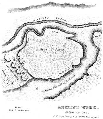
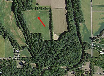
PLATE XII. No. 3.26
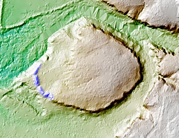
[This is a lidar image of the Pollock Works as it appears today. Part of the earthworks are still visible. GPS: 39.7394931, -83.8250398]
THE fortification here presented affords a fine illustration of the character of the ancient defences of the West. It is situated on Massie's creek, a tributary of the Little Miami river, seven miles east from the town of Xenia, Greene county, Ohio; and consists of a high promontory, bounded on all sides, excepting an interval at the west, by a precipitous limestone cliff. Across the isthmus, from which the ground gradually subsides towards the plain almost as regularly as an artificial glacis, is carried a wall of earth and stones. This wall is now about ten feet high by thirty feet base, and is continued for some distance along the edge of the cliff where it is least precipitous, on the north. It is interrupted by three narrow gateways, exterior to each of which was formerly a mound of stones, now mostly carried away. Still exterior to these are four short crescent walls, extending across the isthmus. These crescents are rather slight, not much exceeding, at the present time, three feet in height. The cliff has an average height of upwards of twenty-five feet, and is steep and almost inaccessible. At d d are breaks in the limestone, where the declivity is sufficiently gentle to admit of a passage on horseback. At E is a fissure in the cliff, where persons may ascend on foot. The valley, or rather ravine, C C, is three hundred feet broad. Massie's creek, a considerable stream, washes the base of the promontory on the north. The area bounded by the cliff and embankment is not far from twelve acres. The whole is now covered with the primitive forest.
The natural strength of this position is great, and no inconsiderable degree of skill has been expended in perfecting its defences. A palisade, if carried around the brow of the cliff and along the summit of the wall, would render it impregnable to savage assault. About one hundred rods above this work, on the opposite side of the creek, is a small circle, two hundred feet in diameter, enclosing a mound. About the same distance below, upon the same bank, is a large conical mound, thirty feet in height and one hundred and forty feet in diameter at the base. No other works of magnitude are known to exist, nearer than the great defensive structure on the Little Miami (Plate VII.), twenty-one miles distant.
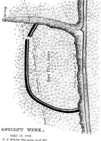
PLATE XII. No. 4.
This work, unlike those just described, occurs upon the high table-land bordering the Scioto river bottoms, on the west bank of that stream, twelve miles above the city of Chillicothe. It consists of a single wall and ditch, cutting off a high promontory, formed by the declivity of the table land, and the bank of a wide and deep ravine. These banks are not far from one hundred feet in height, and at most points are absolutely inaccessible. It has a single gateway, opening towards a copious spring, at the head of the ravine just mentioned. The wall is four feet high, and the ditch of corresponding depth. There are no mounds within this enclosure, nor in its immediate vicinity; but a number of natural elevations are discernible, which an unpractised eye might mistake for works of art. In this instance, they may have subserved some of the purposes of the mounds. The water flowing through the ditch has formed deep gullies at the points where it terminates. The soil is here clayey and hard. The level at the foot of the promontory upon which this work stands, is the first or latest-formed terrace of the Scioto; indicating that the river, at one period, swept along where the Ohio canal now passes.
24. Two plans of this work exist among the MSS. of Rafinesque, which differ slightly from each other. One of them coincides, however, in all important particulars with a plan published some years ago in the "Western Messenger," and has therefore been adopted as probably essentially correct. The description in the "Messenger" which seems to have been written by an intelligent observer, is also adopted. It is amply sustained by, the account of Judge Haywood, and by other evidence, and it is thought may be relied on in all respects.
25. Haywood's Tenn. vol. ii.
26. This work is laid down from surveys made by S. T. Oweins, surveyor of Greene county, and by L. K. DILLE, M.D. The survey by Mr. Oweins was kindly communicated by W. B. Fairchild, Esq. of Xenia. The work has also been personally examined by the authors.
Copyright © 2009 Calvin & Rosanna Hamilton. All rights reserved.