

PLATE XIII. No. 1.
[From the RAFINESQUE MSS.]
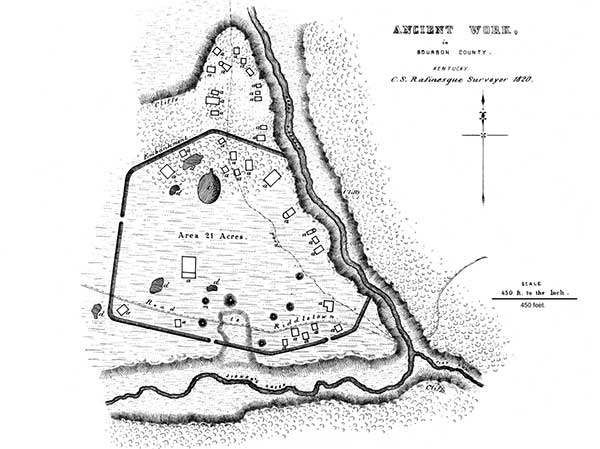
This work, which seems incontestibly of a defensive character, is situated on Stoner's creek, at the mouth of Flat Run, in Bourbon county, Kentucky. The wall throughout is composed of earth, and is slight, not exceeding three or four feet in height. A number of' mounds and excavations occur within the enclosure, together with other remains, consisting of raised outlines, two or three feet broad and one foot high. These are indicated by the letter a, and are denominated "remains of dwellings" by Rafinesque. Twenty of them are found within, and fourteen without the walls; the latter occupying the point of land to the north of the enclosure. The larger one is called "the palace" by our fanciful authority, and is represented to be eighty feet long by seventy-five broad. To the north of "the palace" is an elliptical, hollow area, fifteen feet deep; it is indicated by the letter c. A number of irregular excavations are marked by the letter d. The Lexington road passes through this work.
PLATE XIII. No. 2.27
[From the Surveys and Notes of James McBride.]
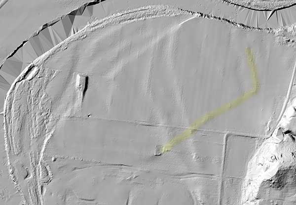
[ Today this site is known as the Colerain Works Archaeologica District. A faint ghost image of the fortification is still visible in Lidar imagery as shown below and highlighted in yellow. GPS: 39.29677889, -84.65113878]
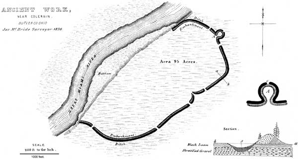
This work is one of the first magnitude; and in many respects bears a close resemblance to the great work on the North fork of Paint creek. (See Plate IX.) It is situated near the village of Coleraine, Hamilton county, Ohio, on the right bank of the Great Miami river, and encloses an area of ninety-five acres. The walls have an average height of nine feet, and have an exterior ditch of proportionate dimensions. The terrace upon which the work is located is thirty feet above the usual stage of water in the river.
The outwork of which A is an enlarged plan, possesses all the features of a bastion and was perhaps designed as such. It could hardly have been intended as a gateway; for, although the ditch is interrupted for a narrow space at c, the embankment is unbroken.
The transverse section of the wall, a b, demonstrates the artificial origin of the work, which it is not probable any one would be disposed to deny. The upheaved gravel upon the exterior side of the wall, wherever it is under cultivation, supports dwarfed and sickly maize; while on the inner side, the grain is luxuriant. This feature and its cause are indicated in the section.
This work, which was undoubtedly defensive, commands a large peninsula, two miles in circumference, formed by a singular bend in the river. About two hundred paces distant from this enclosure, in a southern direction, is the site of old Fort Dunlap, somewhat celebrated in the early history of the Miami valley. It was invested by the notorious Simon Girty, with a force of six hundred Indians, in 1791, without success. Some distance from the fort, and still further to the south, is a hill three hundred feet in altitude, upon the top of which are two mounds, measuring five and ten feet in height, respectively. They are composed of earth and stones, considerably burned.
27. This work is marked C, in the map of a "Section of six miles of the Miami valley," Plate III.
Copyright © 2009 Calvin & Rosanna Hamilton. All rights reserved.