

PLATE XVI.38
High Bank Works, Ross County, Ohio.
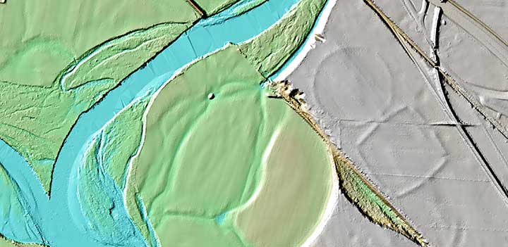
This is a Lidar Image of High Bank Works as it appears today. Due to constant cultivation since the 1800s,
only the main circle and octogon can be seen today. The rest of the site has been destroyed. When this site was surveyed in 1846,
the walls were between 11 and 12 feet high with a base thickness of 50 feet. Today the walls are less than three feet high and are
spread out for more than 100 feet.
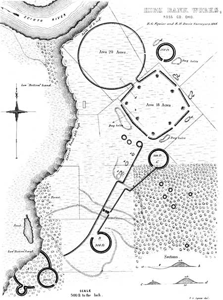 THE beautiful group here represented is situated on the right bank of the Scioto
river, five miles below the town of Chillicothe, near the road from that place to
Jackson. It occurs at a place where the river has cut its way up to the third
terrace, which in consequence here presents a bold bank, rising seventy-five or
eighty feet above the water. This point is generally known as the "High Bank,"
and gives its name to these works. The third terrace here spreads out into a beautiful,
level plain of great extent. The principal work consists of an octagon and
a circle; the former measuring nine hundred and fifty feet, the latter ten hundred and
fifty feet, in diameter. The coincidences, in the dimensions, between this and the
"Hopeton Works," (Plate XVII,) will be at once observed. The octagon is not
strictly regular; although its alternate angles are coincident, and its sides
equal. The circle is a perfect one. In immediate connection with the work are
two small circles, which are shown in the plan, each measuring two hundred and
fifty feet in diameter.
THE beautiful group here represented is situated on the right bank of the Scioto
river, five miles below the town of Chillicothe, near the road from that place to
Jackson. It occurs at a place where the river has cut its way up to the third
terrace, which in consequence here presents a bold bank, rising seventy-five or
eighty feet above the water. This point is generally known as the "High Bank,"
and gives its name to these works. The third terrace here spreads out into a beautiful,
level plain of great extent. The principal work consists of an octagon and
a circle; the former measuring nine hundred and fifty feet, the latter ten hundred and
fifty feet, in diameter. The coincidences, in the dimensions, between this and the
"Hopeton Works," (Plate XVII,) will be at once observed. The octagon is not
strictly regular; although its alternate angles are coincident, and its sides
equal. The circle is a perfect one. In immediate connection with the work are
two small circles, which are shown in the plan, each measuring two hundred and
fifty feet in diameter.
The walls of the octagon are very bold; and, where they have been least subjected to cultivation, are now between eleven and twelve feet in height, by about fifty feet base. The wall of the circle is much less, nowhere measuring over four or five feet in altitude. In all these respects, as in the absence of a ditch and the presence of the two small circles, this work resembles the Hopeton Works already alluded to. There are no mounds, except the small ones covering the gateways of the octagon. About half a mile to the southward, and connected with this work by lines of embankment, much reduced but still traceable, is a small group of works, partially destroyed by the river. A fourth of a mile below this subordinate group, on the bank of the terrace, is a large truncated mound, thirty feet in height. It does not fall within the area exhibited on the map.
At various points around this work are the usual pits or dug holes, some of which are of large size. To the left of the great circle, on the brow of the terrace, is an Indian burial place. The construction of a farm road down the bank disclosed a large quantity of human bones, accompanied by a variety of rude implements. A short distance below this point, on the same bank of the river, is the former site of an Indian town.
A number of small circles occur about a hundred rods distant from the octagon, in the forest land to the south-east. They measure nearly fifty feet in diameter, and the walls are about two feet in height. It has been suggested that they are the remains of structures of some kind, and also that they were the bases of unfinished mounds. There are no indications of entrances or passage ways, a circumstance which favors the latter hypothesis. Similar small circles occur within or in the immediate vicinity of several other large works.
38. Marked J in Map, Plate II.
Copyright © 2009 Calvin & Rosanna Hamilton. All rights reserved.