

PLATE XXVIII.
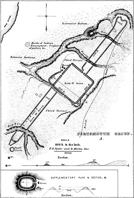
Portsmouth Works—Group A.
[With the exception of the square in the the middle, most of this site has been destroyed.]
THE singular work, a plan of which is here given, occurs on the Kentucky side of the Ohio river, opposite the old mouth of the Scioto, about two miles below the town of Portsmouth. The terrace on which it is situated is elevated some fifty feet above the first bottom, and extends back to the hills, which at this point are at some distance from the river. It is much cut up by ravines, and is quite uneven.
The main body of the work is situated upon a very beautiful level, somewhat ascending to the east. The wings are on equally beautiful levels, except that they are broken at two or three points by ravines.
The principal work is an exact rectangle, eight hundred feet square. The walls are about twelve feet high, by thirty-five or forty feet base, except on the east, where advantage is taken of the rise of ground, so as to elevate them about fifty feet above the centre of the area. This feature is exhibited in the section a b.
The hollow way between the south-eastern wall and the terrace bank beyond seems artificial,—at any rate, it has been modified by art. The gateway on this side is entered by a slightly elevated causeway. At the southern angle is a bastion, probably natural but adapted by art, which commands the hollow way or ditch. The wall at this part is distinctly marked, but not more than three feet high. On the south-western side is a sort of runway, resembling a ditch, which loses itself in a deep gully towards the river. It is undoubtedly wholly or in part artificial. There are no traces of ditches elsewhere about the work. A narrow gateway thirty feet wide opens in the middle of each side, and at the northern and western angles, as represented in the plan.
The most singular features of this structure are its outworks, which consist of parallel walls leading to the north-east and south-west. They are exactly parallel to the sides of the main work, and are each two thousand one hundred feet long. Some measurements make them of unequal lengths; but after a careful calculation of the space occupied by the interrupting ravines, they are found to be very nearly, not exactly, of the same length.
The parallel to the south-west has its outer wall in line with the north-western wall of the main work, and starts at thirty feet distance from the same. It is broken by a deep ravine near its extremity, which is probably four or five hundred feet wide. Crossing the ravine, the walls, traces of which are seen on the declivity, continue to some distance, and then curve on a radius of one hundred feet, leaving a narrow gateway eight feet wide in the centre. Converging walls start from the point of curve, but lose themselves after running three hundred feet, without meeting. Just beyond and a little to the right, on the plain, are two clay mounds, also a small circle one hundred feet in diameter, the walls of which are two feet high.
The parallel to the north-east starts from the centre (nearly) of the main work, and is similar to the one already described, save that it is not terminated by converging walls, and has no mounds beyond. It is interrupted by two ravines, the walls running to their very edges. The left wall of the parallel bends to a right angle as it approaches the main work.
To the left of this parallel, four hundred and fifty feet from a point eight hundred feet distant from the main work, on a high peninsula or headland, is a singular redoubt, an enlarged view of which is given in the supplementary plan N. To the left of it is the bank of the second bottom, fifty feet high, and very steep. To the right is the hollow of a small stream with steep banks. The embankment of this work is heavy, and the ditch deep and wide, and interior to the wall. From the bottom of the ditch to the top of the wall, is perhaps twelve or fifteen feet. The enclosed oval area is only sixty feet wide by one hundred and ten long. It has a gateway to the north-east ten feet wide,—outside of which, in the deep forest, is the grave of one of the first settlers. The object of this enclosure it is difficult to divine. If a place of burial, as has been suggested, properly conducted excavations would disclose the fact.
A light wall of some hundred paces in extent runs from the left hand entrance of the main work, along the verge of a declivity terminating at the western angle. On this side are also three mounds, each about six feet high,&mdsah;formerly much higher, having been greatly reduced by the plough. From the western angle a deep gully runs off to the river; it has been mistaken by some for a covered way. The entire main work, the greater part of the lower parallel, and a portion of the upper one, are now in open cultivated grounds. The walls of the main work are so steep as to preclude cultivation, and now form the fence lines of the area, which is fifteen acres. The area of the parallels is ten acres each;—total, thirty-five acres.
Between this work and the river are traces of a modern Indian encampment or town,—shells, burned stones, fragments of rude pottery, etc., also some graves. This was a favorite spot with the Indians, for various reasons, one of which is its proximity to a noted saline spring or deer lick, known as "McArthur's Lick." From the size of the walls, their position, and other circumstances, it has been supposed that this was a fortified place. If palisaded, it Would certainly be impregnable to any savage attack. If designed as a sacred place, its sloping area would be most fit for the observance of sacrifices or ceremonies.
What may have been the purpose of the mysterious parallels, is more than we, at this period, can venture to say.
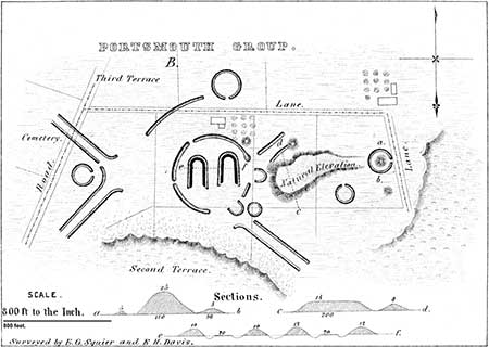
PLATE XXVIII.
Portsmouth Works—Group B.
THIS group also occupies the third terrace, and, though not so imposing in magnitude as the one just described, seems to be the grand centre from which the parallel lines, characterizing this series of works, radiate. Its details are intricate, and can only be understood by the aid of the plan. The two crescent or horse-shoe-shaped walls constitute the first striking feature which presents itself. They are both of about the same size and shape, measuring eighty feet in length by seventy in breadth. The earth around them appears to have been considerably excavated. Enclosing these in part is a circular wall now about five feet high. The elevation to the right appears to be natural, although evidently much modified by art. It is eighteen feet high at the end next the principal division of the work, but gradually subsides into a low ridge towards the enclosed mound a b. A full view of the entire group may be had from its summit. The mound just mentioned is twenty-eight feet high, by one hundred and ten base; it is truncated and surrounded by a low circumvallation. There are several small circles, measuring from one hundred and fifty to two hundred and fifty feet in diameter; also a few mounds, in the positions indicated in the plan.No one, after examining its details, would be apt to ascribe a military origin to this group. The most reasonable conjecture respecting it is, that it was in some way connected with the superstitions of the builders; in what manner, of course, it is impossible to determine. A thorough examination of the mounds might throw some light on the question. At any rate, it is entirely unique in many of its features, and furnishes an interesting study for the antiquary.
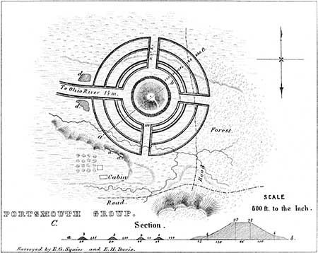
PLATE XXVIII.
Portsmouth Works—Group C.
THIS group is on the Kentucky shore, and principally occupies the third terrace, or high level at the base of the hills bordering the valley. The ground is here considerably broken. The northern portion of the work is somewhat lower than the remainder, and a small brook cuts through the outer wall on the south. This work is in many respects novel, and for this reason, as well as from the connection in which it is found, is entitled to an attention not otherwise merited; for no person looking merely for what is striking from position, or imposing from magnitude, would be apt to pay it a second visit. It consists of four concentric circles, placed at irregular intervals in respect to each other, and cut at right angles by four broad avenues, which conform in bearing very nearly to the cardinal points. A large mound is placed in the centre; it is truncated and terraced, and has a graded way leading to its summit. A reference to the plan and sections will exhibit in one view the dimensions and general aspect of the work, obviating the necessity of a detailed description.The mound in the centre, at first glance, would be taken for a natural elevation; and it is possible that it is a detached spur of a hill, modified and perhaps enlarged by art. A hillock in such a position is, however, a circumstance of very rare occurrence. From the level summit of this mound, a complete view of every part of the surrounding work is commanded. Were it not for the obstructing forests, it is believed the eye might obtain, from this position, a view of the river and intermediate plain, as also of the works beyond, and several miles distant. .On the supposition that this work was in some way connected with the religious rites and ceremonies of the builders, this mound must have afforded a most conspicuous place for their observance and celebration. And it is easy, while standing on its summit, to people it with the strange priesthood of ancient superstition, and fill its avenues and line its walls with the thronging devotees of a mysterious worship. Whatever may have been the divinity of their belief, order, symmetry, and design were among his attributes; if, as appears most likely, the works that most strongly exhibit these features were dedicated to religious purposes, and were symbolical in their design.
About one mile to the west of this work are a number of mounds, some of considerable size, and also a small circular work, D, of exquisite symmetry and proportion. It consists of an embankment of earth five feet high by thirty feet base, with an interior ditch twenty-five feet across by six feet deep, enclosing an area ninety feet in diameter, in the centre of which rises a mound eight feet high by forty feet base. A narrow gateway through the parapet, and a causeway over the ditch, lead to the enclosed mound.
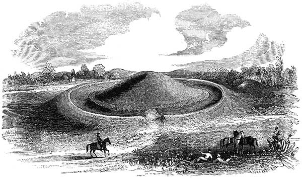
Figure 19. Circle and mound, Greenup County, Kentucky.
The above view, taken on the spot, will illustrate the appearance of this class of works. Nothing can exceed their regularity and beauty, when clothed with turf or covered with forest trees.
Copyright © 2009 Calvin & Rosanna Hamilton. All rights reserved.