PLATE XXIX. No. 1.
Ancient Works, Montgomery County, Ohio.63
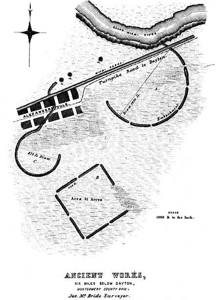
THESE works are situated on the east bank of the Great Miami river, six miles below Dayton, Montgomery county, Ohio. They are built upon the second bottom or terrace,which is here nearly a mile broad, and elevated about twenty feet above the river. The Plan of the group coincides very nearly with that of some of the more regular works of the Scioto valley. (See Plates XX and XXI.) It seems never to have been completed, at any rate, the various parts were never connected. A portion of the great circle A has been washed away by the river, which here encroaches upon the second terrace. The diameter of this circle is one hundred feet greater than that of the corresponding large circle of the Scioto works; and the same proportionate increase in size is to be observed in the square and lower circle. The embankments are now between five and six feet high, and have a base fifty feet wide. They are composed of a tough, yellow clay, which is found to be superimposed on the loam of the original level. It must have been brought from a distance, as there are no excavations perceptible in the vicinity. The embankrnents, as in the case of several other works which have been noticed, appear to have been some time or other subjected to the action of fire. They are unaccompanied by a ditch.
The Miami canal extends through these works, and the little town of Alexandersville is laid out over a portion of the smaller circle. The clay composing the embankments is now much used in the manufacture of bricks, and but a little time will elapse before the work will be entirely obliterated.
We can only regard this structure as kindred in its purposes to those above alluded to in the Scioto valley, and associate it with the superstitious of the builders. It tends to confirm the impression produced by the other works, that some significance attaches to the combination of the two circles and the square.
PLATE XXIX. No. 2.
ANCIENT WORKS, SCIOTO COUNTY, OHIO.64
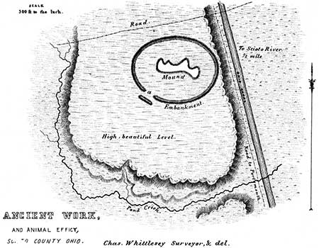
THIS singular work is situated five miles north of Portsmouth, Scioto county, Ohio, on the west bank of the Scioto river. It is not a true ellipse, but approaches very near it. Its longest axis is four hundred and eighty feet, its conjugate diameter four hundred and seven feet. It is built upon a high and beautiful level, elevated some sixty or seventy feet above the Scioto river, which flows about half a mile to the eastward. The embankment is unaccompanied by a ditch, and is about three feet in height, by thirty feet base. It has, as shown in the plan, a single gateway, ninety feet wide, opening to the south-east, which is covered by a long exterior mound, of about the same height with the embankment of the enclosure.
Within this enclosure is a large irregular mound, which, from its resemblance to the animal-shaped mounds of Wisconsin, of which notice will be taken in another place, constitutes by far the most interesting feature of the work. It is of the form and relative size indicated in the plan, and is composed of loose broken sandstone and earth, based upon dislocated and broken sand-rock. It is from one to eight feet high, being lowest at the eastern end or head, and at the projecting points. It is probably of the same design with those of Wisconsin, already alluded to, which occur in great numbers and in long and apparently dependent ranges. None of those, however, so far as known, are found enclosed after the manner of the one here presented. (See "Remains of the North-West.") No explanation of the probable design of this work will be attempted here: it is impossible, however, to disconnect it from the superstitions of the ancient people. An interesting fact is communicated by F. Cleveland, Esq., of Portsmouth, who assisted Mr. Whittlesey in making the survey of this work, and who was engineer on the Ohio canal when it was in progress; viz. that the workmen engaged in excavating found large quantities of mica, in sheets, in the immediate vicinity of this enclosure. This mineral is found in great abundance in the mounds, and in the neighborhood of these ancient works.
PLATE XXIX. No. 3.
ANCIENT WORKS, FRANKLIN COUNTY, OHIO.65
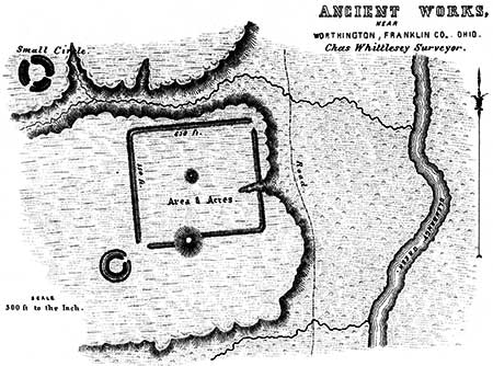
THIS work occurs on the banks of Olentangy creek, a tributary of the Scioto river, about one mile west of the town of Worthington, Franklin county, Ohio. The plateau upon the edge of which it is situated is elevated about fifty feet above the bottoms of the Olentangy, and consists of a clayey soil resting on the black shale formation of Ohio. The work is rectangular in form; its sides correspond very nearly with the cardinal points, (varying but five degrees,) and measure six hundred and thirty, and five hundred and fifty feet respectively. The walls are unaccompanied by a ditch, and are very slight, though distinctly traceable. In the line of the southern wall is a large truncated mound, C, twenty feet in height, and measuring one hundred and ninety-two feet in diameter at the base, and seventy-six feet in diameter at the summit. It is covered with large trees. The wall that leads from this mound to the left, is placed a little further outwards than that leading to the right. The mound D, in the centre of the enclosure, is small and low. Near the south-western corner of the work is a small circle, with an interior ditch and single entrance; it is one hundred and twenty feet in diameter. Some distance to the north-west of the enclosure, and on the opposite side of a deep ravine, is another small circle, one hundred and forty feet in diameter, with three entrances.
63. From the Survey and Notes of JAMES MCBRIDE, Esq.
64. From the Survey and Notes of CHARLES WHITTLESEY, Esq.
65. From the Plan and Notes of CHARLES WHITTLESEY, Esq.


