

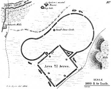
PLATE XXI. No. 1.44 (Known as the Baum Earthworks)
 |
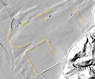 |
| Even though this site has been plowed for over 100 years, yet a faint outline can still be seen in the Lidar image on the right. The visible pieces are highlighted with a faint yellow color. | |
THIS work is situated on the right bank of Paint creek, fourteen miles distant
from Chillicothe. It is but another combination of the figures composing the
work belonging to this series, just described; from which, in structure, it differs in
no material respect, except that the walls are higher and heavier. It is one of the
best preserved works in the valley; the only portion which is much injured being
at that part of the great circle next the hill, where the flow of water has obliterated
the wall for some distance. The gateways of the square are considerably wider
than those of the other works,—being nearly seventy feet across. A large, square,
truncated mound occurs at some distance to the north of this work. It is one
hundred and twenty feet broad at the base, has an area fifty feet square on the
top, and is fifteen feet high. Quantities of coarse, broken pottery are found on
and around it. A deep pit, or dug hole, is near, denoting the spot whence the
earth composing the mound was taken.
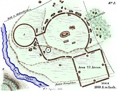
PLATE XXI. No. 2.45
[Today this is known as the Seip Group]
FIVE miles above the work last described, at "the crossings of Paint creek," and on the opposite bank of the stream, occurs an equally singular and interesting work, situated upon the estate of JOHN WOODBRIDGE, Esq., of Chillicothe. The ground is here considerably broken, yet the work preserves its regularity through-out, although evidently constructed with some regard to the nature of the position. The square occupies the second terrace; while the main body of the work is placed upon the third, as shown in the plan.
Within the larger circle, and not far from its centre, is a large elliptical mound, two hundred and forty feet long by one hundred and sixty broad, and thirty in height. It is considerably larger than any other single mound in the valley, and covers a little more than two thirds of an acre. It seems to be composed, at least towards the surface, of stones and pebbles,—a feature peculiar to a certain class of mounds, of a highly interesting character. It is surrounded by a low, indistinct embankment, the space between which and the mound seems to have been raised by the wasting of the latter. Perhaps this was a low terrace. To the right of this fine mound is a group of three others in combination, as shown in the plan at c. There are several other small mounds in and around the work. Several very large and beautiful ones, composed entirely of clay, occur about one fourth of a mile distant, in the direction indicated in the plan.
The entire work is surrounded by deep pits or excavations, usually called "wells," from which the materials for the mounds and embankments were procured. So numerous are these, and such serious obstacles are the mounds and embankments to cultivation, that a deduction of several acres is allowed to the tenant in consequence, by the lease of the estate upon which they occur. The small circle at a is two hundred and fifty feet in diameter. It has been so much reduced by the plough as to be traced with difficulty.46
Although the square enclosure connected with this work is situated on the second terrace, a portion of it, at periods of great freshets, is invaded by the water, which passes through a shallow thoroughfare indicated on the map. This singular circumstance is easily accounted for. The creek in its course strikes the base of a high hill at B, composed of shale, which readily undermines, occasioning great slips or slides. These fill the channel of the creek, damming it up and forcing it out of its usual course. It was probably at the period of one of these slides, that the creek, in its reaction on the opposite shore, broke through the embankment and formed the thoroughfare, or dry channel, above mentioned. The remark, therefore, that the earthworks of the West never occur upon the first, or latest-formed terrace, and are always above high-water mark, is not at all invalidated by this circumstance.
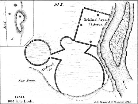
PLATE XXI. No. 3.47
[This site is destroyed.]
THIS work very closely resembles the one last described. It is situated on the Scioto river, about one mile south of the town of Chillicothe. Near it was erected the first civilized habitation in the valley, and the ground has been in cultivation for more than forty years. As a consequence, the walls are much reduced, although distinctly traceable at this time. A portion of the square has been destroyed by the invasion of the river. The large circle has also been encroached upon at some period, if indeed it was ever completed. It extends to the terrace bank, which is here twelve or fifteen feet high. The low bottom, at the base of the terrace, was evidently at one time the bed of Paint creek, which has since changed its channel, and now runs more than a mile to the south-west, entering the river three or four miles below this point. If the encroachment upon the work was made by this stream, the fact would certainly assign to it a very high antiquity. There are no mounds in the immediate vicinity of this work, although there are several in the direction indicated in the plan, about one fourth of a mile distant, upon the corresponding terrace A. There is also an extensive and intricate series of works in the direction of Chillicothe, a portion of which once occupied the site of the city.48
One of the mounds at A is placed upon a singular ridge, some forty or fifty feet in height, which has resisted the encroachments of the water, and which itself somewhat resembles an artificial structure. This elevation commands the entire plain. There are several mounds at its base, one of which is of considerable size. All have been excavated: the larger one was found to be sepulchral in its character; the others are anomalous.
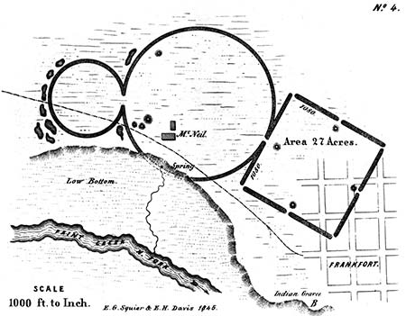
PLATE XXI. No. 4.
[With the exception of one mound, called the Henneberger Mound, this site has been destroyed.]
THIS work is sixteen miles distant from the one last described, and is situated on the left bank of the North fork of Paint creek. A portion of it is included in the town limits of Frankfort, better known as "Oldtown," or "Old Chillicothe."49
The combination of the great circle and the square, in this work, is identical with that which exists in the celebrated Circleville work,—which work, it may be observed, is no more remarkable than numbers of others, and owes its celebrity entirely to the fact, that it has been several times described with some minuteness.
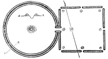 |
| Figure 10. |
The walls of the rectangular portion of the Frankfort work, where not obliterated by the improvements of the town, are still several feet high. They were, within the recollection of many people, much higher. They are composed of clay (while the embankment of the circle is composed of gravel and loam), which, as in the case of the square work described, Plate X, appears to have been very much burned.
The isolated mound near the upper boundary of the circle is composed entirely of clay, and is twelve feet high; the others are of gravel, the largest being no less than twenty feet in altitude. Various dug holes or pits, from which the material for the embankments and mounds was evidently taken, are indicated in the plan. Some of them are, at this time, fifteen or twenty feet deep. The subsoil at this locality, as shown by excavation, is clay. If there was no design, therefore, in constructing the walls of the square of that material, it follows that it was built last, and after the loam and gravel had been removed from the pits.
A portion of the large circle has been encroached upon and destroyed by the creek, which has since receded something over a fifth of a mile, leaving a low rich bottom intervening.
Such are the predominant features of this remarkable series of works. As already remarked, the coincidences observable between them could not have been the result of accident, and it is very manifest that they were erected for common purposes. What those purposes were, the reader must judge. Without entering into an argument upon the subject, we may content ourselves with the simple expression of opinion, that they were in some manner connected with the superstitions of the builders.
There is one deduction to be drawn from the fact, that the figures entering into these works are of uniform dimensions, which is of considerable importance in its bearing upon the state of knowledge among the people who erected, them. It is that the builders possessed a standard of measurement, and had some means of determining angles. The most skilful engineer of the day would find it difficult, without the aid of instruments, to lay down an accurate square of the great dimensions of those above represented, measuring as they do more than four fifths of a mile in circumference. It would not, it is true, be impossible to construct circles of considerable size, without instruments; the difficulty of doing so, when we come to the construction of works five thousand four hundred feet, or over a mile in circumference, is nevertheless apparent. But we not only find accurate squares and perfect circles, but also, as we have seen, octagons of great dimensions. Other evidences tending to sustain the above conclusions will be adduced in the progress of this work.
44. Indicated by the letter B, in Map 1, Plate III. This and the succeeding work are represented by Mr. Atwater in the Archaeologia Americana. vol, i. p. 146; with what fidelity, an inspection of the respective plans will show.
45. Indicated by the letter A, in Map 2, Plate III.
46. Mr. Atwater (Archaeologia Americana, vol. i. p. 143) describes the small mound at e, as composed "entirely of red ochre, which answers very well as a paint!" Its present composition is a clayey loam. It has been examined and found to contain an altar.
47. This work is designated by the letter H on the Map, already several times referred to, Plate II.
48. Their general character is indicated in Map, Plate II.
49. The site of the town of Frankfort was formerly that of a famous Shawnee town. The burial place of the Indian town is shown in the plan; from it numerous relics are obtained,—gun-barrels, copper kettles, silver crosses and brooches, and many other implements and ornaments which, in accordance with aboriginal custom, were buried with the dead. Some of them, from being found in close proximity to the work above described, have erroneously been supposed to appertain to the race of the mound-builders.
50. Archaeologia Americana, vol, i. p. 142.
Copyright © 2009 Calvin & Rosanna Hamilton. All rights reserved.