

PLATE XXXI.
Graded Way, Near Piketon, Pike County, Ohio.
[All that remains of this site are a few mounds now located at Mound cemetery. The Graded way has been destroyed and is discussed in the article Piketon's Graded Way Was Graded Away.]
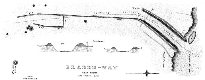
THERE is a singular class of earthworks, occurring at various points at the West, which seem better to come up to the utilitarian standard of our day than any other, and the purposes of which to the popular mind, if not to that of the antiquarian, seem very clear. These are the graded ways, ascending sometimes from one terrace to another, and occasionally descending towards the banks of rivers or water-courses. The one already described, in connection with the works at Marietta, is of the latter description; as is also that at Piqua, Ohio, described by Maj. LONG.66 One of the former character occurs near Richmondale, Ross county, Ohio; and another, and the most remarkable one, about one mile below Piketon, Pike county, in the same State. A plan and view of the latter is herewith presented.
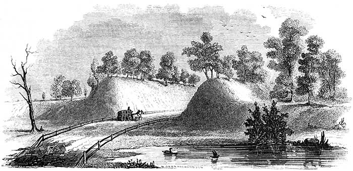
Figure 20. View of Graded Way Near Piketon, Ohio.
It consists of a graded ascent from the second to the third terrace, the level of which is here seventeen feet above that of the former. The way is ten hundred and eighty feet long, by two hundred and fifteen feet wide at one extremity, and two hundred and three feet wide at the other, measured between the bases of the banks. The earth is thrown outward on either hand, forming embankments varying upon the outer sides from five to eleven feet in height; yet it appears that much more earth has been excavated than enters into these walls. At the lower extremity of the grade, the walls upon the interior sides measure no less than twenty-two feet in perpendicular height. The easy ascent here afforded has been rendered available in the construction of the Chillicothe and Portsmouth turnpike, which passes through it. The walls are covered with trees and bushes, and resemble parallel natural hills, and probably would be regarded as such by the superficial observer. Indeed, hundreds pass along without suspecting that they are in the midst of one of the most interesting monuments which the country affords, and one which bears a marked resemblance to some of those works which are described to us in connection with the causeways and aqueducts of Mexico.
From the end of the right-hand wall, upon the third terrace, extends a low line of embankment, (now much obliterated by the construction of the turnpike,) two thousand five hundred and eighty feet long, leading towards a group of mounds, as shown in the plan. At the distance of fifteen hundred feet from the grade, a wall starts off at right angles, for the distance of two hundred and twelve feet, when it assumes a course parallel to the principal line for four hundred and twenty feet, and then curves inwardly, terminating near a group consisting of one large and three small mounds. A ground plan of the latter is elsewhere given. This group of mounds is now enclosed, and constitutes the cemetery of the neighborhood. Forty rods to the right of this group, is a large mound thirty feet in height. Several small mounds occur upon the adjacent plain, though no enclosures of magnitude are found nearer than five miles lower down, on the river.
The left-hand wall of the grade as we descend seems continued down upon the second terrace for some distance, terminating near a low spot of ground, usually containing water. Similar depressions are observed in the ancient beds of streams. It has been suggested that the Scioto river once flowed along the base of the terrace at this point, and that the way led down to it. Without expressing an opinion upon the probability of this conjecture, it is sufficient to observe that the river now flows more than half a mile to the left, and that two terraces, each twenty feet in height, intervene between the present and the supposed ancient level of the stream. To assent to the suggestion, would be to admit an almost immeasurable antiquity to the structure under consideration.
It is, of course, useless to speculate upon the probable purpose of this work. At first glance, it seems obvious; namely, that it was constructed simply to facilitate the ascent from one terrace to another. But the long line of embankment extending from it, and the manifest connection which exists between it and the mounds upon the plain, unsettle this conclusion. After all, we are obliged to leave this interesting work with the single remark, already several times made in respect to others equally interesting and inexplicable, that future investigations, carefully conducted, may solve alike the problem of their purposes and of their origin.67
A singular work of art occurs on the top of a high hill, standing in the rear of the town of Piketon, and overlooking it, which it may not be out of place to mention here. It consists of a perfectly circular excavation, thirty feet in diameter, and twelve feet deep, terminating in a point at the bottom. It contains water for the greater part of the year. A slight and regular wall is thrown up around its edge. A full and very distinct view of the graded way just described is commanded from this point.
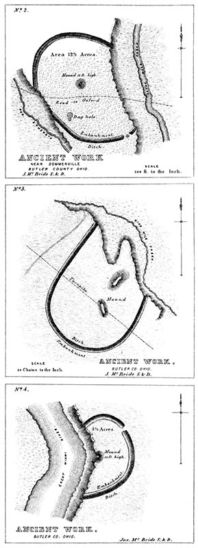
PLATE XXXI. Nos. 2, 3, AND 4.
THE works here presented possess few characteristics of works of defence, and yet have little of the regularity, and but few of the features, which distinguish the sacred enclosures.NUMBER 2 is situated near Sommerville, Butler county, Ohio, on S. 3 and 10, T. 5, R. 2, E. M. It occupies the second terrace between Pleasant run and Seven Mile creek, and seems to have been encroached upon by both these streams. This terrace is about twenty-five feet higher than the first terrace, and is bounded by steep banks. The wall of the work is about four feet high, the ditch of proportionate depth. Near the centre is an exceedingly regular mound, one hundred feet in diameter at the base, and thirteen feet in altitude. It is now covered with a line growth of maple-trees. At the north-east corner of the work, in the embankment, there is a quantity of stones placed with some degree of regularity,—probably originally constituting a sort of wall. At the opposite extremity of the work is a dug hole or "well."
NUMBER 3 is situated nine miles north of the town of Hamilton, Butler county, Ohio, on a rich alluvial bottom, between Seven Mile and Nine Mile creeks, the latter of which seems to have encroached upon the work. The large oblong mound in the centre was partially excavated in constructing the Hamilton and Eaton turnpike. A quantity of bones were discovered; but nothing is known of the position in which they were found.
NUMBER 4 is situated on the east bank of the Great Miami river, four miles below the town of Hamilton, Butler county, Ohio, and is indicated by the letter D, in the map of a section of the Miami valley. Probably not more than half the original work now exists, the remainder having been destroyed by the encroachments of the river. The wall and ditch are slight; the former not exceeding three feet in height, and the latter two feet in depth. At the bank of the river, however, the original depth of the ditch, as also the amount of the vegetable and other matter with. which it is filled up, are distinctly visible. The ditch, which had been sunk into the gravel, was originally five feet eight inches in depth; the accumulation since its abandonment has been, therefore, three feet eight inches. Allowing the wall to have subsided to an equal extent, its original height from the bottom of the trench must have been upwards of twelve feet.
The rapidity with which the river encroaches upon its banks at this point may be inferred from the fact, that twenty years previous to the time of the survey of this work by Mr. McBride, in 1836, the river flowed not far from three hundred feet to the left of the central mound, which since that time has entirely disappeared. About thirty feet below this mound was found, some years ago, a number of flat stones set on edge, forming a kind of coffin, in which was a human skeleton, accompanied by a large marine shell and some rude implements. About a fourth of a mile below this work, appears to have been a general cemetery. The graves are indicated by small regular elevations.68 The three works last described are laid down from the surveys of Mr. MCBRIDE, from whose notes the above facts are principally derived.
66. "It consists of a ditch dug down to the edge of the river, the earth from which has been thrown up principally upon the lower, or down-river side. The breadth between the parapets is much greater near the water than at any other point; so that it might have been used for the purpose of affording a safe passage to the river, or as a sort of harbor in which canoes may have been drawn up, or both, This water-way resembles that found at Marietta, though smaller."—Long's Second Expedition, vol i. P 60.
67. The reader is requested to compare the plan of this work given by Mr. ATWATER in the Archaeologia. Americana, with the one here presented.
68. Previous to the entire destruction of this mound, and at the time when about one half of it remained, it was examined by Mr. McBride, from whose original notes the following observations respecting it are taken:
"The mound was composed of rich surface mould, evidently scooped up from the surface; scattered through which were pebbles and some stones of considerable size, all of which had been burned. Upon excavation, we found a skeleton with its head to the east, resting upon the original surface of the ground, immediately under the apex of the mounds Some distance above this was a layer of ashes of considerable extent, and about four inches thick. The skeleton was of ordinary size; the skull was crushed, and all the bones in extreme decay. Near the surface were other skeletons. The inhabitants of the neighborhood tell of a copper band with strange devices, found around the brow of a skeleton in this mound; and also of a well carved representation of a tortoise of the same metal, twelve or fourteen inches in length, found with another skeleton."
Copyright © 2010 Calvin & Rosanna Hamilton. All rights reserved.