

PLATE XXXII.
UPON this plate are placed a number of small works, and groups of works, arranged however with no view to any relationship, but as best served the purposes of the engraver.
[This site cannot be located with Lidar Imagery and is presumed to be destroyed.]
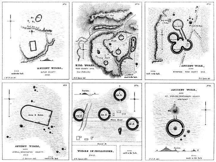
NUMBER 1 is a group of small works situated on a branch of Mill creek, near
the south-east corner of Butler county, Ohio, on S. 14, T. 3, R. 2, M. R. The
rectangular work is two hundred and twenty feet long, by one hundred and twenty
feet broad. The walls are now about five feet high, and are unaccompanied by a
ditch. There were standing upon the embankment, in 1842, a red-oak tree three
and a half feet in diameter, and a white-oak tree three feet in diameter. Twenty
rods north of this work is a truncated mound ten feet high; and a short distance
beyond it, rises a steep bank, fifty feet high, ascending which we come to elevated
ground. Here are the remains of another small elliptical work, and some mounds.
Upon the brow of the bank, at a, is a pile of stones much burned, which is known
in the vicinity as "the furnace." Immediately below, at the foot of the bank, is a
copious spring. The survey of this group was made by Mr. MCBR1DE.
[This site cannot be located with Lidar Imagery and is presumed to be destroyed.]
NUMBER 2 is situated near the town of Lowell, Washington county, Ohio, and
consists of a slight embankment of earth, of exceedingly regular outline. Little
can be said of it, except that it is accompanied by eleven mounds; all of which are,
however, exterior to the walls.
[This site cannot be located with Lidar Imagery and is presumed to be destroyed.]
NUMBER 3 is a group of small works, occupying the high lands on the east side
of the Scioto river, opposite Chillicothe. They are indicated by the letter L, in
the map of a section of the Scioto valley (Plate II). They are introduced on a
very small scale, so as to exhibit the dependence which seems to exist between
them. Of course the relative size of the circles and mounds is considerably
exaggerated. The mound numbered 1 occupies the most conspicuous point in
the valley; and from it is afforded the most extended view that can be obtained
in that entire region. Whether this fact can be taken to establish its design
as a beacon or observatory, it is not presumed to say. The mound numbered
2 is one of the finest known. It is elliptical, one hundred and sixty
feet long, sixty broad, and fifteen high. It has never been investigated. The
remaining mounds, 3, 4, 5, and 6, are all of large size. A fine view of the extensive
ancient works in the vicinity of Chillicothe must have been afforded from these
elevated plains.
[This site cannot be located with Lidar Imagery and is presumed to be destroyed.]
NUMBER 4.—These works are included within the corporation limits of Chillicothe.
They are already much obliterated, and will soon be no longer traceable.
They consist of a series of small circles, of uniform size, each two hundred and
fifty feet in diameter. More extensive works formerly existed in connection with
them, but have now entirely disappeared. The mound represented in the plan is
seventeen feet in height, and has what seems to be a graded ascent from the south.
It has been excavated, and will be noticed at length elsewhere in this volume. The
circles, it will be observed, appear to be disposed with some degree of regularity
in respect to each other. The gateways of three of them open towards the east,
that of the remaining one towards the south.
NUMBER 5.—This unique little work is situated in the valley of Paint creek, about one mile west of the village of Bainbridge, Ross county, Ohio, on the turnpike leading from Chillicothe to Cincinnati. Its character can only be understood from the plan. It affords but one of the thousand various combinations which the circular structures of the West assume. It can, of course, be regarded only as connected with the superstitions of the builders, for the reason that it could answer no good purpose for protection, nor subserve any of the useful purposes for which enclosures are required, such as the limits of fields and possessions, or the boundaries of villages.
NUMBER 6.—This work is situated near Mount Sterling, Montgomery county, Kentucky; and consists of a large truncated mound, twenty-five feet in height, flanked on the north and west by narrow grades or slopes. It is connected with a circular work, three hundred and fifty feet in diameter, by an elevated way or terrace, one hundred feet long. The circle has a small mound in its centre, and a gateway opening to the east. Three small mounds occur in close connection with it. The plan is from the RAFINESQUE MSS.
Lest these comparatively little works should appear insignificant, from the small scale on which they are presented, it may be well enough to remark, that the circle formed by the stones composing the great temple of Stonehenge is but a little more than one hundred feet in diameter, and that most of the circular earth and stone structures of the British islands are considerably less in size than those here presented.
Copyright © 2010 Calvin & Rosanna Hamilton. All rights reserved.