

PLATE XXXIII. No. 1.69
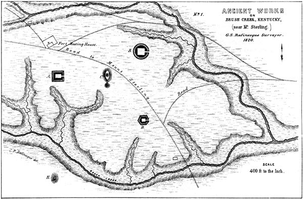
THIS group of ancient works is situated on the west side of Brush creek, six miles south-east of Mount Sterling, Montgomery county, Kentucky. The work indicated by the letter A is one hundred feet square, and is composed of a slight embankment, with an interior ditch. There is an entrance from the east. The elliptical mound C is about two hundred yards distant from A, towards the east. It is nine feet high, two hundred and seventy feet in circumference, truncated, and surmounted by a smaller conical mound. Another small mound is connected with it, as shown in the plan. B is a circular work, five hundred and ten feet in circumference, with a ditch interior to the wall, and a gateway opening towards the east. The unexcavated ground in the interior is square in form, exhibiting an entire identity in this feature with various works in Ohio. (See Plates XXII, XXIV.) D is a hexagonal enclosure; whole circumference three hundred feet, each side fifty feet, with a gateway at the eastern corner. On the opposite side of Brush creek is a large elliptical mound, E. This group occupies a broad, elevated plain. Numerous other works occur in the same county.
PLATE XXXIII. No. 2.70
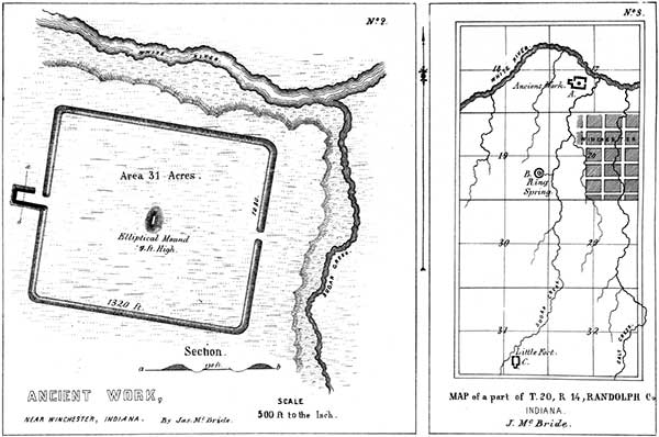 THE character of this work, which is situated in Randolph County, Indiana, is
sufficiently well exhibited by the plan. In the Same vicinity are other works of an
interesting character, the relative positions of which are shown in the sectional
map. The work of which the enlarged plan is here given is indicated by the letter
A on the map. A precisely analogous work, of smaller size, is situated on Sugar
creek at C. At B is a copious spring, surrounded by an embankment.
THE character of this work, which is situated in Randolph County, Indiana, is
sufficiently well exhibited by the plan. In the Same vicinity are other works of an
interesting character, the relative positions of which are shown in the sectional
map. The work of which the enlarged plan is here given is indicated by the letter
A on the map. A precisely analogous work, of smaller size, is situated on Sugar
creek at C. At B is a copious spring, surrounded by an embankment.
69. From the Rafinesque MSS.
70. From the Survey of JAMES MCBRIDE.
Copyright © 2010 Calvin & Rosanna Hamilton. All rights reserved.