

PLATE XXV.  Open in Google Earth
The Newark Works, Licking County, Ohio.55
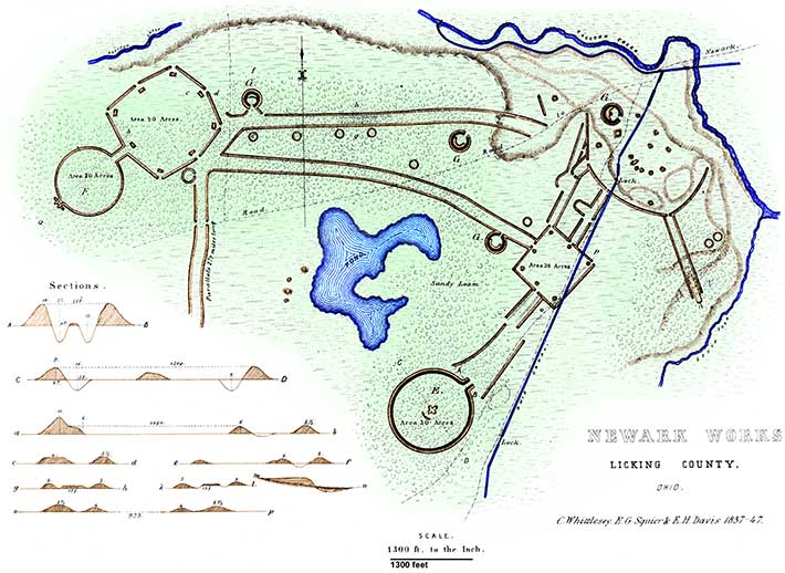
THE very extensive and complicated series of works here presented occur at the junction of the South and Raccoon forks of Licking river, one mile west of the town of Newark, Licking county, Ohio. Like those at Marietta, the works in question occupy a high fertile plain. This plain is here of great extent, and elevated from thirty to fifty feet above the alluvions bordering the streams: it is for the most part level, but in places broken and undulating.
These works are so complicated, that it is impossible to give anything like a comprehensible description of them. The plan, with the illustrative supplementary plans and sections, will furnish a better conception, as a whole and in detail, than could be afforded in any other way. It will be the object of the text to supply such information as cannot be obtained from the plan.
The group covers an extent of about two miles square, and consists, as will be observed, of three grand divisions, connected by parallels and works of a minor character. The walls of the parallels, and of the irregular portions of the works generally, as well as of the small circles, (of which there are a considerable number,) are very slight; for the most part not exceeding four feet in height. The embankments of the principal, or regular portions of the works, are much heavier. Those of the larger circular work, E, are about twelve feet in perpendicular height by fifty feet base, and have an interior ditch seven feet deep by thirty-five wide. At the gateway or entrance, the walls are much higher than at any other point, being not less than sixteen feet in altitude, with a ditch thirteen feet deep, giving an absolute height of about thirty feet from the bottom of the ditch to the top of the embankment. The wall of the lesser circle, F, is six feet in height, and is unaccompanied by a ditch. The walls of the octagonal, as well as of the square work, are but five and a half feet high, and are also destitute of ditches, either exterior or interior.
 |
| Figure 12. |
 |
| Figure 13. A Gateway of Octagon, Looking Inward. |
 |
| Figure 14. |
 |
| Figure 15. |
 |
| Figure 16. View of "Observatory" From the Interior. |
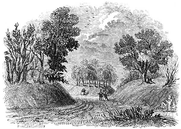
From the octagon lead off three lines of parallel walls: those extending towards the south have been traced for nearly two miles, and finally lose themselves in the plain; the remaining parallels terminate as shown in the plan. They are upwards of a mile in length. The walls composing these singular lines are placed, about two hundred feet apart, and are parallel throughout. A singular feature occurs in the northern one, which is exhibited by the transverse section g h. For the space of a quarter of a mile, advantage is taken of a slight natural ridge to construct between the walls a broad embankment, something higher than the parallels themselves. It is broad enough to permit fifty persons to walk abreast. A similar peculiarity is observed in the short parallel leading from the square enclosure towards the great circle E, and is exhibited by the section i l. A feature somewhat analogous occurs within the parallels extending from the irregular works on the extreme right of the plan. This parallel is carried down the bank of the third terrace, which is here fifteen or twenty feet high. Within the lines, the bank is cut down, and regularly graded to an easy ascent. The pathway or road, for a portion of its extent upon the alluvions, is elevated above the walls, as shown in longitudinal section m n. A similar grade is constructed at the extremity of the northern parallel, where the natural bank is much higher than at any other point. Here the bank is excavated inwardly, for upwards of one hundred and fifty feet; and a portion of the earth is appropriated to form an elevated way over the low swampy ground immediately at the foot of the terrace. These excavations constitute quite imposing features, when viewed on the spot, but are hardly distinguishable upon the plan.
A number of small circles are found connected with the works, and are chiefly embraced in the area between the two principal parallels. They are about eighty feet in diameter, without gateways opening into them; and it has been suggested that they probably mark the sites of ancient circular dwellings. The circles indicated by the letter G are of much larger dimensions, and are characterized by ditches interior to their walls. They each have a diameter of about two hundred feet, and have elevated embankments constructed interior to the ditch, as seen in the plan. This peculiarity has been already remarked, in some of the works of the Scioto valley.
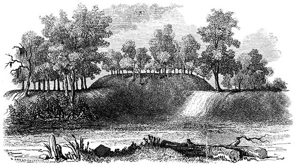
Upon the lower terraces, towards the point of junction between the South and Raccoon forks, a great number of mounds of various sizes are situated. Some are large, but for the most part they are small. A small truncated pyramid once existed here, but the construction of the Ohio canal, and the subsequent establishment of the village of Lockport at this point, have obliterated this as well as numerous other mounds. Indeed, these causes have resulted in the almost total destruction of the singular maze of embankments, which communicates directly with the square enclosure. The ancient lines can now be traced only at intervals, among gardens and outhouses. At the period when the original survey, upon which this plan is constructed, was made, which is twelve years ago, the lines could all be made out. A few years hence, the residents upon the spot will be compelled to resort to this map, to ascertain the character of the works which occupied the very ground upon which they stand.
Within the area partially enclosed by this series of works, was formerly a large natural pond, covering upwards of one hundred acres. It has been drained, so that the greater portion is under cultivation. Previous to the earthquake of 1811, which resulted in the destruction of New Madrid on the Mississippi, it is said but little water was contained in the basin; after that event it rose to the depth of ten feet, and retained that level until the drainage took place. It has been suggested that it owed its origin to artificial excavation; but it is incontestibly natural, like several other smaller depressions in the vicinity, which still contain water. Excavations, denominated "wells," from which the materials for the construction of the wall were taken, are abundant in the neighborhood of these works.
Several extraordinary coincidences are exhibited between the details of these works and some of those already described. The smaller circle F is nearly identical in size with that belonging to the "Hopeton Works," and with the one attached to the octagon, in the "High Bank" group. (See Plates XVI and XVII.) The works last named are situated upon the Scioto, seventy miles distant. The square has also the same area with the rectangle belonging to the Hopeton, and with the octagon attached to the High Bank Works. The octagon, too, has the same area with the large, irregular square at Marietta. The small circles G, G, G, betray a coincidence with those in connection with the works above mentioned, which ought not to be overlooked. It is not to be supposed that these numerous coincidences are the result of accident.
It would be unprofitable to indulge in speculations as to the probable origin and purposes of this group of works. That it could not have been designed for defence, seems too obvious to admit of doubt.56 The reasons urged against the hypothesis of a defensive origin in the Marietta works apply with double force here. The structure which, from the height and solidity of its walls, would seem best adapted for defence, has its ditch interior to the embankment,—a blunder which no people possessing the skill and judgment displayed in the defensive works of the mound-builders, would be apt to commit.57
Hill works, incontestibly of a defensive origin, occur within four or five miles of this group, the relative positions of which are indicated by the "Map of six miles of the Newark Valley." About four miles distant, and overlooking those works, is placed, upon the summit of a high hill, a gigantic effigy of some animal, probably the alligator. Of this remarkable structure a plan is presented on a subsequent page. Around these works, in the valley and crowning the hills bordering it, are numerous mounds, all of which, as compared with those of the Scioto, are singularly broad and flat. Many of them have been opened, but no account has been preserved of their character. So far as could be ascertained from diligent inquiry, they do not essentially differ in their contents from those found elsewhere in the State. Fifteen or twenty miles to the northward of these works, are others of an interesting character, which have never been investigated, and of which no public notice has yet been taken.
55. A number of plans of these works, as well as of those at Marietta, have been published; but they are all very defective, and fail to convey an accurate conception of the group. The map here given is from an original and very careful and minute survey made in 1836, by CHAS. WHITTLESEY, Esq., Topographical Engineer of the State of Ohio, corrected and verified by careful re-surveys and admeasurements by the authors. It may be relied upon as strictly correct. A large portion of the more complicated division of the group has, within the past few years, been almost completely demolished, so that the lines can no longer be satisfactorily traced. It is to be hoped that care may be taken to preserve the remainder from a like fate. The principal structures will always resist the reducing action of the plough; but, from present indications, the connecting lines and smaller works will soon be levelled to the surface, and leave but a scanty and doubtful trace of their former symmetry.
A sectional map of the Newark valley is given in a subsequent plate, on which the relative positions of this and other works of the vicinity are indicated with approximate accuracy.
56. "Great as some of these works are, and laborious as was their construction, particularly those of Circleville and Newark, I am persuaded they were never intended for military defences."—General Harrison's Discourse.
57. The following passages, embodying some interesting facts respecting these works, were communicated by I. DILLE, Esq., now and for many years a resident of Newark:
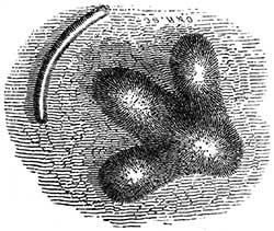
"You are aware that the principal part of these remains are situated in the valley between the Raccoon creek and the South fork of Licking creek. The valley is here nearly two miles wide, from stream to stream. To the east of the lines of embankment and on the second bottom of the creek are numerous mounds. Some of these are very low,—so low, indeed, that a careless observer would hardly distinguish them from the common surface. Some of them are surrounded by a low circular wall of earth which, with a little attention, can be distinctly traced. In the year 1828, when constructing the canal, a lock was located on the site of one of these low mounds. In excavating the lock pit, fourteen human skeletons were found about four feet beneath the surface. These were very much decayed, and supposed by some to have been burnt. It was probably the natural appearance of decomposition which led to this opinion. On coming to the air they all mouldered into dust. Over these skeletons, and carefully and regularly disposed, was laid a large quantity of mica in sheets or plates. Some of these were eight and ten inches long by four and five wide, and all from half an inch to an inch thick. It was estimated that fifteen or twenty bushels of this material were thrown out to form the walls or supports of the lock. From a mound some four feet high, a few rods to the south of this, a large volvaria (sea-shell) was taken.
"On the opposite side of the creek I found, in one place, twenty-four flint axes, or imperfect arrowheads. These were found on the third bottom, on a promontory projecting towards the works in question. A very great quantity of broken flints were found here—enough to load a cart. They were of the same variety of flint, chert, or hornstone, which abounds on 'Flint Ridge.' On that ridge there is the appearance of a great deal of digging. Deep holes cover the ground for the extent of a mile. Many have supposed that these were mines of the precious metals, and no small amount of money and time has been expended in the search. I am of the opinion this place is the source of all the arrow-heads, flint axes, and other implements of that material, which have been used over a wide extent of territory.
"Separate from these valley works, and two miles to the west of them, is an irregular enclosure on a hill. The walls are of earth about three feet high, and enclose an area of some thirty or fort acres extending from the top to the very foot of a high, long, and sloping hill. Again, two miles distant in a north-west direction, the summit of a high hill is surrounded by a similar embankment."
Copyright © 2009 Calvin & Rosanna Hamilton. All rights reserved.