| Hastings Cutoff |
Trail Guide |
Salt Lake City |
Dead Man's Cave |
Benson's Mill |
Grantsville |
Timpie Point |
| Horseshoe Springs | Redlum Springs | Hastings Pass & Summit | West of Hastings Pass | I-80 | Evaporating Pond |
| Floating Island | Silver Island Point | Bomb Target | Donner Springs | Emigrant Graves | All Photos |
| Horseshoe Springs | Redlum Springs | Hastings Pass & Summit | West of Hastings Pass | I-80 | Evaporating Pond |
| Floating Island | Silver Island Point | Bomb Target | Donner Springs | Emigrant Graves | All Photos |
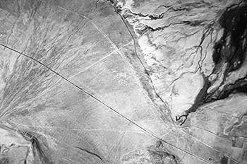 |
| This aerial photograph shows Horseshoe Springs in the lower right hand corner with the Hastings Trail curving up to the center and upper top left portion of the photo. |
The trail is located in the fields to the right and parallels the highway. Drive further south 3.9 miles to the B.L.M. Horseshoe Springs access road then turn right and drive down to the turn around at the springs. The Hastings Trail passes by the BLM sign on the north side and if you look further north you will see a white carsonite marker, this is place where some of the emigrants turned off of the main trail and headed up to Dell Springs, some good springs in the foothills. This trail I call the Forty Niner trail for the Forty Niners who drove their wagons and stock up to the springs. If you look south from this turn around you will see the main Hastings Trail heading on south.
Drive slowly back to the highway and you will see a rail post on your right. It is placed next to the Forty Niner Trail which you can readily see to the south, southeast. The plaque reads:
HASTINGS CUTOFF - HORSESHOE SPRINGS
"Seven miles brought us where the road forked the left hand one leading up a ravine towards the mountain. We took it. ..."
Madison Berryman Moorman, July 27, 1850
2000 Utah Crossroads Chapter - OCTA HU-11
JOHN WOOD in 1850, tells of his travels to Dell Springs:
"2d. - Bright and early, this morning, we were on the road and traveled on through dust and heat for eighteen miles, when we reached two good springs, away up on the side of a mountain, two miles from the road, and going these two last miles, up hill, you ought to have seen the bullocks heave when they smelt the water; . . ."
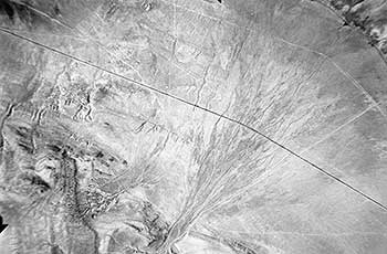 |
| The Hastings Trail is the thin white line curving from the center right to the center top of the photo. The forty niner trail to Dell Springs is the thin white line in the bottom right portion of the photo and goes into the canyon in the center bottom then curves out from the canyon to the upper left hand corner of the photo. |
Drive back to U-189 then turn right and reset the odometer. Drive 1.4 miles and you will see a gravel road on your left with two tall poles and a cable with sign in between. Turn left on to this road and travel 1.9 miles up through a wash and up a hill and then you will come to a fork in the road, take the right hand fork. Drive 0.8 mile further and after crossing a small stream of water you will see a faint road on your left, take it and drive to a rail post. The post is next to Dell Springs. This is the area the Forty Niners camped. The rail post plaque reads:
HASTINGS CUTOFF - DELL SPRINGS
"... we reached 2 good springs, away up on the side of a mountain, two miles from the road. ...about fifty wagons are now camped here" ...
John Wood. Aug 2, 1850
2000 Utah Crossroads Chapter - OCTA HU-12
While you are here at Dell Springs, look around and see if you can see any wild turkeys. On one of our trips we saw 30 turkeys here below the springs.
Backtrack down the same road you came up on until you come back to U-189 then turn left going south. Drive down the road 1.0 miles, slow down, note the white carsonite marker on the left, a pipe going under the highway and a wash going down the hill on the right in a southwest direction. This was a trail depression deepened by water erosion. Continue on south for 1.0 miles until you see a fence and gate on the right. You will cross the Lincoln Highway as you turn right. You will come to a gate with a lock on it , get permission from the BLM ????to unlock the gate. Open or close the gate as you found it then drive to the point in front of you. You will pass a fork in the road, the left hand fork goes down the hill and comes into the Hastings Trail. Keep on the right hand road to the point.
Standing on the rock point you will notice below you the Hastings Cutoff and to your right [north] you will see the Forty Niner Trail coming back into the Hastings Trail from Dell Springs. To the southwest you will see a small lake. This is Kanaka Lake named by the Mormon Hawaiians when they homesteaded just south of here. Look on the rocks to your left and you will find some Indian petroglyphs consisting of concentric circles etched into the rock surfaces.
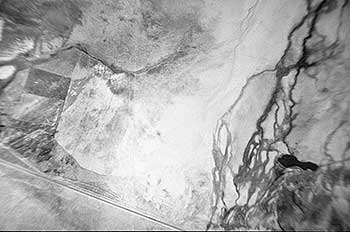 |
| This is an air photo of Hope Wells which is in the lower left corner with Kanaka Lake in the right hand corner. This photo doesn't show much and could be left out. |
Return to the main highway then turn right. Travel 2.1 miles, the road will bend to your left and on your right you will see a gravel road going back north to a gate. You want to go through this gate to see the remains of Hope Wells and its rail post and plaque but first obtain permission from the Ranch people either at the sheds and barns on the west or right side of the road or the first house on the east side of the road to the left. This is now the Ensign Ranch property and courtesy dictates that you should receive permission before entering. This ranch was formally the Desert Livestock Co. and initially Iosepa - a Mormon Hawaiian homestead community.
After receiving permission, drive north through the gate and drive up to the willow trees on the north end. Here you will see a new fence and a rail post just across the fence. The rail post reads:
HASTINGS CUTOFF - HOPE WELLS
The following quotes of J. QUINN THORNTON are from the footnotes in West From Fort Bridger [WFB]: At Hope Wells, Thornton said the company "found a letter from Lansford W. Hastings, informing them that it would occupy two days and nights of hard driving to reach the next water and grass." Eliza P. Donner Houghton, who was only four years old at the time, but who perhaps draws upon the recollections of the older children, writes in The Expedition of the Donner Party and Its Tragic Fate (Chicago, 1911):
"The writing was that of Hastings, and her patchwork brought out the following words: 2 days -2 nights -hard driving-cross -desert-reach water."
Eliza P. Donner Houghton, Aug 27, 1846
2000 Utah Crossroads Chapter - OCTA HU-13
"Close by the largest well stood a rueful spectacle,Ña bewildering guide board, flecked with bits of white paper, showing that the notice or message which had recently been pasted and tacked thereon had since been stripped off in irregular bits. In surprise and consternation, the emigrants gazed at its blank face, then toward the dreary waste beyond. Presently my mother [Tamsen Donner] knelt before it and began searching for fragments of paper, which she believed crows had wantonly pecked off and dropped to the ground. Spurred by her zeal, others also were soon on their knees, scratching among the grasses and sifting the loose soil through their fingers.""What they found, they brought to her and after the search ended she took the guide board, laid it across her lap, and thoughtfully began fitting the ragged edges of paper together and matching the scraps to marks on the board. The tedious process was watched with spellbound interest by the anxious group around her. The writing was that of Hastings, and her patchwork brought out the following words: Ô2 daysÑ2 nightsÑhard drivingÑcrossÑdesertÑreach water.'"
ELIZA DONNER explained about Tamsen Donner piecing together, like a jigsaw puzzle, the torn up note left by Hastings.
The fresh water springs in this area were called Hope Wells. These springs have been depleted due to the pumping of water from the wells to the south and east of here. There is still a spring just a few feet from the post and on this side of the fence. If you look to the meadows to the northwest and west, you can still see the extensive meadows from which the emigrants cut grass to feed their livestock when they were crossing the mud flats. Like the emigrants wrote in their diaries, this was the last good water and abundant feed for the next 93 miles. Return to U-189 and make sure the gate is closed and secured.
HEINRICH LIENHARD finally leaves Hope Wells and crosses Skull Valley to Redlum Spring [WFB]:
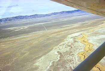 |
| This photo shows the trail heading for Hastings Canyon the low area in the Cedar Mountains ahead. |
"The 17th of August dawned with our stock lying here and there in the grass, contentedly chewing their cuds. The carefree time now past, each of us was occupied loading into the wagons the prepared grass and the small, water-filled receptacles, and that with all possible care, so that under no circumstances should any be lost. The oxen we led once more to water, for now they could drink all they might desire, but this would not be the case hereafter. It was 9 o'clock by the time we set off. Before us lay a broad salt plain or valley [Skull Valley], where grew only a very little thorny, stunted vegetation; indeed, the ground was often a salt crust. Our direction was northwesterly, in a straight line to the mountain opposite [Cedar Mountains]. After a time the road began to ascend a hill, ..."
At the highway turn right and if you would like a side tour to the Hawaiian Cemetery turn left between the two houses, and cross a cattle guard. The community of Iosepa [which means Joseph] was east of the two houses where there are several remaining foundations. Proceed on the gravel road to the left for 0.8 mile to the cemetery where some of the Hawaiians who lived in Iosepa are buried. After your visit return to the main highway.
You will now proceed to Redlum Springs across the valley. At the highway turn south or left and travel 1.6 miles to a dirt road on the west side turn right on this road. Travel west on this road for 1.3 miles. The road will bend to the right and then back to the left. Drive 3.7 miles and look for the turn off on your right. When you have found it turn right or north and drive for 2.9 miles until you come to a white carsonite on your left. The carsonite is on the side of the Hastings Cutoff Trail which bears northwest from Hope Wells. Turn left and drive on the trail. You will come to a playa or mud flat which the trail crosses. Continue until you come to a dry wash. Look for the place to cross the wash and pull up on the steep west bank. The trail from here is hard to follow in places but if you look carefully you will see it. Follow it until you came to a fence without a gate. If you have passenger who would like to walk the trail, this is a good place to hike it for a easy one mile hike after crossing the fence.