| Hastings Cutoff |
Trail Guide |
Salt Lake City |
Dead Man's Cave |
Benson's Mill |
Grantsville |
Timpie Point |
| Horseshoe Springs | Redlum Springs | Hastings Pass & Summit | West of Hastings Pass | I-80 | Evaporating Pond |
| Floating Island | Silver Island Point | Bomb Target | Donner Springs | Emigrant Graves | All Photos |
| Horseshoe Springs | Redlum Springs | Hastings Pass & Summit | West of Hastings Pass | I-80 | Evaporating Pond |
| Floating Island | Silver Island Point | Bomb Target | Donner Springs | Emigrant Graves | All Photos |
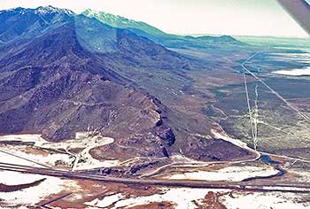 |
| This is Timpie Point a transportation corridor. Jedediah Smith passed here in 1827 as did Fremont in 1845, Clyman & Hastings, in 1846 and the 1846 -1850 emigrants, Western Pacific Railroad in 1909 (now the Union Pacific), the Lincoln Highway in 1915, U.S. 40 in 1940 and now Interstate 80 goes around this northern point of the Stansbury Range. Timpie Point is the rock ledge on the lower left center of the photo just above I-80 and the Railroad. The brackish Big Springs mentioned by the emigrants is in the lower right hand corner of the photo. The Hastings Cutoff is the divergent wavy line to the right of the narrow straight line which is the Lincoln Highway. The trail went around the point where I-80 is today in the bottom portion of the photo. |
Drive up this very rough road to the top of the point. On the top is a rail post marker honoring Jedediah Smith when he came this way in 1827 after crossing the center of Nevada for over a month and not knowing where he was until he came to this point. The plaque reads:
JEDEDIAH SMITH TRAIL - TIMPIE POINT
"Coming to the point of the ridge ... I saw an expanse of water Extending far to the North and East. The Salt Lake a joyful sight was spread before us. ... I durst scarcely believe that it was really the Big Salt Lake that I saw. It was indeed a most cheering view ... Those who may chance to read this at a distance from the scene may perhaps be surprised that the sight of this lake ... excited in me these feelings known to the traveler who after long and perilous journeying comes again in view of his home. ... I had traveled so much in the vicinity of the Salt Lake that it had become my home of the wilderness."
Jedediah Strong Smith, June 27, 1827
2002 Utah Westerners Foundation & Utah Crossroads Chapter OCTA
Standing on the point one has a view of a transportation corridor that went around the point: Fremonts exploration trail of 1845; The Hastings Trail, in 1846; The Western Pacific Railroad [now the Union Pacific] came past here in 1909; The Lincoln Highway in 1913; U.S 40 around 1940; and Interstate 80 about 1980.
Looking back to the east, you can see abandoned U.S. 40, then the Lincoln Highway, and then the Hastings Trail faintly bending in a curve in the sage brush heading for the north end of the point. Walk to the west side of the point. Looking down below the point you can see the Lincoln Highway, and closer to the point the outlines of the Hasting Trail ruts. The trail goes around to the Springs.
JAMES CLYMAN wrote while he and HASTINGS were going eastward on May 27 & 28th 1846:
"1846 June the 1st. proceeded nearly east to the point of a high mountain [Oquirrh Mountains] that Bounds the Southern part of the greate salt lake I observed that this lake like all the rest of this wide spread Sterility has nearly wasted away one half of its surface since 1825 [1826] when I floated around it in my Bull Boate and we crossed a large Bay of this Lake with our horses which is now dry and continued up the South side of the Lake to the vally near the outlet [Jordan River] of the Eutaw Lake and encamped at a fine large spring of Brackish water 20 miles to [sic] today"
Drive cautiously down from the point on the west side 0.6 mile and around the rock outcrop to Big Springs. Here you will see another rail post marker which reads:
HASTINGS CUTOFF - BIG SPRINGS
"Traveled 15 m and encamped by a point of the mountain at a very large spring of brackish water and but little grass". ...
James Mathers, Aug 10, 1846
2000 Utah Crossroads Chapter - OCTA HU-10
Most of the emigrants mentioned these springs and felt the water was too brackish. The trail had to go right on the east side of these springs as did the Lincoln Highway. Look ahead to the south and you can see a straight one lane gravel road, this is the LH. Mark your odometer then drive down this road and if you look to your right in the tall sage brush you can make out the trail. There is a white carsonite marker in the trail almost hidden by the tall brush. Continuing on down this road and you will note the trail moving farther away from you. Travel 2.8 miles and turn right off of the L.H. road and then cross the trail which is plain to see. Continue on to the the paved road which is now U-196, and which goes from I-80 to the Dugway Proving Grounds. Turn left on U-196 and travel south marking your odometer reading. Look to your right and you will see Lone Rock which was noted by some of the emigrants. Lone Rock has many different colored lichens growing on the north side and is the type local for lichens in Utah.
Proceed south for 2.0 miles to the crossing of the trail from the left side to the right side of the road. Continue on to a gravel lane on the right, follow it 0.4 mile and you will note a low meadow on your right. This is the Burnt Springs area. Some of the emigrant diaries indicate that these springs were used by the early emigrants. The springs have since been dried up by the Magnesium Corporation pumping of the ground water in the foothills to the southeast. Continue south on U-196 , you will note some power poles and small concrete block pump sheds, these are the wells of Mag Corp. The water is used at their Rowley Magnesium Plant some 15 or so miles to the northwest.