| Hastings Cutoff |
Trail Guide |
Salt Lake City |
Dead Man's Cave |
Benson's Mill |
Grantsville |
Timpie Point |
| Horseshoe Springs | Redlum Springs | Hastings Pass & Summit | West of Hastings Pass | I-80 | Evaporating Pond |
| Floating Island | Silver Island Point | Bomb Target | Donner Springs | Emigrant Graves | All Photos |
| Horseshoe Springs | Redlum Springs | Hastings Pass & Summit | West of Hastings Pass | I-80 | Evaporating Pond |
| Floating Island | Silver Island Point | Bomb Target | Donner Springs | Emigrant Graves | All Photos |
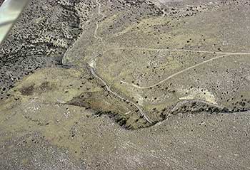 |
| This photo shows the mouth of the canyon where Redlum Spring is located in the upper left hand portion of the photo. |
All vehicles turn left [west] at the fence and follow the faint road until you come to the main gravel road then turn right over the cattle guard. Follow this gravel road for 0.9 mile to where the trail crosses the road and where you will pick up your passengers. There is a white carsonite on the right.
Continue west on this road. Look to your left and you will see the trail across a wash then the trail is the wash because it has been eroded over time by rain waters in the trail depressions. You will come to a big wash after 0.9 mile. The road turns up this wash. If you will look on your right when you turn up the wash or ravine you will see a white carsonite trail marker on the other side. The trail climbed upon the table land while the present gravel road follows up the big wash then climbs out on the right side to a fork in the road (1.0 mile). When on top of the tableland at the fork, turn left, follow the road west to where it forks again, take the right hand road for 0.3 mile to the spring. You will notice on the right hand side toward the spring the trail swale or a depression. Near the spring on the left, is a rail post down near the wash. You can walk down to the post or drive. The rail post plaque reads:
HASTINGS CUTOFF - REDLUM SPRING
"... started for the deseret, passing a salaratus spring in a ravine on the left at the foot of the mountains which we passed. ..."
Hugh Alexander Skinner, July 22, 1850
2000 Utah Crossroads Chapter - OCTA HU -14
A note in West From Fort Bridger says [WFB]:
"Redlum Spring produces little water late in the summer, . . . It is also to be remarked, however, on the basis of the experience of those who traveled the Hastings Cutoff in 1850, that water could be had in many places here by digging for it. This may explain some of the variant information about the character and location of the sulfur-tainted water to which, in reading through the journals of the overland immigrants, we have given the generic name of Redlum Spring."
Redlum Spring is down in the wash below the rail post. You will be able to tell where the water is by the willows and cat tails. This spring has a small flow but some of the emigrants would dig a excavation or small ditch so the animals could drink. Heinrich Lienhard wrote:
"... and about half-past 1 o'clock we reached a spring rather high on the mountainside. We halted here solely that our stock might drink; however, the water, although attractive to look at, was quite salty and the stock were not yet thirsty enough to drink it. Similarly, the small supply of coarse grass in no wise served, for they were not hungry enough to eat it."
JAMES REED after he reached the spring said:
"Son [sunday] 30 made this dayÑ12 [miles] to a Sulpher Spring [Redlum Spring] in the mountain which ought to be avoided water not good for Cattle, emigrants Should keep on the edge of the lake and avoid the mountain entirely here Commenced the long drive through the Salt dessert." [ Underlined for reference].
What Reed is saying, the emigrants should avoid the mountain by continuing west from Big Springs at Timpie Point, through Lowe Pass, missing Redlum Springs and Hastings Pass altogether. This would have added additional mileage to the dry drive since there isn't any water in Lowe Pass but would have been easier on the animals because of the easy pass.
After visiting the spring, retrace your road to the first fork in the road. Turn left and continue on the main road to the north across a wash and until you see another white carsonite marker on your right which is probably the trail. Continue until you again come to a fork in the road. From Redlum to this road is 2.2 miles. Take the left hand fork which will take you up and over Hastings Canyon. The road on the right will take you north about 8 miles to the I-80 Delle Interchange.