| John Bidwell |
Trail Guide |
Historical Background |
Aug 10 |
11 |
12 |
13 |
14 |
15 |
16 |
17 |
18 |
19-20 |
21-22 |
23 |
| 24-25 | 26 | Aug 27 - Sep 4 | 5 | 6 | 7-8 | 9 | 10 | 11 | 12 | 13 | 14 | 15 | All Photos |
| 24-25 | 26 | Aug 27 - Sep 4 | 5 | 6 | 7-8 | 9 | 10 | 11 | 12 | 13 | 14 | 15 | All Photos |
Soda Springs to Corinne
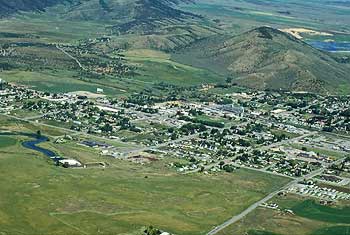 |
| This is Soda Springs, Idaho today. At the lower left is one of the springs where some of the immigrants stopped. The trail generally went around the upper side of town. |
August 10, 1841
The automobile tour starts at the JUNCTION of Main Street and US 30 in Soda Springs, Idaho. Soda Springs is located in southeastern Idaho, 165 miles north of Salt Lake City.
Located on the Oregon Trail, Soda Springs has been known since pioneer days for its mineral salt springs, one of which was named Beer Spring. Alexander Reservoir now covers most of these springs. Writing in his journal on 10 August 1841, John Bidwell described the springs:
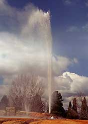 |
| This man-made fountain was formed by tapping into one of the hot spring reservoirs underneath the ground. It can be turned on so that visitors can see what it was like for the early settlers with water shooting into the air. |
The day was fine and pleasant; a soft and cheerful breeze, and the sky bedimmed by smoke, brought to mind the tranquil season of autumn. A distance of ten miles took us to the Soda Fountain, where we stopped the remainder of the day. This is a noted place in the mountains, and is considered a great curiosity; within the circumference of three or four miles there are included no less than 100 springs, some bursting out on top of the ground, others along the banks of the river, which are very low at this place, and some even in the bottom of the river. The water is strongly impregnated with soda, and wherever it gushes out of the ground a sediment is deposited, of a reddish color, which petrifies and forms around the springs large mounds of porous rock, some of which are no less than fifty feet high. Some of these fountains have become entirely dry, in consequence of the column of water which they contained becoming so high as to create sufficient power by its pressure to force the water to the surface in another place. In several of the springs the water was lukewarm, but none were very cold. The ground was very dry at this time, and made a noise as we passed over it with horses as though it was hollow underneath. Cedar grows here in abundance, and the scenery of the country is romantic. Father De Smet, with two or three flathead Indians, started about dark this evening to go to Fort Hall, which was about fifty miles distant.
 |
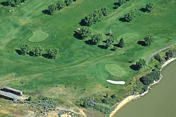 |
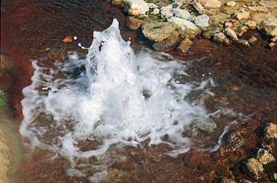
| This is one of the fountains still in Soda Springs with the carbonated water bubbling to the surface. | The Oregon-California Trail went right through this golf course in Soda Springs (lower-left to upper-right). The people who built the golf course did not destroy the trail; they just planted grass right down into the trail. The ruts are still there. |
Travel west on US 30. At 1.2 miles are two historical signs on the left that explain about Soda Springs and Colonel Patrick Edward Connor. Continue west to OREGON TRAIL STATE PARK (2.7 miles).
| Historical Background |
|---|